
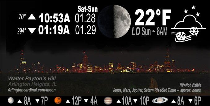
🌓 🌕 🌗 🌑 1st Quarter Moon, sky cover overnight Sat. to Sun. 100%, winds NE to N, 15 MPH, G18 to 24 MPH, Low 22, 8a to 10a
NWS CHGO | NWS HRLY | /NWSchicago | 🌡
ARLINGTON HEIGHTS WEATHER
▴ forecast7 (Arl. Hts.) | RADAR | WIDE RADAR
IMPORTANT NOTE ON NWS DATA
======================
NIGHT FORECASTS …
NOTE 1: Forecast and information text below may refer to a previous night on Arlingtoncardinal.com, and might not be updated until late afternoon, evening, or overnight. However, Night Sky archives on CARDINAL NEWS Magazine include text forecasts that correspond to the lunar phase graphic above.
NOTE 2: Keep in mind lunar rise and set times don’t always correspond with night weather and early morning lows because on some days during the month the moon is visible in the sky predominantly during the daytime hours.
Overnight Saturday/Sunday …
Weather Hazards expected …
Limited Ice Accumulation Risk.
DISCUSSION…
Lingering patchy freezing drizzle is possible this morning, mainly north of I-80.
Hello mobile users! If you encounter mobile “unfriendly” weather page, turn your phone sideways for a better view.
======================
O’HARE FORECAST …
Forecast Beginning Saturday Night, Jan. 28 , 2023 …
Saturday Night: Snow. Steady temperature around 28. Northeast wind 10 to 15 mph, with gusts as high as 25 mph. Chance of precipitation is 100%. New snow accumulation of 1 to 3 inches possible.
Sunday: A chance of snow, mainly before 9am, then a chance of flurries after noon. Cloudy, with a high near 26. North wind around 15 mph, with gusts as high as 25 mph. Chance of precipitation is 50%.
Sunday Night: A chance of flurries. Mostly cloudy, with a low around 11. Wind chill values as low as -2. North northwest wind around 10 mph, with gusts as high as 20 mph.
Monday: A chance of flurries before 7am. Mostly cloudy, with a high near 14. Northwest wind around 10 mph, with gusts as high as 20 mph.
Monday Night: Partly cloudy, with a low around -1.
Tuesday: Mostly sunny, with a high near 14.
Tuesday Night: Mostly clear, with a low around 2.
Wednesday: Mostly sunny, with a high near 24.
Wednesday Night: Mostly cloudy, with a low around 11.
Thursday: Partly sunny, with a high near 27.
Thursday Night: Mostly cloudy, with a low around 12.
Friday: Mostly sunny, with a high near 27.
Friday Night: Mostly cloudy, with a low around 17.
Saturday: Partly sunny, with a high near 32.
O’Hare forecast archive and hourly weather observations archive are available HERE on the CARDINAL NEWS Magazine.
Arlingtoncardinal.com/moonphases
Arlingtoncardinal.com/nightsky
NIGHT SKY THIS MONTH …
Check the night sky objects for this month and past months in the playlist from the Space Telescope Science Institute YouTube channel Backyard stargazers get a monthly guide to the northern hemisphere’s skywatching events with “Tonight’s Sky” (Musical track The Far River written by Jonn Serrie, from the album And the Stars Go With You courtesy of New World Music Ltd. Musical track The Far River written by Jonn Serrie, from the album And the Stars Go With You courtesy of New World Music Ltd).
Telephoto lens, ISO 100, f/11, Shutter Speed 1/100 to 1/125 for the Moon.
Get updates from The Cardinal ALL NEWS FEEDS on Facebook. Just ‘LIKE’ the ‘Arlington Cardinal Page (become a fan of our page). The updates cover all posts and sub-category posts from The Cardinal — Arlingtoncardinal.com. You can also limit feeds to specific categories. See all of The Cardinal Facebook fan pages at Arlingtoncardinal.com/about/facebook …
Help fund The Cardinal Arlingtoncardinal.com/sponsor
Telephoto lens, ISO 1600, f/11, Shutter Speed 2.5″ for the skyline. The skyline exposure was toned down, and brightness and contrast was adjusted in Photoshop.
Area Forecast Discussion
National Weather Service Chicago/Romeoville, IL
1122 PM CST Sat Jan 28 2023
.UPDATE… Issued at 944 PM CST Sat Jan 28 2023
Have made some significant changes to the going forecast this evening to include a snow/freezing rain mix farther north across northern Illinois into the I-88 and even approaching the I-90 corridor through late evening. No changes to current headline structure however with the main snow/freezing rain mix area well delineated by current advisories/warning, but have adjusted wording accordingly. Already a glaze developing here at WFO LOT on untreated and elevated surfaces.
Heavier snow band across our far northern counties has largely shifted north/northeast into southern WI at mid-evening with lighter snow persisting. Farther south, an area of precipitation developing from west-central IL northeast into the Chicago metro has proven to be more of a mix of freezing rain and light snow than earlier forecast, as noted above. RAP/HRRR soundings indicate a loss of better moisture in the mid-levels, making for a shallow moist layer with temps warmer than -10C and not quite cold enough to produce snow outside of deeper precipitation echoes. This mixed precipitation will also move into the Pontiac-Kankakee-Valparaiso areas late this evening, in the southern part of the current winter weather advisory area.
Will continue to monitor for trends into early Sunday morning prior to ending.
Ratzer
&&
.SHORT TERM… Issued at 350 PM CST Sat Jan 28 2023
Through Sunday night…
Key messages are:
* Regular snow along and north of I-88/290 through mid-evening, heavy at times with one inch per hour rates toward the Wisconsin state line, resulting in hazardous travel
* Snow and mixed precipitation expanding south of I-88/290 by early evening, with slick roadways probable – Winter Weather Advisory has been expanded for this reason
* Steady temperatures through this evening then slowly falling through Sunday morning and very little rebound in the afternoon
Banded moderate to heavy snow over far northern Illinois this afternoon resides along a taunt 850 mb temperature gradient (from 0C near I-80 to -10C near Milwaukee). This gradient is forecast to tighten some in the coming hours as a response to a thermally direct vertical circulation underneath a 130 kt upper jet centered over the Illinois-Wisconsin stateline. The responding frontogenesis near ~900-800 mb will likely keep banded snow redeveloping in the far northern forecast area through early to mid evening. Diagnostic guidance (such as initialized RAP) indicates negative saturated EPV above this f-gen layer, and observational trends have supported the likely presence of slantwise and possibly upright instability. Would expect to continue to see bands of heavier snowfall rates materialize within this setup near the stateline area. It`s still certainly possible that the heaviest amounts fall just north of the stateline where banded snow becomes truly stationary — even this near term it`s difficult to pin down banded snow behavior.
Snow ratios have varied some via reports and webcam imagery from the first few hours, with larger flakes having trended smaller indicative of a lowering ratio. The greatest lift looks below the DGZ, and the DGZ itself is not that deep. So ratios may continue to be around 11:1 or so, but QPF bursts within bands and anomalously high moisture (PWATs around 0.45 of an inch) will help make up for that.
Stepping back on the broader scale, the next short wave (which really is the main wave) will move from Iowa through northern Illinois this evening and early overnight. Increasing saturated upglide ahead of this should support an expansion in precipitation, which may have more of a shower mode. The precipitation across western Illinois into the southern CWA. The precipitation type with this is borderline, as the main lift is below the ice nucleation layer especially along and south of I-80, and saturation in that nucleation layer becomes somewhat marginal too. This presents the freezing rain threat. This is mainly from the Kankakee River to Pontiac northward to a little north of I-80. Because the thermal gradient will not change much, this zone could have several hours worth of freezing rain showers. This area also did not see surface temperatures climb above freezing today like the far south did, although pavement sensors indicate the pavement is 33-36F. Would think this should dip below tonight, and that`s why collaboratively the Winter Weather Advisory was expanded. Even if it is only a light amount of freezing rain, it never takes much of that to cause issues.
On the back side of the short wave, the snow area should pivot southeastward expanding back over Chicago during mid to late evening, with a return of more moderate snowfall rates. Confidence is low on specific accumulations here, as saturation in the DGZ starts to ease, but enough of a snowfall rate should occur for accumulation on roadways once again. It also is low confidence on how far south this reaches, as mild air at 850 mb (near 0C) will likely be near the south metro and far northwest Indiana, so these locations may struggle to go back to solid snow and just reside in on and off freezing rain/snow mix. Precipitation overall should be tapering in intensity late evening and more so overnight with the short wave progressing on. In the Winter Storm Warning area, impacts will likely be easing by later evening, though patchy shallow blowing snow and light falling snow will probably be ongoing. One exception may be near the lake where some slight enhancement to ongoing snow may occur as cold air starts to wrap in.
For Sunday morning, cyclonic flow over the area will continue the potential for at least flurries, as well as lake effect snow showers though lake-induced equilibrium levels look only on the order of 4,500 ft and cloud depths around 3,000 ft. This will actually get a bit better Sunday night, with colder air inching the column into the DGZ. Some minor additional snow accumulation in far northwest Indiana may occur. Elsewhere, a weak short wave passing through central Illinois may also result in some light snow in the far south Sunday night and continue flurry potential elsewhere.
MTF/NWS Chicago
