
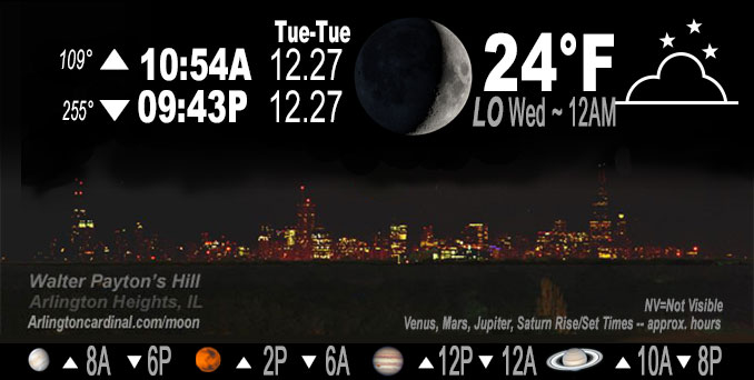
🌒 🌓 🌕 🌗 Waxing Crescent Moon, sky cover overnight Tue. to Wed. 46% to 59% to 30%, winds SSW, 17 to 18 to 17 MPH, G29 to 30 to 28 MPH, Low 24, 12a to 1a
NWS CHGO | NWS HRLY | /NWSchicago | 🌡
ARLINGTON HEIGHTS WEATHER
▴ forecast7 (Arl. Hts.) | RADAR | WIDE RADAR
IMPORTANT NOTE ON NWS DATA
======================
Overnight Tuesday/Wednesday …
No Weather Hazards expected …
DISCUSSION…
Milder temperatures on basically an increasing trend overnight all the way through Thursday on breezy southerly winds.
Southerly flow has enveloped the area and will continue through the next couple days as broad but strong low pressure develops and consolidates across the Northern Plains. This return flow is largely dry tonight.
Hello mobile users! If you encounter mobile “unfriendly” weather page, turn your phone sideways for a better view.
======================
O’HARE FORECAST …
Forecast Beginning Tuesday Night, Dec. 27, 2022 …
Tuesday Night: Partly cloudy, with a low around 22. Breezy, with a south southwest wind 15 to 20 mph, with gusts as high as 30 mph.
Wednesday: Mostly sunny, with a high near 40. Breezy, with a south wind 15 to 20 mph, with gusts as high as 30 mph.
Wednesday Night: A chance of drizzle after 3am. Mostly cloudy, with a low around 39. Breezy, with a south southwest wind 15 to 20 mph, with gusts as high as 30 mph.
Thursday: A chance of drizzle before noon, then a chance of drizzle with a slight chance of rain after noon. Patchy fog before noon. Otherwise, cloudy, with a high near 50. South southwest wind around 15 mph, with gusts as high as 30 mph. Chance of precipitation is 20%.
Thursday Night: A 40 percent chance of rain. Cloudy, with a low around 40. South southwest wind 10 to 15 mph, with gusts as high as 25 mph.
Friday: A 20 percent chance of rain before noon. Mostly cloudy, with a high near 43.
Friday Night: Mostly cloudy, with a low around 31.
Saturday: A chance of rain. Mostly cloudy, with a high near 41.
Saturday Night: A chance of rain. Cloudy, with a low around 34.
New Year’s Day: Mostly cloudy, with a high near 43.
Sunday Night: Mostly cloudy, with a low around 33.
Monday: A chance of rain. Cloudy, with a high near 49.
Monday Night: Rain likely. Cloudy, with a low around 40.
Tuesday: A chance of rain. Cloudy, with a high near 51.
O’Hare forecast archive and hourly weather observations archive are available HERE on the CARDINAL NEWS Magazine.
Arlingtoncardinal.com/moonphases
Arlingtoncardinal.com/nightsky
NIGHT SKY THIS MONTH …
Check the night sky objects for this month and past months in the playlist from the Space Telescope Science Institute YouTube channel Backyard stargazers get a monthly guide to the northern hemisphere’s skywatching events with “Tonight’s Sky” (Musical track The Far River written by Jonn Serrie, from the album And the Stars Go With You courtesy of New World Music Ltd. Musical track The Far River written by Jonn Serrie, from the album And the Stars Go With You courtesy of New World Music Ltd).
Telephoto lens, ISO 100, f/11, Shutter Speed 1/100 to 1/125 for the Moon.
Get updates from The Cardinal ALL NEWS FEEDS on Facebook. Just ‘LIKE’ the ‘Arlington Cardinal Page (become a fan of our page). The updates cover all posts and sub-category posts from The Cardinal — Arlingtoncardinal.com. You can also limit feeds to specific categories. See all of The Cardinal Facebook fan pages at Arlingtoncardinal.com/about/facebook …
Help fund The Cardinal Arlingtoncardinal.com/sponsor
Telephoto lens, ISO 1600, f/11, Shutter Speed 2.5″ for the skyline. The skyline exposure was toned down, and brightness and contrast was adjusted in Photoshop.
Area Forecast Discussion
National Weather Service Chicago/Romeoville, IL
545 PM CST Tue Dec 27 2022
.SHORT TERM… Issued at 240 PM CST Tue Dec 27 2022
Through Thursday…
The key short term forecast messages are:
* Milder temperatures on basically an increasing trend overnight all the way through Thursday on breezy southerly winds
* Chance of drizzle and possibly fog late Wednesday night through Thursday
Southerly flow has enveloped the area and will continue through the next couple days as broad but strong low pressure develops and consolidates across the Northern Plains. This return flow is largely dry tonight, although residual stratus across far eastern Illinois and central/southern Indiana is expected to be pulled northward over at least northwest Indiana this evening. This stratus is thin (500-1000 ft) per diagnostic soundings, but trapped under a strengthening inversion, so is should hold its own as it gets shoved north. Also passing high clouds elsewhere will lead to a variable nature of sky cover. Enough of a clear sky in north central Illinois initially this evening may offset the southerly winds for a few degree temperature drop, but after that the entire CWA should experience a slow temperature climb.
Wednesday presents some challenges in how strong wind gusts will be and how high temperatures will climb. The strongest pressure falls of this return flow episode (3 to 5 mb per six hours) spread over the area on Wednesday. Cloud cover does not look thick, and there may very well be a mostly sunny sky, with the aforementioned low clouds in the eastern CWA tonight forecast to depart to the east. While mixing will likely be stunted some by the remaining snow cover, forecast gusts of 25 to 35 mph from north to south look reasonable. With 925 mb temperatures climbing a few degrees on the positive side of 0C by afternoon, this would support highs of 40F with snow cover at Chicago per late December climatology. This seems reasonable and may speak for most of the CWA, and is near the 25th percentile (coolest quarter) of the National Blend of Models (NBM) forecast. It should be noted, there are some models and MOS forecasting notably warmer (i.e. near 50F) in the southern CWA, but this seems too warm given the edge of the snow cover at present is well upstream in the southerly flow — currently along the Kentucky/Tennessee border.
Strengthening warm and moist advection in the low-levels is forecast Wednesday night as a secondary low near 1002 mb takes shape near Kansas City along the system cold front. During the overnight there is a pronounced signal of increasing saturation in the 1-4 kft layer and attendant isentropic ascent forecast on the 280-285K layer. That`s a fairly good signal for drizzle. The ECMWF remains the slowest with this compared to NCEP models, but all guidance shows this Thursday morning. With some sun expected during the day Wednesday and high temperatures in the upper 30s to 40F, this should help boost pavement temperatures. As an example, this afternoon`s sun along the I-39 corridor boosted pavement temperatures into the mid to upper 20s (5-8F above air temperatures). So feel that with a late arrival of drizzle chances, as it stands now, that the potential for initial freezing drizzle is quite low. If drizzle were to be several hours earlier it may be a concern given dew points around 30F in the evening, but at this time this is a lower likelihood solution.
Thursday looks to be a stratus-filled day and that stratus should be thick. Besides the potential for drizzle, fog, and even a few afternoon light rain showers, these clouds will inhibit warming from maximum potential. How much so is still a challenge. The 925 mb temperatures are forecast to warm to 9C to 10C, supportive of mid to upper 50s. The snow cover will diminish to zero during Thursday but the clouds themselves point toward keeping the forecast more toward the 25th percentile of guidance (upper 40s to lower 50s). The most uncertainty is in the southwestern CWA, where cloud thickness is forecast to diminish in the afternoon. Would not be surprised if that occurs that Pontiac or Peru jum Pinto the upper 50s, but at this time still too low of confidence.
MTF/NWS Chicago
