
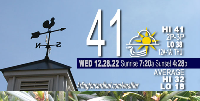
Wednesday Hi 41, partly cloudy then partly sunny, winds SSW, 15 to 12 to 16 MPH, G28 to 32 to 30 to 32 MPH
NWS CHGO | NWS HRLY | /NWSchicago | 🌡
ARLINGTON HEIGHTS WEATHER
▴ forecast7 (Arl. Hts.) | RADAR | WIDE RADAR
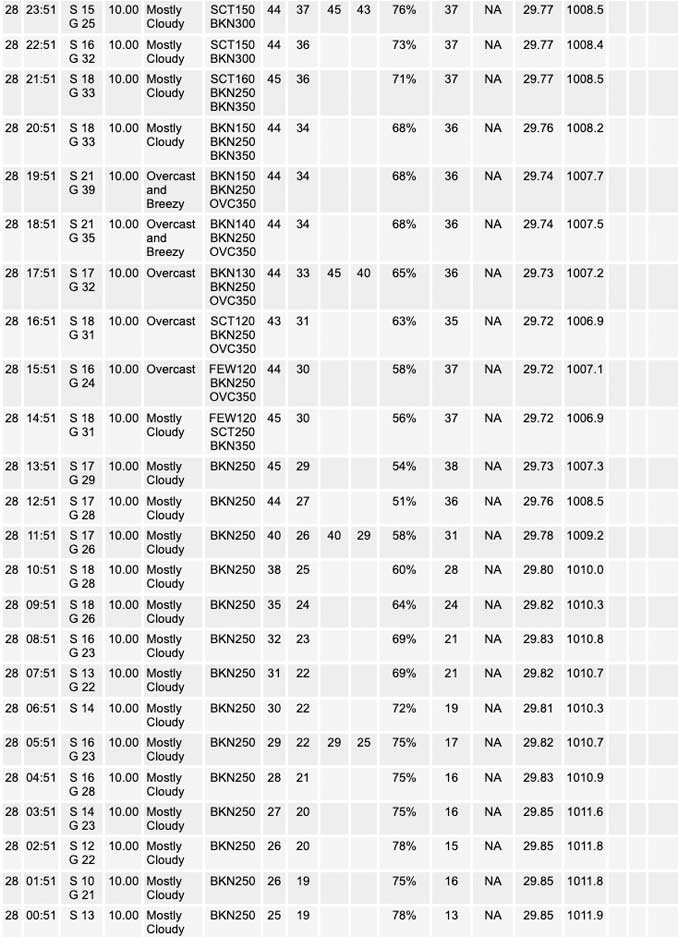
⏪ Hrly Data Table | Hrly Future Graph ⏩
IMPORTANT NOTE ON NWS DATA
⏪ Hrly Data Table | Hrly Future Graph ⏩
======================
Wednesday and Wednesday Night …
No Weather Hazards expected…
Limited Excessive Cold Risk this morning.
DISCUSSION…
Tight (and tightening) pressure gradient between lee trough over the northern and central High Plains and high pressure off the east coast will result in brisk southerly winds through Thursday. The southerly flow will advect milder air north into the region, but will initially be chilled by snow cover.
Hello mobile users! If you encounter a mobile “unfriendly” weather page, turn your phone sideways for a better view.
======================
O’HARE FORECAST …
Forecast Beginning Wednesday, Dec. 28, 2022
Wednesday: Mostly sunny, with a high near 42. Breezy, with a south wind 15 to 20 mph, with gusts as high as 30 mph.
Wednesday Night: Increasing clouds, with a low around 39. Breezy, with a south southwest wind 15 to 20 mph, with gusts as high as 30 mph.
Thursday: A chance of drizzle between 7am and 1pm, then a slight chance of showers after 1pm. Cloudy, with a high near 54. South southwest wind around 15 mph, with gusts as high as 20 mph. Chance of precipitation is 20%.
Thursday Night: A 50 percent chance of showers, mainly after 7pm. Cloudy, with a low around 40. South wind 10 to 15 mph, with gusts as high as 25 mph.
Friday: A chance of showers before 7am, then a slight chance of rain between 7am and 1pm. Mostly cloudy, with a high near 45. Southwest wind 5 to 10 mph, with gusts as high as 15 mph. Chance of precipitation is 50%.
Friday Night: Mostly cloudy, with a low around 31.
Saturday: A 30 percent chance of rain, mainly after 1pm. Mostly cloudy, with a high near 43.
Saturday Night: A chance of rain before 1am. Mostly cloudy, with a low around 34.
New Year’s Day: Mostly cloudy, with a high near 44.
Sunday Night: Mostly cloudy, with a low around 35.
Monday: A chance of rain. Cloudy, with a high near 51.
Monday Night: Rain. Cloudy, with a low around 45.
Tuesday: Rain likely. Mostly cloudy, with a high near 53.


CHICAGOWEATHERSTATION.COM

ChicagoWeatherStation.com I O’Hare Normal Temps/Precip I O’Hare Record Temps, Precip, Snow
LIVE RADAR | STORM TRACKS | UNISYS US IR SAT | UNISYS Midwest IR SAT | UNISYS More IR SAT
WunderMap® with Temperature/Wind Data || Google: Arlington Heights Area Temps | US TEMPS
Full Screen Motion Weather Radar (Wunderground.com)
Midwest Cloud Cover with Arlington Heights Weather Forecast
ChicagoWeatherStation.com I O’Hare Normal Temps/Precip I O’Hare Record Temps, Precip, Snow
SUNLIGHT DATA FOR SECURITY, TRAFFIC SAFETY, AND SPORTS
SunCalc.net data with solar azimuth and trajectory, times for dawn, sunrise, solar noon, sunset, dusk …
NIGHT SKY THIS MONTH …
Backyard stargazers get a monthly guide to the northern hemisphere’s skywatching events with “Tonight’s Sky.” Check the night sky objects for this month and past months in the playlist from the Space Telescope Science Institute YouTube channel (Musical track The Far River written by Jonn Serrie, from the album And the Stars Go With You courtesy of New World Music Ltd).
Get updates from The Cardinal ALL NEWS FEEDS on Facebook. Just ‘LIKE’ the ‘Arlington Cardinal Page (become a fan of our page). The updates cover all posts and sub-category posts from The Cardinal — Arlingtoncardinal.com. You can also limit feeds to specific categories. See all of The Cardinal Facebook fan pages at Arlingtoncardinal.com/about/facebook …
Help fund The Cardinal Arlingtoncardinal.com/sponsor
Area Forecast Discussion
National Weather Service Chicago/Romeoville, IL
532 AM CST Wed Dec 28 2022
.SHORT TERM… Issued at 244 AM CST Wed Dec 28 2022
Through Thursday night…
Tight (and tightening) pressure gradient between lee trough over the northern and central High Plains and high pressure off the east coast will result in brisk southerly winds through Thursday. The southerly flow will advect milder air north into the region, though that will likely be tempered (initially) by snow cover.
Nudged high temps up a bit today (lower 40s Chicago metro and southern CWA to upper 30s elsewhere) to be in line with guidance temps which also match the 925mb climo temps with snow cover. Tight pressure gradient should keep southerly winds blowing rather briskly through tonight, which should result in nearly steady temps through the night. Given the low density nature of the snow cover, suspect the upper 30 to lower 40 degree temps should be rather effective in eating away at the snow today into tonight, despite the rather low dewpoints. The HRRR shows snow depth down to zero by late tonight over almost all of our CWA, while GFS and especially the NAM depict minimal melting and maintain a snow cover through the day on Thursday.
This model depicted snow cover in the NAM and GFS results in lower 2m temps, higher 2m RH, and sounding profiles that look quite drizzly and foggy. Given the low moisture content of the snow cover, suspect the HRRR probably has a better handle of the snowmelt and near sfc conditions. Lower boundary layer RH in the HRRR would also suggest a lower risk of fog and drizzle tonight into Thursday. As a nod to the GFS/NAM, did maintain a chance of drizzle Thursday morning as stratus overspreads the area, however if the favored HRRR solution verifies drizzle may not occur. After the loss of snow cover, the HRRR depicts the strong southerly resulting in temps rising in tandem with dewpoints late tonight and boundary layer never becoming saturated (in other words, lower drizzle and fog threat).
Did blend the milder HRRR temps in for Thursday, though not quite as mild as the HRRR which would have mid 50s to around 60s across most of the CWA for highs (low 50s near the WI border). Certainly think those temps are quite attainable, but opted not to go all in on the HRRR in case stratus is thicker/lower as both the GFS and NAM depict.
Finally, other than the small chance of drizzle Thursday morning, looks like rain chances should hold off until later Thursday afternoon or more likely Thursday evening. As an approaching cold front encounters a more moisture rich air mass east of the MS River look showers to break out along and ahead of the front. Moderately steep mid level lapse rates (7C/km in 700-500mb layer) along with unseasonably moist air mass ahead of the front, suggests there is a non-zero chance of an isolated thunderstorm or two Thursday evening. Didn`t add thunder to the forecast, but something to take another look at in later forecasts. The shower (and isolated thunder?) threat should end west to east overnight Thursday as cold front moves across the area. Cooler and less humid (though still warmer than average) air mass will filter in behind the front.
Izzi/NWS Chicago
