
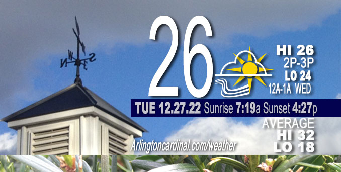
Tuesday Hi 26, partly cloudy then mostly cloudy, winds SW to S to SW, 8 to 12 to 19 MPH, G17 to 26 to 30 MPH, 11a through Wednesday
NWS CHGO | NWS HRLY | /NWSchicago | 🌡
ARLINGTON HEIGHTS WEATHER
▴ forecast7 (Arl. Hts.) | RADAR | WIDE RADAR
⏪ Hrly Data Table | Hrly Future Graph ⏩
IMPORTANT NOTE ON NWS DATA
⏪ Hrly Data Table | Hrly Future Graph ⏩
======================
Tuesday and Tuesday Night …
Weather Hazards expected…
Limited Excessive Cold Risk this morning.
DISCUSSION…
Temperatures are in the single digits this morning with subzero wind chills in spots. Bundle up before heading out.
Hello mobile users! If you encounter a mobile “unfriendly” weather page, turn your phone sideways for a better view.
======================
O’HARE FORECAST …
Forecast Beginning Tuesday, Dec. 27, 2022
Tuesday: Mostly sunny (becoming cloudy), with a high near 25. Wind chill values as low as 0. South Southwest wind 5 to 15 mph, with gusts as high as 25 mph.
Tuesday Night: Partly cloudy (mostly cloudy), with a low around 23 (22). South southwest wind around 15 to mph, with gusts as high as 30 mph.
Wednesday: Partly sunny, with a high near 40. South southwest wind around 15 mph, with gusts as high as 30 mph.
Wednesday Night: Mostly cloudy, with a low around 36.
Thursday: A 20 percent chance of rain after noon. Cloudy, with a high near 52.
Thursday Night: A chance of rain. Cloudy, with a low around 41.
Friday: A chance of rain. Cloudy, with a high near 49.
Friday Night: Rain likely. Cloudy, with a low around 38.
Saturday: Rain likely. Cloudy, with a high near 46.
Saturday Night: A chance of rain. Cloudy, with a low around 37.
New Year’s Day: Mostly cloudy, with a high near 44.
Sunday Night: Mostly cloudy, with a low around 33.
Monday: A chance of rain. Cloudy, with a high near 49.
Monday Night: Rain likely. Cloudy, with a low around 40.


CHICAGOWEATHERSTATION.COM

ChicagoWeatherStation.com I O’Hare Normal Temps/Precip I O’Hare Record Temps, Precip, Snow
LIVE RADAR | STORM TRACKS | UNISYS US IR SAT | UNISYS Midwest IR SAT | UNISYS More IR SAT
WunderMap® with Temperature/Wind Data || Google: Arlington Heights Area Temps | US TEMPS
Full Screen Motion Weather Radar (Wunderground.com)
Midwest Cloud Cover with Arlington Heights Weather Forecast
ChicagoWeatherStation.com I O’Hare Normal Temps/Precip I O’Hare Record Temps, Precip, Snow
SUNLIGHT DATA FOR SECURITY, TRAFFIC SAFETY, AND SPORTS
SunCalc.net data with solar azimuth and trajectory, times for dawn, sunrise, solar noon, sunset, dusk …
NIGHT SKY THIS MONTH …
Backyard stargazers get a monthly guide to the northern hemisphere’s skywatching events with “Tonight’s Sky.” Check the night sky objects for this month and past months in the playlist from the Space Telescope Science Institute YouTube channel (Musical track The Far River written by Jonn Serrie, from the album And the Stars Go With You courtesy of New World Music Ltd).
Get updates from The Cardinal ALL NEWS FEEDS on Facebook. Just ‘LIKE’ the ‘Arlington Cardinal Page (become a fan of our page). The updates cover all posts and sub-category posts from The Cardinal — Arlingtoncardinal.com. You can also limit feeds to specific categories. See all of The Cardinal Facebook fan pages at Arlingtoncardinal.com/about/facebook …
Help fund The Cardinal Arlingtoncardinal.com/sponsor
Area Forecast Discussion
National Weather Service Chicago/Romeoville, IL
527 AM CST Tue Dec 27 2022
.SHORT TERM… Issued at 229 AM CST Tue Dec 27 2022
Through Wednesday…
A relatively quiet night is underway across northeastern Illinois and northwest Indiana courtesy of a broad surface high that is moving across the southern United States. While most of the area remains under clear skies an area of stratus continues to linger over portions of central Illinois and northwestern Indiana, but recent satellite observations are showing the stratus to be slowly moving east. This gradual clearing of the stratus looks to continue through the night as a narrow wedge of drier air filters in aloft. As the stratus clears temperatures across this area are expected to cool to near the dew point temperatures, which may allow for the development of some patchy fog for areas along and east of I-57 where the best low-level moisture currently resides. However, forecast soundings are showing marginal conditions at best with most indicating that the lower atmosphere would struggle to reach saturation. For now I have maintained the patchy fog mention in the forecast as some locations in northwestern Indiana are getting close to saturation but confidence continues to be low in fog development. If any fog does develop it should be rather shallow in nature and cause only minor reductions in visibility. Otherwise expect the cirrus clouds over the upper Midwest to continue moving into northeastern Illinois through the morning as temperatures dip into the single digits with a few spots flirting with negative temperatures by daybreak.
Southerly winds will gradually increase in speed through the day today with gusts around 25 to 30 mph expected by late afternoon/early evening. There continues to be uncertainty in how well the atmosphere would be able to mix this evening despite a strong 50 kt low-level jet moving overhead. Forecast soundings continue to show that the mid-levels would be warming faster than the surface which should create a strong inversion in the low levels just below the aforementioned jet which may prevent the strongest gusts from reaching the surface. I did lower wind gusts overnight slightly to account for this potential, but still have gusts around 25 mph, which seems reasonable given how low to the ground the jet is forecast to be. Better mixing is expected to develo PWednesday afternoon which should allow gusts to reach upwards of 25 to 30 mph with a few higher gusts looking possible.
These southerly winds will also advect in warmer air which will gradually warm temperatures through the end of the period. Highs this afternoon are expected to top out in the mid-20s and hold nearly steady overnight if not warm slightly. Warmer temperatures are expected on Wednesday with highs forecast to reach the mid to upper 30s with a couple spots possibly hitting 40 degrees.
Yack/NWS Chicago
