
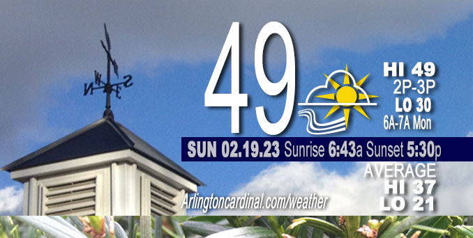
Sunday Hi 49, partly sunny to mostly sunny to mostly cloudy, winds SW to W to NW, 15 to 20 to 8 MPH, G25 to 31 to 13 MPH end Monday 2a
NWS CHGO | NWS HRLY | /NWSchicago | 🌡
ARLINGTON HEIGHTS WEATHER
▴ forecast7 (Arl. Hts.) | RADAR | WIDE RADAR
⏪ Hrly Data Table | Hrly Future Graph ⏩
IMPORTANT NOTE ON NWS DATA
⏪ Hrly Data Table | Hrly Future Graph ⏩
======================
Sunday and Sunday Evening …
No Weather Hazards expected …
Wind gusts upwards of 30 mph through the early part of Sunday afternoon are forecast before winds gradually ease heading into the evening behind a weak cold front.
DISCUSSION…
Mid-level clouds are expected to clear the area later Sunday morning which will leave us under mostly sunny skies for Sunday afternoon before clouds increase behind the cold front this evening.
Daily low temperatures and daily high temperatures are on the way up. We’re gaining about 2 minutes of daylight every day in the progression toward vernal equinox, March 20, 2023. We gained 3 minutes of daylight on Sunday, February 19, 2023.
======================
O’HARE FORECAST …
Forecast Beginning Sunday, Feb. 19, 2023
Sunday: Mostly sunny, with a high near 49. Breezy, with a south southwest wind 15 to 20 mph, with gusts as high as 30 mph.
Sunday Night: Mostly cloudy, with a low around 30. West wind 5 to 10 mph becoming north northwest after midnight. Winds could gust as high as 20 mph.
Monday Washington’s Birthday: Partly sunny, with a high near 45. Northwest wind 5 to 10 mph becoming south in the morning. Winds could gust as high as 15 mph.
Monday Night: Partly cloudy, with a low around 29. South southwest wind 10 to 15 mph becoming west after midnight. Winds could gust as high as 30 mph.
Tuesday: Mostly sunny, with a high near 38. West wind 10 to 15 mph becoming north northwest 5 to 10 mph in the afternoon. Winds could gust as high as 30 mph.
Tuesday Night: A slight chance of rain and snow after midnight. Mostly cloudy, with a low around 31. Chance of precipitation is 20%.
Wednesday: Rain, mainly after noon. High near 36. Breezy. Chance of precipitation is 90%.
Wednesday Night: Rain, mainly before midnight. Cloudy, with a low around 33. Breezy.
Thursday: Mostly cloudy, with a high near 45. Breezy.
Thursday Night: Mostly cloudy, with a low around 18. Breezy.
Friday: Partly sunny, with a high near 31.
Friday Night: A chance of snow. Mostly cloudy, with a low around 27.
Saturday: Mostly cloudy, with a high near 40.


CHICAGOWEATHERSTATION.COM

ChicagoWeatherStation.com I O’Hare Normal Temps/Precip I O’Hare Record Temps, Precip, Snow
LIVE RADAR | STORM TRACKS | UNISYS US IR SAT | UNISYS Midwest IR SAT | UNISYS More IR SAT
WunderMap® with Temperature/Wind Data || Google: Arlington Heights Area Temps | US TEMPS
Full Screen Motion Weather Radar (Wunderground.com)
Midwest Cloud Cover with Arlington Heights Weather Forecast
ChicagoWeatherStation.com I O’Hare Normal Temps/Precip I O’Hare Record Temps, Precip, Snow
SUNLIGHT DATA FOR SECURITY, TRAFFIC SAFETY, AND SPORTS
SunCalc.net data with solar azimuth and trajectory, times for dawn, sunrise, solar noon, sunset, dusk …
NIGHT SKY THIS MONTH …
Backyard stargazers get a monthly guide to the northern hemisphere’s skywatching events with “Tonight’s Sky.” Check the night sky objects for this month and past months in the playlist from the Space Telescope Science Institute YouTube channel (Musical track The Far River written by Jonn Serrie, from the album And the Stars Go With You courtesy of New World Music Ltd).
Get updates from The Cardinal ALL NEWS FEEDS on Facebook. Just ‘LIKE’ the ‘Arlington Cardinal Page (become a fan of our page). The updates cover all posts and sub-category posts from The Cardinal — Arlingtoncardinal.com. You can also limit feeds to specific categories. See all of The Cardinal Facebook fan pages at Arlingtoncardinal.com/about/facebook …
Help fund The Cardinal Arlingtoncardinal.com/sponsor
Area Forecast Discussion
National Weather Service Chicago/Romeoville, IL
520 AM CST Sun Feb 19 2023
.SHORT TERM… Issued at 325 AM CST Sun Feb 19 2023
Through Monday…
Northeastern Illinois and northwest Indiana continues to be sandwiched between a broad surface high over the southeastern CONUS and a developing surface low over the upper Midwest which is creating breezy southerly winds across the area this morning. Gusts of 20 to 25 mph are being reported across the area and are expected to continue through daybreak then increase as the atmosphere begins to mix into the base of a 40 kt low-level jet. This will generate gusts upwards of 30 mph through the early part of the afternoon before winds gradually ease heading into the evening behind a weak cold front.
Additionally, the warm advection generated by the aforementioned winds in combination with a weak upper-level disturbance sliding overhead is also generating a broad area of mid-level clouds and possible virga. Radar continues to show an area of 10 to 20 dbz echoes moving across central and northwestern Illinois, but ground stations have not reported any precipitation as of yet due to the dry layer below the cloud bases as noted in recent aircraft soundings. While I do not suspect we will see much of anything from these echoes as they continue to move northeastward across the area, I did maintain a chance of sprinkles in the forecast through daybreak just in case.
The mid-level clouds are expected to clear the area later this morning which will leave us under mostly sunny skies for our Sunday afternoon before clouds increase behind the aforementioned cold front this evening. The combination of sunshine and warm advection should allow temperatures to climb into the mid to upper 40s and lower 50s areawide this afternoon. While the cold front will briefly turn winds northwesterly this evening and cool temperatures into the upper 20s and lower 30s tonight, south-southwesterly flow is expected to redevelop during the day on Monday which should allow temperatures to rebound into the 40s to near 50 degrees despite the increased cloud cover.
Yack/NWS Chicago
