
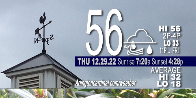
Thursday Hi 56, cloudy, scattered showers after 9p, winds SW to SSW to SW, 17 to 15 MPH, G32 to 26 MPH
NWS CHGO | NWS HRLY | /NWSchicago | 🌡
ARLINGTON HEIGHTS WEATHER
▴ forecast7 (Arl. Hts.) | RADAR | WIDE RADAR
⏪ Hrly Data Table | Hrly Future Graph ⏩
IMPORTANT NOTE ON NWS DATA
⏪ Hrly Data Table | Hrly Future Graph ⏩
======================
Thursday and Thursday Night …
Weather Hazards expected…
Limited Non Thunderstorm Wind Risk.
DISCUSSION…
Breezy south to southwest winds could gust up to 35 mph today. Snow cover has melted overnight taking some of the chill out high wind gusts. Thursday should have a much milder feel, even with the sun covered by mostly cloudy conditions.
Hello mobile users! If you encounter a mobile “unfriendly” weather page, turn your phone sideways for a better view.
======================
O’HARE FORECAST …
Forecast Beginning Thursday, Dec. 29, 2022
Thursday: Cloudy, with a high near 56. South wind around 15 mph, with gusts as high as 30 mph.
Thursday Night: Scattered showers between 10pm and 3am. Cloudy, with a low around 36. South southwest wind around 15 mph, with gusts as high as 30 mph. Chance of precipitation is 40%.
Friday: Cloudy, with a high near 40. West wind 5 to 10 mph, with gusts as high as 20 mph.
Friday Night: A chance of rain and snow, mainly after midnight. Cloudy, with a low around 31. Calm wind becoming northeast around 5 mph. Chance of precipitation is 30%.
Saturday: A slight chance of rain and snow before 9am, then a slight chance of rain. Mostly cloudy, with a high near 42. Northeast wind around 5 mph, with gusts as high as 15 mph. Chance of precipitation is 20%.
Saturday Night: A 20 percent chance of rain before midnight. Mostly cloudy, with a low around 32.
New Year’s Day: Mostly cloudy, with a high near 45.
Sunday Night: Cloudy, with a low around 34.
Monday: A chance of rain after noon. Cloudy, with a high near 48.
Monday Night: Rain. Cloudy, with a low around 46.
Tuesday: A chance of rain. Mostly cloudy, with a high near 54.
Tuesday Night: Mostly cloudy, with a low around 34.
Wednesday: Mostly cloudy, with a high near 38.


CHICAGOWEATHERSTATION.COM

ChicagoWeatherStation.com I O’Hare Normal Temps/Precip I O’Hare Record Temps, Precip, Snow
LIVE RADAR | STORM TRACKS | UNISYS US IR SAT | UNISYS Midwest IR SAT | UNISYS More IR SAT
WunderMap® with Temperature/Wind Data || Google: Arlington Heights Area Temps | US TEMPS
Full Screen Motion Weather Radar (Wunderground.com)
Midwest Cloud Cover with Arlington Heights Weather Forecast
ChicagoWeatherStation.com I O’Hare Normal Temps/Precip I O’Hare Record Temps, Precip, Snow
SUNLIGHT DATA FOR SECURITY, TRAFFIC SAFETY, AND SPORTS
SunCalc.net data with solar azimuth and trajectory, times for dawn, sunrise, solar noon, sunset, dusk …
NIGHT SKY THIS MONTH …
Backyard stargazers get a monthly guide to the northern hemisphere’s skywatching events with “Tonight’s Sky.” Check the night sky objects for this month and past months in the playlist from the Space Telescope Science Institute YouTube channel (Musical track The Far River written by Jonn Serrie, from the album And the Stars Go With You courtesy of New World Music Ltd).
Get updates from The Cardinal ALL NEWS FEEDS on Facebook. Just ‘LIKE’ the ‘Arlington Cardinal Page (become a fan of our page). The updates cover all posts and sub-category posts from The Cardinal — Arlingtoncardinal.com. You can also limit feeds to specific categories. See all of The Cardinal Facebook fan pages at Arlingtoncardinal.com/about/facebook …
Help fund The Cardinal Arlingtoncardinal.com/sponsor
Area Forecast Discussion
National Weather Service Chicago/Romeoville, IL
541 AM CST Thu Dec 29 2022
.SHORT TERM… Issued at 253 AM CST Thu Dec 29 2022
Through Friday night…
Unseasonably mild night underway with temps in the upper 30s to mid 40s at 2 AM. While it is unusual to be this mild in the middle of the night in late December, what makes tonight`s temps truly noteworthy is that just 6 nights at this time temps were between -7F to -11F across our CWA with wind chills nearing -40F! Would like to take a moment to touch on this stunning turnaround. If our forecast high for ORD verifies today, it will be a 59 degree warm up from last Friday`s low of -8F. Dating back to 1871, a 59 degree warm up in the span of 6 days would tie for 129th place, which may not sound very impressive, but that is compared to nearly 55,000 other 6 day periods. So just 0.23% of all 6 day periods in Chicago have seen a more dramatic warm up than the one we are about to experience. One last statistic, last week on the hourly observations Chicago reached a wind chill as low as -34F at ORD, which if we reach 57F today, that would be a 91F increase in the apparent temperature! Finally, see climate section for note on records threatened today.
Back to the short term forecast…
As has been discussed the past couple of short term AFDs, the GFS and NAM have been handling the snow cover poorly. The warmth the past 18 hours has absolutely decimated the snow cover here and points south. The HRRR continues to excel and has correctly initialized this zero snow cover. Guidance is often overly aggressive in WAA stratus and the phantom snow cover in the NAM and GFS are likely making that worse. Low level moisture is streaming north and stratus has begun to develop downstate, and I do anticipate stratus developing quickly north into our CWA this morning, particularly eastern 1/2 to 2/3 of the area. Given its superior snow cover initialization and its tendency to excel in 2m temp forecasts during extremes, have gone just about all in with the HRRR for today. Now have highs ranging from the mid 50s northern Chicago suburbs to around 60 southern CWA. HRRR has continued to show stratus quickly expanding north and then clearing from the west during the day and given the upstream and satellite trends now, hard to dispute the idea that stratus will clear from the west this afternoon.
Cold front is still slated to move across the area tonight with band of showers and perhaps an isolated thunderstorm developing over northern IL during the evening as the front encounters the better moisture. By later this afternoon into this evening, look for dewpoints over most of the CWA to be in the 50s, which will feel almost humid after the recent barbaric cold.
Cold front is progged to stall or slow to a crawl just east of the CWA Friday as another low amplitude shortwave trough ejects out of the western long wave trough. ECMWF is strongest with this shortwave and has a more pronounced surface wave riding up the front and throwing rain as far west as about I-55 in our CWA Friday afternoon and Friday night. Remaining guidance is farther east and just clips our NW IN counties with some rain Friday night. Have a pretty sharp pop gradient from I-55 to NW IN to account for this uncertainty.
Behind the front, temps will be much cooler Friday, with daytime temps mostly in the mid-upper 30s. While this will be around 20F colder than Thursday, it is still a bit above average for late Dec and nearly 40F warmer than daytime temps were last Friday.
– Izzi/NWS Chicago
