
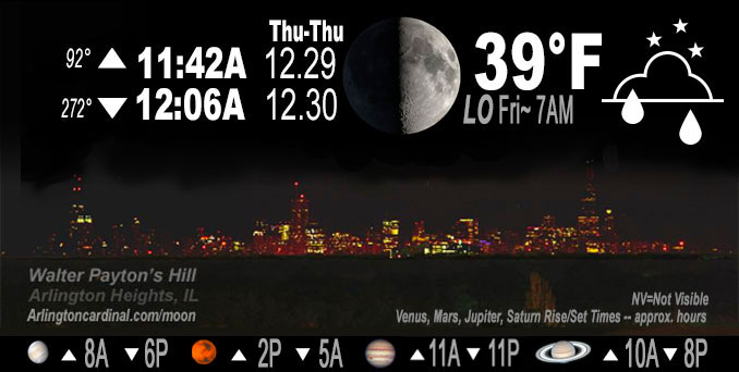
🌓 🌕 🌗 🌑 1st Quarter Moon, sky cover overnight Thu. to Fri. 100% to 81% to 96% to 89%, winds SSW to WSW, 15 to 9 MPH, G29 to 31 to 18 MPH, Low 38, 7a to 12p
NWS CHGO | NWS HRLY | /NWSchicago | 🌡
ARLINGTON HEIGHTS WEATHER
▴ forecast7 (Arl. Hts.) | RADAR | WIDE RADAR
IMPORTANT NOTE ON NWS DATA
======================
NIGHT FORECASTS …
NOTE 1: Forecast and information text below may refer to a previous night on Arlingtoncardinal.com, and might not be updated until late afternoon, evening, or overnight. However, Night Sky archives on CARDINAL NEWS Magazine include text forecasts that correspond to the lunar phase graphic above.
NOTE 2: Keep in mind lunar rise and set times don’t always correspond with night weather and early morning lows because on some days during the month the moon is visible in the sky predominantly during the daytime hours.
Overnight Thursday/Friday …
Weather Hazards expected …
Limited Non Thunderstorm Wind Risk.
DISCUSSION…
Milder temperatures will continue after sunset but will begin to drop just after midnight and continue to drop all day Friday. Expect 55°F at midnight, and 38°F by 8:00 a.m. A high of only 39°F from 1:00 p.m. to 3:00 p.m. Friday. A cold front is approaching from Iowa.
Southerly flow will end just after midnight with winds from the west southwest overnight.
Hello mobile users! If you encounter mobile “unfriendly” weather page, turn your phone sideways for a better view.
======================
O’HARE FORECAST …
Forecast Beginning Thursday Night, Dec. 29, 2022 …
Thursday Night: Showers likely, mainly between midnight and 2am. Cloudy, with a low around 40. Breezy, with a south wind 10 to 20 mph, with gusts as high as 30 mph. Chance of precipitation is 60%. New precipitation amounts of less than a tenth of an inch possible.
Friday: Cloudy, with a temperature falling to around 38 by 4pm. West wind 5 to 10 mph, with gusts as high as 15 mph.
Friday Night: Mostly cloudy, with a low around 30. West wind around 5 mph becoming calm in the evening.
Saturday: Partly sunny, with a high near 40. North northeast wind around 5 mph becoming southeast in the afternoon.
Saturday Night: A 40 percent chance of rain. Mostly cloudy, with a low around 33.
New Year’s Day: Partly sunny, with a high near 44.
Sunday Night: Mostly cloudy, with a low around 34.
Monday: A chance of showers after 3pm. Cloudy, with a high near 50.
Monday Night: Rain. Cloudy, with a low around 48.
Tuesday: A chance of rain. Mostly cloudy, with a high near 57. Breezy.
Tuesday Night: Mostly cloudy, with a low around 33.
Wednesday: Mostly cloudy, with a high near 36.
O’Hare forecast archive and hourly weather observations archive are available HERE on the CARDINAL NEWS Magazine.
Arlingtoncardinal.com/moonphases
Arlingtoncardinal.com/nightsky
NIGHT SKY THIS MONTH …
Check the night sky objects for this month and past months in the playlist from the Space Telescope Science Institute YouTube channel Backyard stargazers get a monthly guide to the northern hemisphere’s skywatching events with “Tonight’s Sky” (Musical track The Far River written by Jonn Serrie, from the album And the Stars Go With You courtesy of New World Music Ltd. Musical track The Far River written by Jonn Serrie, from the album And the Stars Go With You courtesy of New World Music Ltd).
Telephoto lens, ISO 100, f/11, Shutter Speed 1/100 to 1/125 for the Moon.
Get updates from The Cardinal ALL NEWS FEEDS on Facebook. Just ‘LIKE’ the ‘Arlington Cardinal Page (become a fan of our page). The updates cover all posts and sub-category posts from The Cardinal — Arlingtoncardinal.com. You can also limit feeds to specific categories. See all of The Cardinal Facebook fan pages at Arlingtoncardinal.com/about/facebook …
Help fund The Cardinal Arlingtoncardinal.com/sponsor
Telephoto lens, ISO 1600, f/11, Shutter Speed 2.5″ for the skyline. The skyline exposure was toned down, and brightness and contrast was adjusted in Photoshop.
Area Forecast Discussion
National Weather Service Chicago/Romeoville, IL
1044 PM CST Thu Dec 29 2022
.UPDATE… Issued at 859 PM CST Thu Dec 29 2022
A recent surface hand analyses places a surface low pressure system centered near La Crosse, Wisconsin with a trailing cold front through central Iowa, western Missouri, and central Oklahoma. A surface dryline extends southward from the low along the Mississippi River, with a warm front draped from central Wisconsin into northern Lower Michigan. Ahead of the dryline, the airmass is seasonably moist with surface dew points in the low to mid-50s and PWATs ranging from 0.6 to 0.8″. Surface temperatures are likewise in the low to mid 50s, which is some 20 to 25 degrees above average for this time of year and day!
Over the next few hours, the aforementioned cold front is expected to catch up to the dry line while entering western Illinois. At the same time, the diffluent right-entrance region of an elongated 135-140kt 250mb jet streak currently stretching from central Kansas to northern Wisconsin is expected to lift northeastward into the lower Great Lakes. Taken together, a band of showers is expected to develop ahead of the consolidating surface boundaries and shift northeastward more or less along Interstate 55 between about 11 PM and 3 AM. With steep mid-level lapse rates in place (e.g. 8.0 K/Km from 850-500mb sampled by the 00Z ILX RAOB) and locally pooled low-level moisture characterized by surface dew points of 55-56 degrees along and ahead of the front, MUCAPE values range from 200 to 400 J/kg across western Illinois. As a result, it would not be surprising at all for a few thunderstorms to develop along the front as well, again favoring areas along and east of I-55. The greatest threat with any thunderstorm would be a brief downpour and a cloud to ground lightning strike.
Updated products have been sent.
Borchardt/NWS Chicago
