
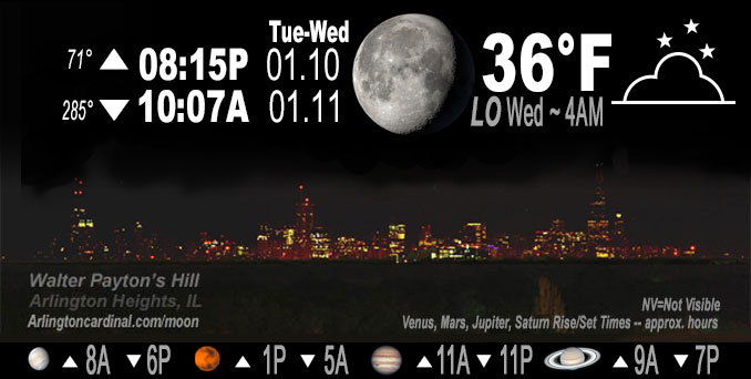
🌖 🌗 🌑 🌓 Waning Gibbous Moon, sky cover overnight Tue. to Wed. 32% to 93% to 76%, winds SSW to SSE to SE, 6 to 2 to 3 MPH, Low 36, 4a to 6a
NWS CHGO | NWS HRLY | /NWSchicago | 🌡
ARLINGTON HEIGHTS WEATHER
▴ forecast7 (Arl. Hts.) | RADAR | WIDE RADAR
IMPORTANT NOTE ON NWS DATA
======================
NIGHT FORECASTS …
NOTE 1: Forecast and information text below may refer to a previous night on Arlingtoncardinal.com, and might not be updated until late afternoon, evening, or overnight. However, Night Sky archives on CARDINAL NEWS Magazine include text forecasts that correspond to the lunar phase graphic above.
NOTE 2: Keep in mind lunar rise and set times don’t always correspond with night weather and early morning lows because on some days during the month the moon is visible in the sky predominantly during the daytime hours.
Overnight Tuesday/Wednesday …
No Weather Hazards expected …
Keep on the lookout for patchy fog. High dew points (mid- upper 30s) and long nights, may overcome the mid-high cloudiness that reduces fog risk. NWS Chicago is planning to carry some patchy fog in the grids Tuesday night into early Wednesday morning, though confidence is low that widespread dense fog will develop.
DISCUSSION…
Weather reminiscent of early spring rather than the heart of winter. For those that love the warmth, mid-high level cloudiness will overspread the area Tuesday night, which will lower the radiational cooling rate overnight. Tonight’s low temperature in Arlington Heights and nearby communities is forecast to hold above 35°F. The clouds are arriving in advance of a weak shortwave trough passing to our north.
Hello mobile users! If you encounter mobile “unfriendly” weather page, turn your phone sideways for a better view.
======================
O’HARE FORECAST …
Forecast Beginning Tuesday Night, Jan. 10, 2023 …
Tuesday Night: Increasing clouds, with a low around 35. South wind around 5 mph becoming calm in the evening.
Wednesday: Mostly cloudy, with a high near 47. Calm wind becoming southeast around 5 mph in the morning.
Wednesday Night: A 30 percent chance of rain after midnight. Cloudy, with a low around 37. South southeast wind 5 to 10 mph becoming north northwest in the evening. Winds could gust as high as 15 mph.
Thursday: Rain likely before noon, then a chance of rain and snow. Cloudy, with a high near 38. North wind 10 to 15 mph, with gusts as high as 25 mph. Chance of precipitation is 60%. New snow accumulation of less than a half inch possible.
Thursday Night: A slight chance of rain and snow before 9pm, then a slight chance of snow. Cloudy, with a low around 29. North northwest wind around 15 mph, with gusts as high as 25 mph. Chance of precipitation is 20%.
Friday: Mostly cloudy, with a high near 33.
Friday Night: Partly cloudy, with a low around 23.
Saturday: Sunny, with a high near 36.
Saturday Night: Mostly cloudy, with a low around 30.
Sunday: Mostly cloudy, with a high near 42.
Sunday Night: Cloudy, with a low around 38.
M.L.King Day: Rain likely. Cloudy, with a high near 46.
Monday Night: A chance of rain. Cloudy, with a low around 38.
Tuesday: A chance of rain. Mostly cloudy, with a high near 44.
O’Hare forecast archive and hourly weather observations archive are available HERE on the CARDINAL NEWS Magazine.
Arlingtoncardinal.com/moonphases
Arlingtoncardinal.com/nightsky
NIGHT SKY THIS MONTH …
Check the night sky objects for this month and past months in the playlist from the Space Telescope Science Institute YouTube channel Backyard stargazers get a monthly guide to the northern hemisphere’s skywatching events with “Tonight’s Sky” (Musical track The Far River written by Jonn Serrie, from the album And the Stars Go With You courtesy of New World Music Ltd. Musical track The Far River written by Jonn Serrie, from the album And the Stars Go With You courtesy of New World Music Ltd).
Telephoto lens, ISO 100, f/11, Shutter Speed 1/100 to 1/125 for the Moon.
Get updates from The Cardinal ALL NEWS FEEDS on Facebook. Just ‘LIKE’ the ‘Arlington Cardinal Page (become a fan of our page). The updates cover all posts and sub-category posts from The Cardinal — Arlingtoncardinal.com. You can also limit feeds to specific categories. See all of The Cardinal Facebook fan pages at Arlingtoncardinal.com/about/facebook …
Help fund The Cardinal Arlingtoncardinal.com/sponsor
Telephoto lens, ISO 1600, f/11, Shutter Speed 2.5″ for the skyline. The skyline exposure was toned down, and brightness and contrast was adjusted in Photoshop.
Area Forecast Discussion
National Weather Service Chicago/Romeoville, IL
307 PM CST Tue Jan 10 2023
.SHORT TERM… Issued at 238 PM CST Tue Jan 10 2023
Through Wednesday night…
Today`s weather is much more reminiscent of early spring than the heart of winter. Skies are mostly sunny and temps have warmed into the 40s to around 50 and will probably inch up another couple degrees this afternoon. In true Chicago spring-like fashion, a weak lake breeze has formed this afternoon resulting in temps nearly 10F cooler right along the shore.
Extensive mid-high level cloudiness will overspread the area this evening in advance of a weak shortwave trough passing to our north. This cloudiness will low the radiational cooling rate, but will it be enough to prevent radiation fog from developing? Given the high dewpoints (mid- upper 30s) and long nights, am concerned that the mid-high cloudiness alone may not be enough to eliminate the fog risk. Planning to carry some patchy fog in the grids tonight into early Wednesday morning, though confidence is low in how dense and widespread fog will become.
An even more moist air mass looks to advect into the area from the south on Wednesday as lee cyclogenesis gets underway. This renewed push of moisture should be accompanied by an expanding stratus deck and perhaps some fog. Forecast time-height cross sections across our southern CWA do show a brief period (an hour or two) where forcing and depth of moisture could be sufficient for a bit of drizzle, but more often than not guidance ends up too aggressive in these scenarios. Some advection fog is possible and cannot rule out some dense fog, but confidence is low at this time. Despite more cloud cover, much higher theta-e air mass should allow for highs well into the 40s again. Synoptically, winds will turn easterly tomorrow, so some modest lake cooling is expected once again.
Rain associated with the next system should begin to spread across mainly southern portions of the forecast area late Wednesday night. At this point, it looks like precipitation should remain south of where the atmosphere will be cold enough to produce any mix or snow.
– Izzi/NWS Chicago
