
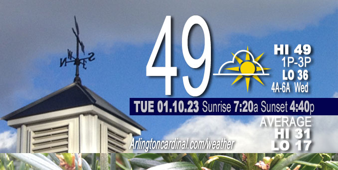
Tuesday Hi 49, partly cloudy, winds S to SW to SSW, 5 to 6 to 3 MPH
NWS CHGO | NWS HRLY | /NWSchicago | 🌡
ARLINGTON HEIGHTS WEATHER
▴ forecast7 (Arl. Hts.) | RADAR | WIDE RADAR
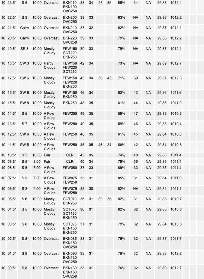
⏪ Hrly Data Table | Hrly Future Graph ⏩
IMPORTANT NOTE ON NWS DATA
⏪ Hrly Data Table | Hrly Future Graph ⏩
======================
Tuesday and Tuesday Night …
No Weather Hazards expected…
Limited Fog Risk this morning.
DISCUSSION…
There has been a notable trend in forecast guidance in that the arrival of a weak cold front has trended considerably slower. Twenty-four hours ago, it looked like the front would be entering our northwestern counties sometime Monday morning, but now, it appears that the cold front may not reach our CWA until this evening.
======================
O’HARE FORECAST …
Forecast Beginning Tuesday, Jan. 10, 2023
O’HARE FORECAST …
Tuesday: Sunny, with a high near 48. Southwest wind around 5 mph.
Tuesday Night: Increasing clouds, with a low around 35. South wind around 5 mph becoming calm in the evening.
Wednesday: Mostly cloudy, with a high near 47. Calm wind becoming southeast around 5 mph in the morning.
Wednesday Night: A 30 percent chance of rain after midnight. Cloudy, with a low around 37. South southeast wind 5 to 10 mph becoming north northwest in the evening. Winds could gust as high as 15 mph.
Thursday: Rain likely before noon, then a chance of rain and snow. Cloudy, with a high near 38. North wind 10 to 15 mph, with gusts as high as 25 mph. Chance of precipitation is 60%.
Thursday Night: A slight chance of rain and snow before 9pm, then a slight chance of snow. Cloudy, with a low around 29. Chance of precipitation is 20%.
Friday: Mostly cloudy, with a high near 33.
Friday Night: Partly cloudy, with a low around 23.
Saturday: Sunny, with a high near 36.
Saturday Night: Mostly cloudy, with a low around 30.
Sunday: Mostly cloudy, with a high near 42.
Sunday Night: Cloudy, with a low around 38.
M.L.King Day: Rain likely. Cloudy, with a high near 46.


CHICAGOWEATHERSTATION.COM

ChicagoWeatherStation.com I O’Hare Normal Temps/Precip I O’Hare Record Temps, Precip, Snow
LIVE RADAR | STORM TRACKS | UNISYS US IR SAT | UNISYS Midwest IR SAT | UNISYS More IR SAT
WunderMap® with Temperature/Wind Data || Google: Arlington Heights Area Temps | US TEMPS
Full Screen Motion Weather Radar (Wunderground.com)
Midwest Cloud Cover with Arlington Heights Weather Forecast
ChicagoWeatherStation.com I O’Hare Normal Temps/Precip I O’Hare Record Temps, Precip, Snow
SUNLIGHT DATA FOR SECURITY, TRAFFIC SAFETY, AND SPORTS
SunCalc.net data with solar azimuth and trajectory, times for dawn, sunrise, solar noon, sunset, dusk …
NIGHT SKY THIS MONTH …
Backyard stargazers get a monthly guide to the northern hemisphere’s skywatching events with “Tonight’s Sky.” Check the night sky objects for this month and past months in the playlist from the Space Telescope Science Institute YouTube channel (Musical track The Far River written by Jonn Serrie, from the album And the Stars Go With You courtesy of New World Music Ltd).
Get updates from The Cardinal ALL NEWS FEEDS on Facebook. Just ‘LIKE’ the ‘Arlington Cardinal Page (become a fan of our page). The updates cover all posts and sub-category posts from The Cardinal — Arlingtoncardinal.com. You can also limit feeds to specific categories. See all of The Cardinal Facebook fan pages at Arlingtoncardinal.com/about/facebook …
Help fund The Cardinal Arlingtoncardinal.com/sponsor
Area Forecast Discussion
National Weather Service Chicago/Romeoville, IL
526 AM CST Tue Jan 10 2023
.SHORT TERM… Issued at 335 AM CST Tue Jan 10 2023
Through Wednesday…
Early morning surface analysis reveals the center of a weak surface low pressure area to be just east of the Twin Cities at press time with a weak cold front draped to the south of there over northern Iowa. Aloft, a fairly pronounced shortwave trough is pushing through the region with an expansive shield of mid/high-level cloud cover translating over the southern Great Lakes ahead of it. This cloud deck is in the process of deepening, and the expectation is that some hydrometeors will begin to descend from this deck over the next few hours. Have indeed begun to see an uptick in high-based radar echoes over northwest Indiana over the past hour, and would not be surprised to see some raindrops make it to the ground here prior to daybreak, but not really expecting anything more than that with the remainder of our forecast area expected to remain dry this morning.
As for the remainder of today, there has been a notable trend in forecast guidance in that the arrival of the aforementioned weak cold front has trended considerably slower. Twenty-four hours ago, it looked like the front would be entering our northwestern counties sometime this morning, but now, it appears that the front may not reach our CWA until this evening. This has several ramifications for our forecast today as the post-frontal air mass that is engulfing southern Minnesota is infested with low stratus, fog, and possibly some drizzle as well that may have otherwise been seen in at least some portions of our forecast area today alongside cooler temperatures if the front had indeed been more progressive. Instead, with the delayed arrival of the frontal passage, today`s fog and drizzle chances have effectively been rendered null and void, and with the associated delayed arrival of both low and high cloud cover, we should see a lot of the Sun for a second consecutive day, which will allow for daytime temperatures to climb well into the 40s with even some low 50 degree readings seemingly attainable in our southern counties and possibly even in the heart of the Chicago metro urban heat island.
Another gradually thickening mid/high-level cloud deck will pass overhead later this afternoon and into tonight in advance of yet another shortwave impulse. Forecast soundings and modeled composite radar reflectivity suggest that hydrometeors will likely be leaking out of this cloud deck as it moves over northern Illinois and northwest Indiana, but a large wedge of dry mid-level air should all but guarantee that this ends up being nothing more than virga here locally. Both this cloud deck and any lower cloud cover that moves in behind the aforementioned front tonight will limit the degree of nocturnal cooling that we`ll see with low temperatures Tuesday night into Wednesday morning currently pegged to end up in the low-mid 30s area-wide.
Then on Wednesday, the front will lift northward, and we`ll begin to find ourselves in the midst of a warm air advection/isentropic ascent regime as a low-level theta-e ridge builds northward into the region ahead of a developing low pressure system in the central/southern Plains. Most guidance is in fair agreement that low-level moisture profiles will end up being at least marginally supportive of drizzle development in portions of central Illinois and Indiana, and it appears plausible that this deeper moisture could ooze far enough northward for some locales in our forecast area to see drizzle and/or fog Wednesday morning and afternoon. Confidence in that occurring is currently low-medium, but there seems to be enough support amongst the broader suite of forecast guidance to warrant the addition of some slight chance PoPs for drizzle and a patchy fog mention to our forecast grids, so did go ahead and do that for areas along and south of the Kankakee River Valley and through most of northwest Indiana, where confidence is highest in the more favorable moisture profiles being realized. However, could certainly foresee needing to increase PoPs farther north/northwest in our CWA in forthcoming forecast packages with some of the more moisture-bullish models outputting QPF as far north as Wisconsin. Either way, Wednesday should feature highs in the 40s again, as well as the return of much more abundant low cloud cover.
Ogorek/NWS Chicago
