
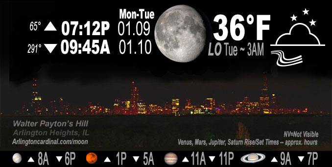
🌖 🌗 🌑 🌓 Waning Gibbous Moon, sky cover overnight Mon. to Tue. 66% to 92% to 33%, winds SSW to SW, 8 to 9 to 7 MPH, G13 to 15 to 13MPH, Low 36, 5a to 8a
NWS CHGO | NWS HRLY | /NWSchicago | 🌡
ARLINGTON HEIGHTS WEATHER
▴ forecast7 (Arl. Hts.) | RADAR | WIDE RADAR
IMPORTANT NOTE ON NWS DATA
======================
NIGHT FORECASTS …
NOTE 1: Forecast and information text below may refer to a previous night on Arlingtoncardinal.com, and might not be updated until late afternoon, evening, or overnight. However, Night Sky archives on CARDINAL NEWS Magazine include text forecasts that correspond to the lunar phase graphic above.
NOTE 2: Keep in mind lunar rise and set times don’t always correspond with night weather and early morning lows because on some days during the month the moon is visible in the sky predominantly during the daytime hours.
Overnight Monday/Tuesday …
Weather Hazards expected …
Low confidence, but freezing drizzle and/or fog is possible
DISCUSSION…
All in all, the puzzle pieces for Tuesday morning`s precipitation potential just don`t seem to match up well enough at this point to warrant the slight chance precipitation category, so 10-14% PoPs across much of Chicagoland early in the game. Depending on the timing of the cold front`s arrival, it`s possible that surface temperatures will be near or below freezing, resulting in a non- zero threat of freezing drizzle Tuesday morning. Watch out for the potential for fog again Tuesday morning behind the cold front.
Hello mobile users! If you encounter mobile “unfriendly” weather page, turn your phone sideways for a better view.
======================
O’HARE FORECAST …
Forecast Beginning Monday Night, Jan. 09, 2023 …
Monday Night*: 66% cloud cover increasing overnight, low 36. South-southwest wind around 8 to 9 mph with gusts 15 mph to 13 mph.
Tuesday: Sunny, with a high near 48. Southwest wind around 5 mph.
Tuesday Night: Increasing clouds, with a low around 35. South wind around 5 mph becoming calm in the evening.
Wednesday: Mostly cloudy, with a high near 47. Calm wind becoming southeast around 5 mph in the morning.
Wednesday Night: A 30 percent chance of rain after midnight. Cloudy, with a low around 37. South southeast wind 5 to 10 mph becoming north northwest in the evening. Winds could gust as high as 15 mph.
Thursday: Rain likely before noon, then a chance of rain and snow. Cloudy, with a high near 38. North wind 10 to 15 mph, with gusts as high as 25 mph. Chance of precipitation is 60%.
Thursday Night: A slight chance of rain and snow before 9pm, then a slight chance of snow. Cloudy, with a low around 29. Chance of precipitation is 20%.
Friday: Mostly cloudy, with a high near 33.
Friday Night: Partly cloudy, with a low around 23.
Saturday: Sunny, with a high near 36.
Saturday Night: Mostly cloudy, with a low around 30.
Sunday: Mostly cloudy, with a high near 42.
Sunday Night: Cloudy, with a low around 38.
M.L.King Day: Rain likely. Cloudy, with a high near 46.
* Forecast ‘reconstructed’ after the fact on for Monday night, remainder published from Tuesday’s forecast.
O’Hare forecast archive and hourly weather observations archive are available HERE on the CARDINAL NEWS Magazine.
Arlingtoncardinal.com/moonphases
Arlingtoncardinal.com/nightsky
NIGHT SKY THIS MONTH …
Check the night sky objects for this month and past months in the playlist from the Space Telescope Science Institute YouTube channel Backyard stargazers get a monthly guide to the northern hemisphere’s skywatching events with “Tonight’s Sky” (Musical track The Far River written by Jonn Serrie, from the album And the Stars Go With You courtesy of New World Music Ltd. Musical track The Far River written by Jonn Serrie, from the album And the Stars Go With You courtesy of New World Music Ltd).
Telephoto lens, ISO 100, f/11, Shutter Speed 1/100 to 1/125 for the Moon.
Get updates from The Cardinal ALL NEWS FEEDS on Facebook. Just ‘LIKE’ the ‘Arlington Cardinal Page (become a fan of our page). The updates cover all posts and sub-category posts from The Cardinal — Arlingtoncardinal.com. You can also limit feeds to specific categories. See all of The Cardinal Facebook fan pages at Arlingtoncardinal.com/about/facebook …
Help fund The Cardinal Arlingtoncardinal.com/sponsor
Telephoto lens, ISO 1600, f/11, Shutter Speed 2.5″ for the skyline. The skyline exposure was toned down, and brightness and contrast was adjusted in Photoshop.
Area Forecast Discussion
National Weather Service Chicago/Romeoville, IL
1028 PM CST Mon Jan 9 2023
.SHORT TERM… Issued at 140 PM CST Mon Jan 9 2023
Through Tuesday night…
A mild winter afternoon is underway across northeastern Illinois and northwest Indiana courtesy of the northern periphery of a broad surface high residing over the southern Mississippi Valley. The south-southwesterly flow in combination with the mostly sunny skies have allowed temperatures to warm into the upper 30s and lower 40s so far this afternoon with another degree or two of warming expected before all is said and done. Unfortunately cloud cover will begin to increase through the afternoon and evening as mid-level moisture increases ahead of an upper-level disturbance currently moving southeastward across the northern Plains. While this cloud cover is expected to linger through our Tuesday, it does look to kee Ptemperatures on the milder side with overnight lows in the low to mid 30s tonight and highs on Tuesday in the upper 30s to lower 40s once again.
In addition to the increasing cloud cover this evening there is also the potential for some sprinkles late this evening into Tuesday morning as the aforementioned upper-level disturbance moves through. Confidence in any sprinkles being observed continues to be on the lower side as forecast soundings are showing a robust dry layer in the low-levels that would need to be overcome before precipitation would reach the ground. While some guidance does show this layer saturating with time, the window where the better forcing and moisture align looks to be rather short which may lead to most areas remaining dry through the night. However, I did feel that there was at least enough of a signal to add in a sprinkle mention for areas northeast of a Rockford to Kankakee line where better moisture profiles look to set up.
Any sprinkles that do develop are expected to come to an end Tuesday morning as a weak frontal boundary swings through the area. While the aforementioned cloud cover will continue to persist behind this front precipitation chances do look to remain low through Tuesday night. However, some guidance is trying to spit out some drizzle and fog Tuesday night as warm advection begins to take hold but forecast soundings continue to show that the low-level moisture profile to be rather shallow which may make it difficult for any drizzle or fog to develop under the lingering stratus. For now I have maintained a dry forecast for Tuesday night, but forecast trends will need to be monitored to see if a drizzle and/or fog mention is needed with future updates.
Yack/NWS Chicago
