
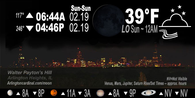
🌘 🌑 🌗 🌕 Waning Crescent Moon, sky cover overnight Sat. to Sun. 100% to 53%, winds S to SW, 6 to 16 to 15 MPH, G20 to 25 to 24 MPH, Low 39, 12a to 1a
NWS CHGO | NWS HRLY | /NWSchicago | 🌡
ARLINGTON HEIGHTS WEATHER
▴ forecast7 (Arl. Hts.) | RADAR | WIDE RADAR
IMPORTANT NOTE ON NWS DATA
======================
NIGHT FORECASTS …
NOTE: Keep in mind lunar rise and set times don’t always correspond with night weather and early morning lows because on some days during the month the moon is visible in the sky predominantly during the daytime hours.
Overnight Saturday/Sunday …
No Weather Hazards expected
Gusty winds overnight up to 20 to 25 MPH.
DISCUSSION…
Sprinkles possible. The warm advection generated by the aforementioned winds in combination with a weak upper-level disturbance sliding overhead is also generating a broad area of mid-level clouds and possible virga. Radar continues to show an area of 10 to 20 dbz echoes moving across central and northwestern Illinois, but ground stations have not reported any precipitation as of yet due to the dry layer below the cloud bases as noted in recent aircraft soundings.
Hello mobile users! If you encounter mobile “unfriendly” weather page, turn your phone sideways for a better view.
======================
O’HARE FORECAST …
Forecast Beginning Saturday Night, Feb. 18, 2023 …
Saturday Night: A chance of sprinkles. Cloudy, with a low around 35. South southwest wind around 15 mph, with gusts as high as 25 mph.
Sunday: Mostly sunny, with a high near 47. Breezy, with a south southwest wind 15 to 20 mph, with gusts as high as 30 mph.
Sunday Night: Mostly cloudy, with a low around 30. West wind 5 to 10 mph becoming north northwest after midnight. Winds could gust as high as 20 mph.
Monday Washington’s Birthday: Partly sunny, with a high near 43. Northwest wind 5 to 10 mph becoming south in the morning. Winds could gust as high as 15 mph.
Monday Night: Partly cloudy, with a low around 32. South southwest wind 10 to 15 mph becoming west after midnight. Winds could gust as high as 30 mph.
Tuesday: Mostly sunny, with a high near 38.
Tuesday Night: A 30 percent chance of rain after midnight. Mostly cloudy, with a low around 32.
Wednesday: A chance of rain and snow before noon, then rain. Cloudy, with a high near 38. Breezy.
Wednesday Night: Rain. Cloudy, with a low around 35. Breezy.
Thursday: A chance of rain. Mostly cloudy, with a high near 47. Breezy.
Thursday Night: Mostly cloudy, with a low around 20. Breezy.
Friday: Partly sunny, with a high near 32.
Friday Night: A chance of snow. Mostly cloudy, with a low around 29.
Saturday: Mostly cloudy, with a high near 40.
O’Hare forecast archive and hourly weather observations archive are available HERE on the CARDINAL NEWS Magazine.
Arlingtoncardinal.com/moonphases
Arlingtoncardinal.com/nightsky
NIGHT SKY THIS MONTH …
Check the night sky objects for this month and past months in the playlist from the Space Telescope Science Institute YouTube channel Backyard stargazers get a monthly guide to the northern hemisphere’s skywatching events with “Tonight’s Sky” (Musical track The Far River written by Jonn Serrie, from the album And the Stars Go With You courtesy of New World Music Ltd. Musical track The Far River written by Jonn Serrie, from the album And the Stars Go With You courtesy of New World Music Ltd).
Telephoto lens, ISO 100, f/11, Shutter Speed 1/100 to 1/125 for the Moon.
Get updates from The Cardinal ALL NEWS FEEDS on Facebook. Just ‘LIKE’ the ‘Arlington Cardinal Page (become a fan of our page). The updates cover all posts and sub-category posts from The Cardinal — Arlingtoncardinal.com. You can also limit feeds to specific categories. See all of The Cardinal Facebook fan pages at Arlingtoncardinal.com/about/facebook …
Help fund The Cardinal Arlingtoncardinal.com/sponsor
Telephoto lens, ISO 1600, f/11, Shutter Speed 2.5″ for the skyline. The skyline exposure was toned down, and brightness and contrast was adjusted in Photoshop.
Area Forecast Discussion
National Weather Service Chicago/Romeoville, IL
326 AM CST Sun Feb 19 2023
.SHORT TERM… Issued at 325 AM CST Sun Feb 19 2023
Through Monday…
Northeastern Illinois and northwest Indiana continues to be sandwiched between a broad surface high over the southeastern CONUS and a developing surface low over the upper Midwest which is creating breezy southerly winds across the area this morning. Gusts of 20 to 25 mph are being reported across the area and are expected to continue through daybreak then increase as the atmosphere begins to mix into the base of a 40 kt low-level jet. This will generate gusts upwards of 30 mph through the early part of the afternoon before winds gradually ease heading into the evening behind a weak cold front.
Additionally, the warm advection generated by the aforementioned winds in combination with a weak upper-level disturbance sliding overhead is also generating a broad area of mid-level clouds and possible virga. Radar continues to show an area of 10 to 20 dbz echoes moving across central and northwestern Illinois, but ground stations have not reported any precipitation as of yet due to the dry layer below the cloud bases as noted in recent aircraft soundings. While I do not suspect we will see much of anything from these echoes as they continue to move northeastward across the area, I did maintain a chance of sprinkles in the forecast through daybreak just in case.
The mid-level clouds are expected to clear the area later this morning which will leave us under mostly sunny skies for our Sunday afternoon before clouds increase behind the aforementioned cold front this evening. The combination of sunshine and warm advection should allow temperatures to climb into the mid to upper 40s and lower 50s areawide this afternoon. While the cold front will briefly turn winds northwesterly this evening and cool temperatures into the upper 20s and lower 30s tonight, south-southwesterly flow is expected to redevelop during the day on Monday which should allow temperatures to rebound into the 40s to near 50 degrees despite the increased cloud cover.
Yack/NWS Chicago
