
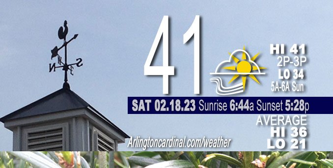
Saturday Hi 41, mostly sunny to partly cloudy, winds SW to S to SSW, 11 to 7 to 15 MPH, G22 to 14 to 25 MPH increasing slightly Sunday
NWS CHGO | NWS HRLY | /NWSchicago | 🌡
ARLINGTON HEIGHTS WEATHER
▴ forecast7 (Arl. Hts.) | RADAR | WIDE RADAR
⏪ Hrly Data Table | Hrly Future Graph ⏩
IMPORTANT NOTE ON NWS DATA
⏪ Hrly Data Table | Hrly Future Graph ⏩
======================
Saturday and Saturday Evening …
No Weather Hazards expected …
There is a chance of sprinkles late tonight around midnight into early Sunday morning as a quick moving upper-level disturbance passes through the area. [Sprinkles were probably only virga; no ground reports, just radar.]
DISCUSSION…
While the winds will add to the chilly feeling outside this morning, the southwest winds will continue to advect in warmer air to the region creating mild temperatures for the weekend. Highs today are expected to top out in the low to mid 40s for many locations but the lingering snow pack across far northern Illinois looks to keep temperatures a few degrees cooler in the upper 30s. Saturday/Sunday low temperature forecast to stay above freezing.
Daily low temperatures and daily high temperatures are on the way up. We’re gaining about 2 minutes of daylight every day in the progression toward vernal equinox, March 20, 2023.
======================
O’HARE FORECAST …
Forecast Beginning Saturday, Feb. 18, 2023
Saturday: Mostly sunny, with a high near 41. Southwest wind 5 to 10 mph, with gusts as high as 20 mph.
Saturday Night: A chance of sprinkles after midnight. Mostly cloudy, with a low around 34. South southwest wind 5 to 15 mph, with gusts as high as 25 mph.
Sunday: Mostly sunny, with a high near 48. South southwest wind around 15 mph, with gusts as high as 30 mph.
Sunday Night: Cloudy, then gradually becoming partly cloudy, with a low around 29. West wind 5 to 15 mph, with gusts as high as 25 mph.
Washington’s Birthday: Partly sunny, with a high near 41. West northwest wind 5 to 10 mph becoming south in the afternoon.
Monday Night: Mostly cloudy, with a low around 30.
Tuesday: Partly sunny, with a high near 40.
Tuesday Night: Mostly cloudy, with a low around 32.
Wednesday: Rain likely after noon. Cloudy, with a high near 39. Breezy.
Wednesday Night: Rain. Cloudy, with a low around 34. Breezy.
Thursday: A chance of rain. Mostly cloudy, with a high near 49. Breezy.
Thursday Night: Partly cloudy, with a low around 17. Breezy.
Friday: Partly sunny, with a high near 30.


CHICAGOWEATHERSTATION.COM

ChicagoWeatherStation.com I O’Hare Normal Temps/Precip I O’Hare Record Temps, Precip, Snow
LIVE RADAR | STORM TRACKS | UNISYS US IR SAT | UNISYS Midwest IR SAT | UNISYS More IR SAT
WunderMap® with Temperature/Wind Data || Google: Arlington Heights Area Temps | US TEMPS
Full Screen Motion Weather Radar (Wunderground.com)
Midwest Cloud Cover with Arlington Heights Weather Forecast
ChicagoWeatherStation.com I O’Hare Normal Temps/Precip I O’Hare Record Temps, Precip, Snow
SUNLIGHT DATA FOR SECURITY, TRAFFIC SAFETY, AND SPORTS
SunCalc.net data with solar azimuth and trajectory, times for dawn, sunrise, solar noon, sunset, dusk …
NIGHT SKY THIS MONTH …
Backyard stargazers get a monthly guide to the northern hemisphere’s skywatching events with “Tonight’s Sky.” Check the night sky objects for this month and past months in the playlist from the Space Telescope Science Institute YouTube channel (Musical track The Far River written by Jonn Serrie, from the album And the Stars Go With You courtesy of New World Music Ltd).
Get updates from The Cardinal ALL NEWS FEEDS on Facebook. Just ‘LIKE’ the ‘Arlington Cardinal Page (become a fan of our page). The updates cover all posts and sub-category posts from The Cardinal — Arlingtoncardinal.com. You can also limit feeds to specific categories. See all of The Cardinal Facebook fan pages at Arlingtoncardinal.com/about/facebook …
Help fund The Cardinal Arlingtoncardinal.com/sponsor
Area Forecast Discussion
National Weather Service Chicago/Romeoville, IL
508 AM CST Sat Feb 18 2023
.SHORT TERM… Issued at 158 AM CST Sat Feb 18 2023
Through Sunday…
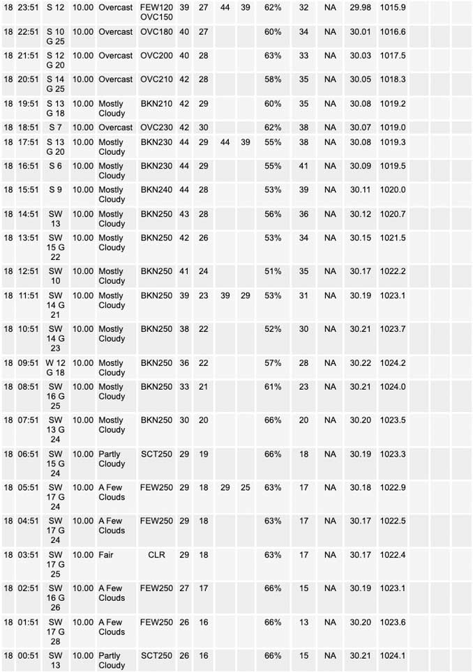
The northern periphery of a broad surface high over the southern CONUS resides across our area this morning leading to the quiet and clear conditions. The position of this surface high and a stout surface low over the southern portion of Hudson Bay, has developed breezy southwesterly winds across much of the Midwest due to the tight pressure gradient. These breezy conditions will continue through our Saturday morning with gusts around 20 to 25 mph before winds ease a bit this afternoon. However, the lull in winds is expected to be brief as a second surface low is expected to develop across the upper Midwest this evening which will re- tighten the pressure gradient and increase winds heading into Sunday morning with gusts in 25 to 30 mph range.
While the winds will add to the chilly feeling outside this morning, the southwest winds will continue to advect in warmer air to the region creating mild temperatures for the weekend. Highs today are expected to top out in the low to mid 40s for many locations but the lingering snow pack across far northern Illinois looks to keep temperatures a few degrees cooler in the upper 30s. These temperatures today should work to diminish the remaining snow pack which will allow temperatures to warm even further on Sunday with highs forecast to be in the upper 40s and lower 50s for most locations. However, some low to mid 40s may still be seen across portions of far northern Illinois if some of the snow pack is able to persist.
Lastly, there is also a chance for some sprinkles late tonight into early Sunday morning as a quick moving upper-level disturbance slides through the area. Forecast soundings continue to show that cloud bases should remain around 10,000 ft with lots of dry air in the subcloud layer. While this should keep most areas from seeing much of anything, I did decided to maintain the sprinkle mention for the entire area just in case some better low- level moisture sneaks in as noted in the global guidance. Otherwise mostly to partly sunny conditions are expected through the weekend.
Yack/NWS Chicago
