
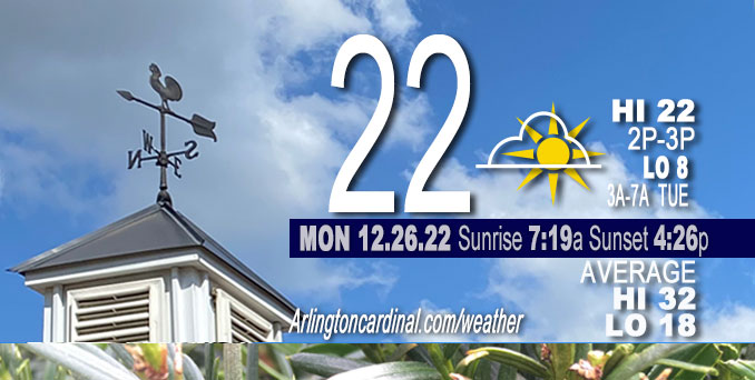
Monday Hi 20-22, light snow ends 12p, mostly cloudy then partly cloudy, winds N to NW to W, 3 to 6 to 5 MPH
NWS CHGO | NWS HRLY | /NWSchicago | 🌡
ARLINGTON HEIGHTS WEATHER
▴ forecast7 (Arl. Hts.) | RADAR | WIDE RADAR
⏪ Hrly Data Table | Hrly Future Graph ⏩
IMPORTANT NOTE ON NWS DATA
⏪ Hrly Data Table | Hrly Future Graph ⏩
======================
Monday and Monday Night …
Weather Hazards expected…
Limited Snow Risk in the morning.
Limited Excessive Cold Risk overnight.
DISCUSSION…
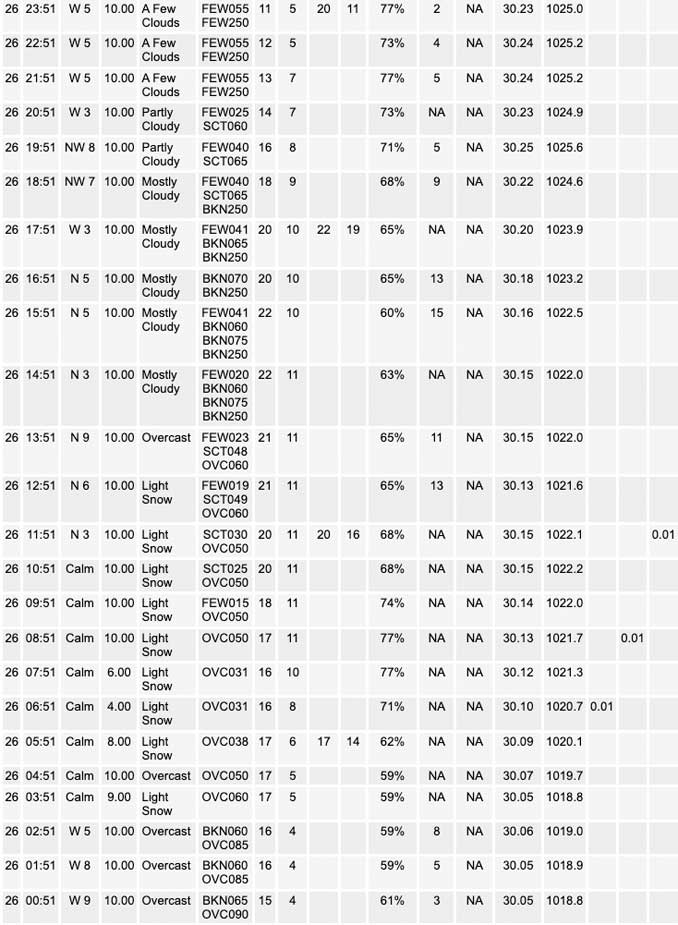
A period of accumulating snow Monday morning was not significant in Arlington Heights. Slick spots on roadways and some hazardous travel was forecast, but accident rates were not high Monday morning.
Temperatures are expected to dip into the single digits Monday night which may lead to some subzero wind chills heading into Tuesday morning. Bundle up before heading out. No wind gust forecast overnight, but gusts will start about 7:00 a.m. Tuesday.
Hello mobile users! If you encounter a mobile “unfriendly” weather page, turn your phone sideways for a better view.
======================
O’HARE FORECAST …
Forecast Beginning Monday, Dec. 26, 2022
Monday: A 40 percent chance of snow, mainly before noon. Cloudy, then gradually becoming mostly sunny, with a high near 21. Calm wind becoming north around 5 mph in the afternoon.
Monday Night: Partly cloudy, with a low around 8. Wind chill values as low as -2. North wind around 5 mph becoming west southwest after midnight. Winds could gust as high as 10 mph.
Tuesday: Mostly sunny, with a high near 25. Wind chill values as low as -4. Southwest wind 5 to 15 mph, with gusts as high as 25 mph.
Tuesday Night: Mostly cloudy, with a low around 22. South southwest wind around 15 mph, with gusts as high as 25 mph.
Wednesday: Partly sunny, with a high near 40. South southwest wind around 15 mph, with gusts as high as 30 mph.
Wednesday Night: Mostly cloudy, with a low around 36.
Thursday: A 20 percent chance of rain after 1pm. Cloudy, with a high near 52.
Thursday Night: A chance of rain after 7pm. Cloudy, with a low around 41.
Friday: A chance of rain. Cloudy, with a high near 49.
Friday Night: Rain likely, mainly after 7pm. Cloudy, with a low around 38.
Saturday: Rain likely. Cloudy, with a high near 46.
Saturday Night: Rain likely. Cloudy, with a low around 37.
New Year’s Day: A chance of rain. Cloudy, with a high near 44.


CHICAGOWEATHERSTATION.COM

ChicagoWeatherStation.com I O’Hare Normal Temps/Precip I O’Hare Record Temps, Precip, Snow
LIVE RADAR | STORM TRACKS | UNISYS US IR SAT | UNISYS Midwest IR SAT | UNISYS More IR SAT
WunderMap® with Temperature/Wind Data || Google: Arlington Heights Area Temps | US TEMPS
Full Screen Motion Weather Radar (Wunderground.com)
Midwest Cloud Cover with Arlington Heights Weather Forecast
ChicagoWeatherStation.com I O’Hare Normal Temps/Precip I O’Hare Record Temps, Precip, Snow
SUNLIGHT DATA FOR SECURITY, TRAFFIC SAFETY, AND SPORTS
SunCalc.net data with solar azimuth and trajectory, times for dawn, sunrise, solar noon, sunset, dusk …
NIGHT SKY THIS MONTH …
Backyard stargazers get a monthly guide to the northern hemisphere’s skywatching events with “Tonight’s Sky.” Check the night sky objects for this month and past months in the playlist from the Space Telescope Science Institute YouTube channel (Musical track The Far River written by Jonn Serrie, from the album And the Stars Go With You courtesy of New World Music Ltd).
Get updates from The Cardinal ALL NEWS FEEDS on Facebook. Just ‘LIKE’ the ‘Arlington Cardinal Page (become a fan of our page). The updates cover all posts and sub-category posts from The Cardinal — Arlingtoncardinal.com. You can also limit feeds to specific categories. See all of The Cardinal Facebook fan pages at Arlingtoncardinal.com/about/facebook …
Help fund The Cardinal Arlingtoncardinal.com/sponsor
Area Forecast Discussion
National Weather Service Chicago/Romeoville, IL
535 AM CST Mon Dec 26 2022
.SHORT TERM… Issued at 259 AM CST Mon Dec 26 2022
Through Tuesday…
The main forecast concern in the short term continues to be the ongoing snow that is expected to create slippery road conditions by daybreak. The upper-level low that is the main driver of the snow is currently moving south-southeastward across central Iowa and is expected to continue this motion as it heads towards central Illinois. Ahead of the low, an area of warm air advection has spread over northeastern Illinois and northwest Indiana which has developed an area of widespread light snow that continues to move eastward across the area. While some stations have reported light snow over the past couple of hours, model analysis soundings indicate that dry air continues to reside in the lower-levels which these initial snow showers will have to saturate.
However, more robust snow showers are being observed on radar over northeastern Iowa where RAP mesoanalysis is showing an area of f-gen forcing around 850 mb that coincides with a strong baroclinic zone in the 850 to 700 mb layer. The baroclinic zone is expected to move southeastward with the low and allow the more robust snow showers to move into northern Illinois over the next few hours. As the low continues its southeastward track into central Illinois it is expected to gradually weaken with time which should keep the stronger snow showers closer to the low where the strongest forcing looks to reside. The cold ground conditions will allow the snow to quickly accumulate with most areas across northeastern Illinois and northwest Indiana expected to pick up around half an inch of snow with higher amounts of up to 1 to possibly 2 inches for areas near the I-39 corridor where the area of better forcing is expected to reside. While these accumulations are minor they will still cause slippery road conditions due to the aforementioned cold ground temperatures so anyone with travel plans this morning is encouraged to use caution and leave extra time to reach your destination.
The low is expected to move south of the area this afternoon which will allow snow to taper off from north to south. While most areas are expected to be dry by the afternoon, guidance is indicating that lingering moisture in the DGZ and weak forcing may allow for some light snow/flurries to persist through this afternoon for areas along and south of the Kankakee River.
Additionally, guidance is also continuing to show an area of enhanced surface convergence developing over southern Lake Michigan behind the low which looks to spark some lake effect snow for portions of northwest Indiana. However, there continues to be some uncertainty in how robust these lake effect bands would be as forecast soundings show that the lake induced instability would be below the DGZ which may limit the intensity. Furthermore, by time the convergence axis develops this afternoon moisture is expected to be waning along with the synoptic scale forcing which may further act to limit intensity of the lake effect snow. At this time I have maintained a slight chance mention for lake effect snow to account for this potential for portions of northwest Indiana through early evening with only minor accumulations of a couple tenths expected.
Once the snow comes to an end late this afternoon/early evening, skies will begin to clear out as the northern periphery of a surface high over the southern plains moves into the area. The clearing skies will allow temperatures to dip into the single digits tonight, but strengthening southerly flow will begin to take hold on Tuesday which will allow temperatures to warm into the mid-20s during the afternoon.
Yack/NWS Chicago
