
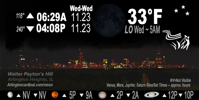
🌑 🌓 🌕 🌗 New Moon, sky cover overnight Tue. to Wed. 0% to 11% to 31%, winds SW, 8 to 6 MPH, G13MPH, 5p to 10p, Low 33, 5a to 7a
NWS CHGO | NWS HRLY | /NWSchicago | 🌡
ARLINGTON HEIGHTS WEATHER
▴ forecast7 (Arl. Hts.) | RADAR | WIDE RADAR
IMPORTANT NOTE ON NWS DATA
======================
Tuesday Night …
No Weather Hazards expected…
This Weather Outlook is for portions of North Central Illinois…Northeast Illinois and Northwest Indiana.
DISCUSSION…
Overnight Tuesday to Wednesday looks similar to the previous night with light winds, but mostly clear skies (less clouds than overnight Monday to Tuesday). Lows should fall into the mid to upper 20s in most areas. Like last night, a pocket or two of shallow ground fog cannot be ruled out at daybreak.
Temperatures forecast to stay above freezing (forecast low 33°F) at O’Hare overnight Tuesday to Wednesday, but Chicago Executive Airport is forecast with a morning low temperature of 29°F.
Hello mobile users! If you encounter mobile “unfriendly” weather page, turn your phone sideways for a better view.
======================
O’HARE FORECAST …
Forecast Beginning Tuesday Night, Nov. 22, 2022
Tuesday Night Clear, with a low around 33. Southwest wind around 5 mph.
Wednesday Sunny, with a high near 60. Southwest wind 5 to 10 mph.
Wednesday Night Partly cloudy, with a low around 39. South wind around 5 mph.
Thanksgiving Day A 20 percent chance of showers after 1pm. Increasing clouds, with a high near 53. South southwest wind 5 to 10 mph.
Thursday Night A slight chance of showers before 7pm, then a chance of rain between 7pm and 1am. Cloudy, with a low around 38. South southwest wind 5 to 10 mph becoming northwest after midnight. Chance of precipitation is 50%.
Friday Partly sunny, with a high near 48.
Friday Night Mostly clear, with a low around 33.
Saturday Mostly sunny, with a high near 49.
Saturday Night A chance of rain after 7pm. Mostly cloudy, with a low around 39.
Sunday A chance of rain. Mostly cloudy, with a high near 45.
Sunday Night A chance of rain. Mostly cloudy, with a low around 33.
Monday Partly sunny, with a high near 42.
Monday Night Mostly cloudy, with a low around 32.
Tuesday Mostly cloudy, with a high near 43.
O’Hare forecast archive and hourly weather observations archive are available HERE on the CARDINAL NEWS Magazine.
Arlingtoncardinal.com/moonphases
Arlingtoncardinal.com/nightsky
NIGHT SKY THIS MONTH …
Check the night sky objects for this month and past months in the playlist from the Space Telescope Science Institute YouTube channel Backyard stargazers get a monthly guide to the northern hemisphere’s skywatching events with “Tonight’s Sky” (Musical track The Far River written by Jonn Serrie, from the album And the Stars Go With You courtesy of New World Music Ltd. Musical track The Far River written by Jonn Serrie, from the album And the Stars Go With You courtesy of New World Music Ltd).
Telephoto lens, ISO 100, f/11, Shutter Speed 1/100 to 1/125 for the Moon.
Get updates from The Cardinal ALL NEWS FEEDS on Facebook. Just ‘LIKE’ the ‘Arlington Cardinal Page (become a fan of our page). The updates cover all posts and sub-category posts from The Cardinal — Arlingtoncardinal.com. You can also limit feeds to specific categories. See all of The Cardinal Facebook fan pages at Arlingtoncardinal.com/about/facebook …
Help fund The Cardinal Arlingtoncardinal.com/sponsor
Telephoto lens, ISO 1600, f/11, Shutter Speed 2.5″ for the skyline. The skyline exposure was toned down, and brightness and contrast was adjusted in Photoshop.
Area Forecast Discussion Two of Two
National Weather Service Chicago/Romeoville, IL
225 AM CST Wed Nov 23 2022
.SHORT TERM… Issued at 225 AM CST Wed Nov 23 2022
Through Thursday…
Majority of guidance has continued to exhibit a cool bias with this week`s warm up and have based today`s high temps largely off local climo of high temps vs progged 925mb temps. This technique has performed well the past couple of days and would support highs generally in the upper 50s to near 60 today. Other than a bit of cirrus streaming into southern CWA late, today will be another sunny day.
Skies will become mostly cloudy tonight, which along with rising dewpoints should result in milder lows compared to recent nights. Thanksgiving will continue to feature above average temperatures, though cloudy skies should keep temps cooler than today. Theta-e advection in advance of an approaching trough should allow for some widely scattered showers to develop, particularly during the afternoon. It doesn`t look like a washout, but don`t be surprised if you need to dodge a few rain drops Thanksgiving Day.
– Izzi/NWS Chicago
Area Forecast Discussion One of Two
National Weather Service Chicago/Romeoville, IL
1121 PM CST Tue Nov 22 2022
.SHORT TERM… Issued at 155 PM CST Tue Nov 22 2022
Through Wednesday night…
There are no forecast concerns in the short term period.
Regional satellite imagery augmented by RAP-analyzed surface pressure fields depict a pleasant late autumn day across the Great Lakes with mostly sunny skies and a weak meridional pressure gradient. Temperatures are in the upper 40s to lower 50s, with even a few 55 to 56 degree readings being observed at press time. Tonight looks similar to last night with light winds but mostly clear skies. Lows should fall into the mid to upper 20s. Like last night, a pocket or two of shallow ground fog cannot be ruled out at daybreak.
Ensemble model guidance is in excellent agreement that an upper- level shortwave currently digging into the Pacific Northwest will continue tracking southeastward tonight and approach the central Rocky Mountains on Wednesday. Increasing low-level warm air advection ahead of the digging trough will boost 925/850mb temperatures some 2 to 3 C over the next 24 hours, setting the stage for an unseasonably warm and pleasant Wednesday. Even with gradually increasing upper-level cloud cover and a modest boost to low-level moisture (surface dew points climbing into the mid to upper 30s), high temperatures tomorrow should have no problem reaching the mid to upper 50s with several 60 degree readings easily attainable. (Record highs of 69 and 65 at Chicago and Rockford, respectively, appear quite safe). Clouds will thicken toward and especially after sunset as warm-air advection further increases.
Borchardt/NWS Chicago
