
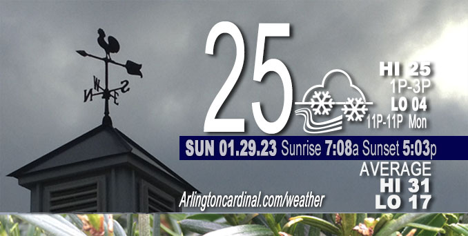
Sunday Hi 25, light snow especially after 5p, cloudy then partly sunny, winds NNW to NW, 13 to 15 to 9 MPH, G22 to 15 MPH, until 5p
NWS CHGO | NWS HRLY | /NWSchicago | 🌡
ARLINGTON HEIGHTS WEATHER
▴ forecast7 (Arl. Hts.) | RADAR | WIDE RADAR
⏪ Hrly Data Table | Hrly Future Graph ⏩
IMPORTANT NOTE ON NWS DATA
⏪ Hrly Data Table | Hrly Future Graph ⏩
======================
Sunday and Sunday Night …
Weather Hazards expected …
Limited Ice Accumulation Risk.
Limited Excessive Cold Risk tonight.
Limited Snow Risk tonight.
DISCUSSION…
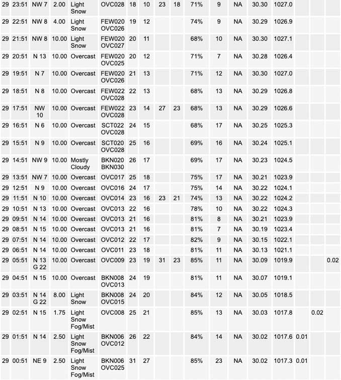
Arlington Heights snowfall measured 3.5 to 4.0 inches at 8:30 a.m. Sunday, January 29, 2023 — following Saturday’s snow system.
Lingering patchy freezing drizzle is possible this morning, mainly north of I-80.
Some light snow could lead to a coating of accumulation late Sunday night, mainly south and east of I-55, including extreme northwest Indiana. There is a chance snow could mix with or change to freezing drizzle late tonight south of the Kankakee River Valley. Snowfall forecast for 6:00 p.m. Sunday to 11:00 a.m. Monday is about 0.1 inch.
The normal daily low temperature is now rising. The normal daily high increases for the first time this year from 31°F to 32°F tomorrow, January 30. We’re gaining about 2 minutes of daylight every day in the progression toward vernal equinox, March 20, 2023.
======================
O’HARE FORECAST …
Forecast Beginning Sunday, Jan. 29, 2023
Sunday: A slight chance of flurries and freezing drizzle before 9am. Mostly cloudy, with a high near 25. North wind 10 to 15 mph, with gusts as high as 20 mph.
Sunday Night: A chance of flurries before midnight, then intermittent snow or flurries after midnight. Cloudy, with a low around 12. North northwest wind around 10 mph. Chance of precipitation is 30%.
Monday: A chance of flurries before noon. Mostly cloudy, with a temperature falling to around 9 by 5pm. Wind chill values as low as -4. Northwest wind around 10 mph, with gusts as high as 20 mph.
Monday Night: Mostly cloudy, with a low around -2. Wind chill values as low as -15. West northwest wind 5 to 10 mph, with gusts as high as 15 mph.
Tuesday: Mostly sunny, with a high near 15. West southwest wind 5 to 10 mph, with gusts as high as 15 mph.
Tuesday Night: Mostly clear, with a low around 5.
Wednesday: Mostly sunny, with a high near 27.
Wednesday Night: Mostly cloudy, with a low around 12.
Thursday: Mostly sunny, with a high near 27.
Thursday Night: Mostly clear, with a low around 11.
Friday: Mostly sunny, with a high near 24.
Friday Night: Mostly cloudy, with a low around 13.
Saturday: Mostly cloudy, with a high near 32.


CHICAGOWEATHERSTATION.COM

ChicagoWeatherStation.com I O’Hare Normal Temps/Precip I O’Hare Record Temps, Precip, Snow
LIVE RADAR | STORM TRACKS | UNISYS US IR SAT | UNISYS Midwest IR SAT | UNISYS More IR SAT
WunderMap® with Temperature/Wind Data || Google: Arlington Heights Area Temps | US TEMPS
Full Screen Motion Weather Radar (Wunderground.com)
Midwest Cloud Cover with Arlington Heights Weather Forecast
ChicagoWeatherStation.com I O’Hare Normal Temps/Precip I O’Hare Record Temps, Precip, Snow
SUNLIGHT DATA FOR SECURITY, TRAFFIC SAFETY, AND SPORTS
SunCalc.net data with solar azimuth and trajectory, times for dawn, sunrise, solar noon, sunset, dusk …
NIGHT SKY THIS MONTH …
Backyard stargazers get a monthly guide to the northern hemisphere’s skywatching events with “Tonight’s Sky.” Check the night sky objects for this month and past months in the playlist from the Space Telescope Science Institute YouTube channel (Musical track The Far River written by Jonn Serrie, from the album And the Stars Go With You courtesy of New World Music Ltd).
Get updates from The Cardinal ALL NEWS FEEDS on Facebook. Just ‘LIKE’ the ‘Arlington Cardinal Page (become a fan of our page). The updates cover all posts and sub-category posts from The Cardinal — Arlingtoncardinal.com. You can also limit feeds to specific categories. See all of The Cardinal Facebook fan pages at Arlingtoncardinal.com/about/facebook …
Help fund The Cardinal Arlingtoncardinal.com/sponsor
Area Forecast Discussion
National Weather Service Chicago/Romeoville, IL
556 AM CST Sun Jan 29 2023
.SHORT TERM… Issued at 303 AM CST Sun Jan 29 2023
Through Monday…
In very short term, extended the winter wx advisory until 6 AM and replaced the winter storm warning with an advisory until 6 AM. Continuing to see patches of flurries/light freezing drizzle across northern IL, which could continue to cause hazardous travel on untreated roads. It is possible this advisory may need to be extended a few more hours, but would prefer to watch observational trends before making that call as shortwave trough and associated ascent, well defined in satellite imagery, quickly shift east of the area by 12z.
Cannot rule out some light lake effect snow showers near the IL shore this morning, with whatever lake effect there is likely to shift into NW IN this afternoon. Forecast soundings all indicate shallow convective layer/low inversion heights. Generally, temps within the convective layer are progged to be no colder than -10C, which suggests that snow quality would be pretty poor, maybe just snow grains. Chances of accumulation appear small and kept just low pops just in case.
Next concern is shortwave trough seen on water vapor imagery over the Four Corners region. This low amplitude wave is forecast translate eastward and across the mid-Mississippi Valley region tonight into early Monday morning. Surprisingly coherent signal in the guidance showing some modest ascent and saturation up to around 10kft, mainly southeast 1/2 to 1/3 of CWA. Despite progged deep isothermal layer near the lower end the prime DGZ, rather weak ascent and lack of supersaturation, suggest dendrites may not be the primary snowflake type. Still, deep isothermal layer around these temps often makes it easier to snow, so even though QPF signal in guidance is meager, think some light snow or flurries are likely, especially southeast of I-55. At most, probably only looking at a coating of snow, but with sfc temps in the teens, that could pose a travel hazard on untreated roads.
One other item of note, is that south of the Kankakee River Valley, that isothermal layer is progged to be a bit warmer, closer to -8 to -10C, which raise concerns about the presence of ice nuclei in the clouds. If clouds lose ice, then freezing drizzle or very light freezing rain could become a problem. For now, just introduced a chance of freezing drizzle in the grids, but day shift will get another look and may need to hit the icing potential a bit harder.
– Izzi/NWS Chicago
