
Wednesday Hi 82, mostly sunny, winds SW, 12 to 22 to 15 MPH, G21 to 33 to 20 MPH, 5a to 11p
NWS CHGO | NWS HRLY | /NWSchicago | 🌡
ARLINGTON HEIGHTS WEATHER
▴ forecast7 (Arl. Hts.) | RADAR | WIDE RADAR
⏪ Hrly Data Table | Hrly Future Graph ⏩
IMPORTANT NOTE ON NWS DATA
⏪ Hrly Data Table | Hrly Future Graph ⏩
Hello mobile users! If you encounter a mobile “unfriendly” weather page, turn your phone sideways for a better view.
======================
Wednesday and Wednesday Evening …
Weather Hazards expected …
Significant Fire Weather Risk.
Red Flag Warning activated at 2:40 a.m. for Wednesday 11 AM to 7 PM.
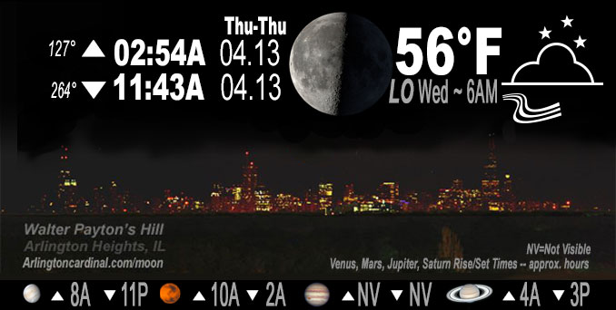
Wednesday high temperature 82 well above normal 58; and record high could be broken Thursday if O’Hare Temperature exceeds 82. At NWS Chicago O’Hare the record high for April 12 is 86. The record high for April 13 is 82.
DISCUSSION…
Very dry, windy, and unseasonably warm today, which will create conditions very favorable for the ignition and rapid spread of wildfires.
Red Flag Warning URGENT – FIRE WEATHER MESSAGE
National Weather Service Chicago IL
240 AM CDT Wed Apr 12 2023
Winnebago-Boone-McHenry-Lake IL-Ogle-Lee-De Kalb-Kane-DuPage-Cook- La Salle-Kendall-Grundy-Will-Kankakee-Livingston-Iroquois-Ford- Lake IN-Porter-Newton-Jasper-Benton- 240 AM CDT Wed Apr 12 2023 /340 AM EDT Wed Apr 12 2023/
…RED FLAG WARNING IN EFFECT FROM 11 AM CDT THIS MORNING TO 7 PM CDT THIS EVENING…
The National Weather Service in Chicago has issued a Red Flag Warning, which is in effect from 11 AM CDT this morning to 7 PM CDT this evening. The Fire Weather Watch is no longer in effect.
* Affected Area…Lake (IN), Porter, Winnebago, Boone, McHenry, Lake (IL), Ogle, Lee, Newton, De Kalb, Jasper, Kane, DuPage, Cook, La Salle, Benton, Kendall, Grundy, Will, Kankakee, Livingston, Iroquois, and Ford Counties.
* Timing…11 AM to 7 PM CDT Wednesday.
* Winds…Southwest 15 to 20 mph with gusts up to 35 mph.
* Relative Humidity…As low as 20 percent.
* Impacts…Dry fuels, low relative humidity, and strong winds will create conditions favorable for the rapid spread of wildfires.
PRECAUTIONARY/PREPAREDNESS ACTIONS…
A Red Flag Warning means that critical fire weather conditions are either occurring now, or will shortly. A combination of strong winds, low relative humidity, and warm temperatures can contribute to extreme fire behavior.
======================
O’HARE FORECAST …
Forecast Beginning Wednesday, Apr. 12, 2023
Wednesday: Sunny, with a high near 82. Breezy, with a southwest wind 15 to 20 mph, with gusts as high as 35 mph.
Wednesday Night: Clear, with a low around 56. Southwest wind 10 to 15 mph, with gusts as high as 25 mph.
Thursday: Sunny, with a high near 82. Southwest wind 10 to 15 mph, with gusts as high as 25 mph.
Thursday Night: Partly cloudy, with a low around 55. South southwest wind 5 to 15 mph, with gusts as high as 20 mph.
Friday: Mostly sunny, with a high near 76. South wind 5 to 15 mph, with gusts as high as 20 mph.
Friday Night: Mostly cloudy, with a low around 59.
Saturday: A slight chance of showers, then showers and thunderstorms likely after 1pm. Partly sunny, with a high near 75. Chance of precipitation is 60%.
Saturday Night: Showers and thunderstorms likely before 1am, then a chance of showers. Mostly cloudy, with a low around 44.
Sunday: A chance of showers. Mostly cloudy, with a high near 52. Breezy.
Sunday Night: Mostly cloudy, with a low around 36. Breezy.
Monday: A chance of showers. Mostly cloudy, with a high near 47. Breezy.
Monday Night: Mostly cloudy, with a low around 37.
Tuesday: Partly sunny, with a high near 52.


CHICAGOWEATHERSTATION.COM

ChicagoWeatherStation.com I O’Hare Normal Temps/Precip I O’Hare Record Temps, Precip, Snow
WunderMap® with Temperature/Wind Data || Google: Arlington Heights Area Temps | US TEMPS
Midwest Cloud Cover with Arlington Heights Weather Forecast
ChicagoWeatherStation.com I O’Hare Normal Temps/Precip I O’Hare Record Temps, Precip, Snow
SUNLIGHT DATA FOR SECURITY, TRAFFIC SAFETY, AND SPORTS
SunCalc.net data with solar azimuth and trajectory, times for dawn, sunrise, solar noon, sunset, dusk …
NIGHT SKY THIS MONTH …
Backyard stargazers get a monthly guide to the northern hemisphere’s skywatching events with “Tonight’s Sky.” Check the night sky objects for this month and past months in the playlist from the Space Telescope Science Institute YouTube channel (Musical track The Far River written by Jonn Serrie, from the album And the Stars Go With You courtesy of New World Music Ltd).
Get updates from The Cardinal ALL NEWS FEEDS on Facebook. Just ‘LIKE’ the ‘Arlington Cardinal Page (become a fan of our page). The updates cover all posts and sub-category posts from The Cardinal — Arlingtoncardinal.com. You can also limit feeds to specific categories. See all of The Cardinal Facebook fan pages at Arlingtoncardinal.com/about/facebook …
Help fund The Cardinal Arlingtoncardinal.com/sponsor
/////////////>
Area Forecast Discussion
National Weather Service Chicago/Romeoville, IL
626 AM CDT Wed Apr 12 2023
.SHORT TERM… Issued at 211 AM CDT Wed Apr 12 2023
Through Thursday…
Not much to discuss in the short term. Most guidance continues to exhibit a cool and moist bias in the boundary layer with RAP and HRRR performing quite well. See no reason that this trend won`t continue today with widespread 80F+ high temps likely. The warmer and dry boundary layer will mix deeply and allow for some occasional gusts to around 30kt to be transported to the sfc in gusts late this morning into this afternoon. Thursday looks to be a carbon copy of today, but with slightly less wind. In fact, high temps tomorrow could threaten daily record highs (Chicago: 82/1941 and Rockford 83/2006)!
– Izzi/NWS Chicago
