
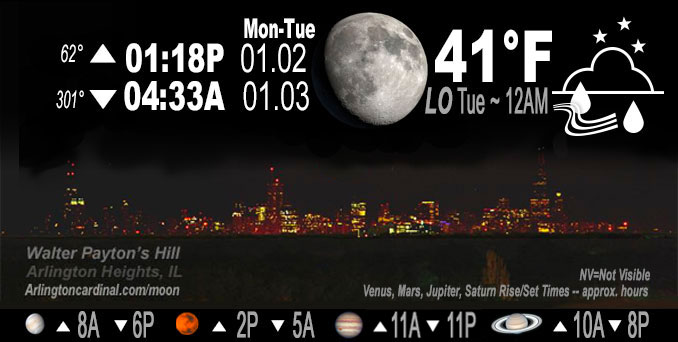
🌔 🌕 🌗 🌑 Waxing Gibbous Moon, sky cover overnight Mon. to Tue. 100%, rain starts 1a, winds NE to ENE, 9 to 11 to 8 MPH, G14 to 17 to 13 MPH, Low 41, 12a to 1a
NWS CHGO | NWS HRLY | /NWSchicago | 🌡
ARLINGTON HEIGHTS WEATHER
▴ forecast7 (Arl. Hts.) | RADAR | WIDE RADAR
IMPORTANT NOTE ON NWS DATA
======================
NIGHT FORECASTS …
NOTE 1: Forecast and information text below may refer to a previous night on Arlingtoncardinal.com, and might not be updated until late afternoon, evening, or overnight. However, Night Sky archives on CARDINAL NEWS Magazine include text forecasts that correspond to the lunar phase graphic above.
NOTE 2: Keep in mind lunar rise and set times don’t always correspond with night weather and early morning lows because on some days during the month the moon is visible in the sky predominantly during the daytime hours.
Overnight Monday/Tuesday …
Weather Hazards expected …
Significant Dense Fog Risk.
Limited Thunderstorm Risk.
DISCUSSION…
Areas of dense fog will continue near Lake Michigan, and will likely develop inland across much of northeastern Illinois and northwestern Indiana Monday evening.
Rainfall overnight may be heavy at times and this may lead to significant ponding in low lying areas. In addition, embedded thunderstorms are possible late tonight and overnight. A couple of these thunderstorm may be strong south of the Kankakee River Valley. Arlington Heights has only a slight chance of a little lightning and thunder from about 12:00 a.m. 8:00 a.m. Tuesday.
The high temperature forecast for Tuesday Arlington Heights has trended significantly downward from a high of 59°F to high 49°F because a warm front is not expected to reach as far north as was initially expected. South suburbs, such as Orland Park, may see temperatures near 60°F, but the forecast now indicates that northern Chicagoland will not reach the 50s. Antioch, Illinois is only expected reach a high of 44°F from 4:00 p.m. to 7:00 p.m. Tuesday.
At 11:30 p.m. Tuesday high temperatures forecast: Orland Park 58°F, Kankakee 60°F, DeKalb 50°F, Arlington Heights 49°F, and Waukegan 44°F.
Hello mobile users! If you encounter mobile “unfriendly” weather page, turn your phone sideways for a better view.
======================
O’HARE FORECAST …
Forecast Beginning Monday Night, Jan. 02, 2023 …
Monday Night: A slight chance of rain before midnight, then a chance of rain and thunderstorms between midnight and 1am, then rain and possibly a thunderstorm after 1am. Areas of fog. Temperature rising to around 43 by 4am. East northeast wind around 10 mph, with gusts as high as 15 mph. Chance of precipitation is 100%. New rainfall amounts between a half and three quarters of an inch possible.
Tuesday: Rain and possibly a thunderstorm before 9am, then a chance of rain. Areas of fog before 3pm. High near 49. Northeast wind 5 to 10 mph becoming southeast in the afternoon. Winds could gust as high as 15 mph. Chance of precipitation is 80%. New precipitation amounts of less than a tenth of an inch, except higher amounts possible in thunderstorms.
Tuesday Night: A 20 percent chance of rain before 9pm. Mostly cloudy, with a low around 38. East wind around 5 mph becoming west after midnight. Winds could gust as high as 10 mph.
Wednesday: A slight chance of rain showers before 3pm, then a slight chance of rain and snow showers. Mostly cloudy, with a high near 40. Southwest wind 5 to 10 mph, with gusts as high as 15 mph. Chance of precipitation is 20%.
Wednesday Night: Scattered snow showers. Mostly cloudy, with a low around 31. Southwest wind 5 to 10 mph, with gusts as high as 15 mph. Chance of precipitation is 30%.
Thursday: Scattered snow showers. Cloudy, with a high near 35. Chance of precipitation is 50%.
Thursday Night: Mostly cloudy, with a low around 25.
Friday: Partly sunny, with a high near 34.
Friday Night: Mostly cloudy, with a low around 26.
Saturday: Partly sunny, with a high near 34.
Saturday Night: Mostly cloudy, with a low around 28.
Sunday: Partly sunny, with a high near 35.
Sunday Night: Mostly cloudy, with a low around 27.
Monday: Mostly sunny, with a high near 37.
O’Hare forecast archive and hourly weather observations archive are available HERE on the CARDINAL NEWS Magazine.
Arlingtoncardinal.com/moonphases
Arlingtoncardinal.com/nightsky
NIGHT SKY THIS MONTH …
Check the night sky objects for this month and past months in the playlist from the Space Telescope Science Institute YouTube channel Backyard stargazers get a monthly guide to the northern hemisphere’s skywatching events with “Tonight’s Sky” (Musical track The Far River written by Jonn Serrie, from the album And the Stars Go With You courtesy of New World Music Ltd. Musical track The Far River written by Jonn Serrie, from the album And the Stars Go With You courtesy of New World Music Ltd).
Telephoto lens, ISO 100, f/11, Shutter Speed 1/100 to 1/125 for the Moon.
Get updates from The Cardinal ALL NEWS FEEDS on Facebook. Just ‘LIKE’ the ‘Arlington Cardinal Page (become a fan of our page). The updates cover all posts and sub-category posts from The Cardinal — Arlingtoncardinal.com. You can also limit feeds to specific categories. See all of The Cardinal Facebook fan pages at Arlingtoncardinal.com/about/facebook …
Help fund The Cardinal Arlingtoncardinal.com/sponsor
Telephoto lens, ISO 1600, f/11, Shutter Speed 2.5″ for the skyline. The skyline exposure was toned down, and brightness and contrast was adjusted in Photoshop.
Area Forecast Discussion
National Weather Service Chicago/Romeoville, IL
1102 PM CST Mon Jan 2 2023
.SHORT TERM… Issued at 321 PM CST Mon Jan 2 2023
Through Tuesday night…
Key forecast concerns… *Fog expected to persist through this evening, could be dense in spots
*Rain moves in late this evening and lingers into the day on Tuesday, chance for an embedded thunderstorm or two tonight and Tuesday afternoon
*Possibly near record high temperatures Tuesday afternoon
A developing warm front continues to reside across the Ohio River Valley with its parent surface low still over the southern Plains. Ahead of the warm front the slowly moistening air mass has allowed for some of the earlier fog to persist into this afternoon. While most areas are reporting only minor visibility reductions there are areas of denser fog being reported across the southern Chicago metro, portions of northwestern Indiana near Lake Michigan and portions of central Illinois. The denser fog is expected to expand inland from the lake and northward from central Illinois this evening as we lose day time heating which would lead to hazardous travel for the evening commute especially for areas along and east of I-55. While this trend is supported by forecast guidance there is some uncertainty as to how dense the fog would be and the extent of its coverage. For now I have maintained a patchy fog mention across the entire CWA through tonight with an area of fog mention for areas close to Lake Michigan and areas along and east of I-55 where the potential for denser fog looks to be the greatest. There is also a Dense Fog Advisory in effect through 9 PM CST this evening for southern Cook, Lake, IN, and Porter counties where conditions have continued to be poor especially along the I-80/I-94 corridor.
As the aforementioned surface low lifts northward into the central plains and the warm front lifts northward into our area, rain is expected to develop along the front and expand in coverage during the late evening hours. Guidance continues to show that precipitable water values around 1.0 to 1.5 inches would be in place as the rain begins which would allow for soaking rainfall to set up across the area and continue through the night. Additionally, forecast soundings are also continuing to show some marginal instability developing along the front this evening which may allow for isolated embedded thunderstorms with the rain tonight. While there may be some heavier downpours at times, rainfall amounts are forecast to be in the 0.5 to one inch range through Tuesday morning.
While rain chances do look to diminish Tuesday morning as the dry slot moves into the area, additional showers are expected to develo Palong a cold front Tuesday afternoon. Forecast soundings are indicating that much better instability would set up Tuesday afternoon with decent unidirectional shear profiles in place as an upper-level jet moves overhead. Whether or not this instability can be realized will depend on how much return surface moisture will get into the area and how warm temperatures will become. Should things be able to warm into the upper 50s to near 60s soundings show that the instability would able to become surface based which could allow for a few of these storms to become strong to severe Tuesday afternoon into the early evening hours. Obviously there is still some uncertainty as to how well temperatures will warm given the lingering cloud cover and northward extent of the warm front this evening, but if the severe potential can be realized the primary threat looks to be gusty winds and the greatest threat looks to be for areas east of I-55. At this time we are not outlooked for severe weather, but if trends maintain themselves that could change with future forecasts.
Lastly, temperatures on Tuesday will also be well above normal during the afternoon as the area resides near if not in the warm sector. Depending on how far north the warm front can make it tonight there is the potential that some areas could see temperatures approaching record high values near 60 degrees. Guidance has trended a bit cooler with highs due to the slow progress of the warm front today, but it still looks like most areas should see temperatures in the low to mid 50s with areas along and east of I-55 seeing values in the upper 50s to near 60.
Yack/NWS Chicago
