
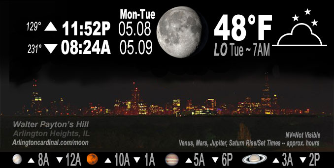
🌖 🌗 🌑 🌓 Waning Gibbous Moon, sky cover overnight Mon. to Tue. 82% to 76%, winds NE 12 to 13 to 7 MPH, G15 to 20 to 15, Low 48, 4a to 6a
NWS CHGO | NWS HRLY | /NWSchicago | 🌡
ARLINGTON HEIGHTS WEATHER
▴ forecast7 (Arl. Hts.) | RADAR | WIDE RADAR
IMPORTANT NOTE ON NWS DATA
Hello mobile users! If you encounter a mobile “unfriendly” weather page, turn your phone sideways for a better view.
======================
NIGHT FORECASTS …
NOTE: Keep in mind lunar rise and set times don’t always correspond with night weather and early morning lows because on some days during the month the moon is visible in the sky predominantly during the daytime hours.
Overnight Monday to Tuesday …
Weather Hazards expected …
Fog risk.
Thunderstorm risk ending late afternoon/early evening south of I-80 and I-55.
DISCUSSION…
Some areas of dense fog into the grids across northern and western portions of the CWA.
======================
O’HARE FORECAST …
Forecast Beginning Monday Night, May 08, 2023 …
Monday Night: Patchy fog after 4am. Otherwise, mostly cloudy, with a low around 48. North wind around 5 mph.
Tuesday: Areas of fog before 9am. Otherwise, mostly sunny, with a high near 70. North northeast wind 5 to 10 mph, with gusts as high as 15 mph.
Tuesday Night: Mostly clear, with a low around 48. East wind around 5 mph becoming calm in the evening.
Wednesday: Sunny, with a high near 78. Light and variable wind becoming southeast 5 to 10 mph in the morning. Winds could gust as high as 15 mph.
Wednesday Night: Partly cloudy, with a low around 54. South southeast wind 5 to 10 mph.
Thursday: Mostly sunny, with a high near 80.
Thursday Night: A slight chance of showers before 1am, then a chance of showers and thunderstorms between 1am and 4am, then a chance of showers after 4am. Mostly cloudy, with a low around 61. Chance of precipitation is 30%.
Friday: Showers likely. Mostly cloudy, with a high near 77.
Friday Night: Showers likely. Mostly cloudy, with a low around 61.
Saturday: A chance of showers. Mostly cloudy, with a high near 75.
Saturday Night: A chance of showers. Mostly cloudy, with a low around 56.
Sunday: A chance of showers. Mostly cloudy, with a high near 66.
Sunday Night: Mostly cloudy, with a low around 48.
Monday: Mostly sunny, with a high near 71.
O’Hare forecast archive and hourly weather observations archive are available HERE on the CARDINAL NEWS Magazine.
Arlingtoncardinal.com/moonphases
Arlingtoncardinal.com/nightsky
NIGHT SKY THIS MONTH …
Check the night sky objects for this month and past months in the playlist from the Space Telescope Science Institute YouTube channel Backyard stargazers get a monthly guide to the northern hemisphere’s skywatching events with “Tonight’s Sky” (Musical track The Far River written by Jonn Serrie, from the album And the Stars Go With You courtesy of New World Music Ltd. Musical track The Far River written by Jonn Serrie, from the album And the Stars Go With You courtesy of New World Music Ltd).
Telephoto lens, ISO 100, f/11, Shutter Speed 1/100 to 1/125 for the Moon.
Get updates from The Cardinal ALL NEWS FEEDS on Facebook. Just ‘LIKE’ the ‘Arlington Cardinal Page (become a fan of our page). The updates cover all posts and sub-category posts from The Cardinal — Arlingtoncardinal.com. You can also limit feeds to specific categories. See all of The Cardinal Facebook fan pages at Arlingtoncardinal.com/about/facebook …
Help fund The Cardinal Arlingtoncardinal.com/sponsor
Telephoto lens, ISO 1600, f/11, Shutter Speed 2.5″ for the skyline. The skyline exposure was toned down, and brightness and contrast was adjusted in Photoshop.
/////////////>
Area Forecast Discussion
National Weather Service Chicago/Romeoville, IL
923 PM CDT Mon May 8 2023
.UPDATE… Issued at 923 PM CDT Mon May 8 2023
Forecast generally on track. Only change planned is to introduce some areas of dense fog into the grids across northern and western portions of the CWA. While fog forecasting is notoriously challenging, there is a strong signal in some of the reliable guidance pointing toward widespread dense fog developing. Dewpoint depressions are already quite low and with a brief period of clearing late this evening, should see those T/Td spreads drop to near zero. In addition, BL is moist following recent rainfall and winds (already light) should become nearly calm as sfc high over WI drops south. Have seen too many of these seemingly good set ups not materialize to issue a proactive dense fog advisory, but will be updating to hit fog harder in grids and text products.
Updates should be out shortly.
– Izzi
&&
.SHORT TERM… Issued at 308 PM CDT Mon May 8 2023
Through Tuesday night…
As of early this afternoon most areas are dry other than lingering rain and drizzle along and north of Interstate-90 and lake adjacent areas. The center of the surface low has shifted into the area now centered over the Livingston, Ford, Iroquois county area. Directly beneath this feature a few spotty showers have been festering along a surface convergence axis extending east into Indiana, though have so far struggled to become much more than that. Given some breaks in the clouds this area and temperatures warming into the lower 70 there should be sufficient instability for a few isolated thunderstorms to develop before the low exits the area by late afternoon/early evening south of I-80 and I-55. The window to see a stronger to near severe storm appears to be shrinking, though the potential is not zero given near 40kt of deep layer shear to work with if a more robust storm can get established along the boundary. Thus will continue to message a low chance for large hail and damaging winds, though again confidence in seeing severe weather is low and would be confined to locales south of a Pontiac to Kankakee to Valparaiso line.
Light rain and drizzle may persist ant times into early evening for areas north of I-80 though it will decrease in intensity with each passing hour. There remains a signal for at least patchy fog this evening and overnight though think that model guidance may be overdone due to influence of very low stratus, which appears to be more likely. The continued cloud cover influence will limit our cooling tonight to the mid 40s to lower 50s for early Tuesday morning lows.
Tuesday looks quiet as surface high pressure centers over Wisconsin and Lake Michigan. This will allow for continued north the northeast winds which will limit warming in lake adjacent areas. It also appears a reinforcing lake breeze will cool off temperatures during the afternoon from northeast to southwest across the Chicago metro area.
Petr/NWS Chicago
