
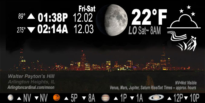
🌔 🌕 🌗 🌑 Waxing Gibbous Moon, sky cover overnight Fri. to Sat. 90% to 94% to 10%, winds SSW, 23 to 28 to 21 MPH, G41 to 38 to 37 MPH, Low 22, 8a to 9a
NWS CHGO | NWS HRLY | /NWSchicago | 🌡
ARLINGTON HEIGHTS WEATHER
▴ forecast7 (Arl. Hts.) | RADAR | WIDE RADAR
IMPORTANT NOTE ON NWS DATA
======================
Overnight Friday/Saturday …
Weather Hazards expected…
Elevated Non Thunderstorm Wind Risk.
DISCUSSION…
(9:41 PM) A relative lull wind-wise occurred with recent gusts across the area remaining restricted below 40 mph, and even below 30 mph in some parts of our northern CWA. Not expecting this to change prior to the passage of the cold front.
Southerly winds will gust to 40 to 45 mph on this afternoon and evening ahead of a cold front. Westerly winds will then gust to 45 mph, possibly higher, behind the cold front late tonight night into early Saturday morning.
Hello mobile users! If you encounter mobile “unfriendly” weather page, turn your phone sideways for a better view.
======================
O’HARE FORECAST …
Forecast Beginning Friday Night, Dec. 2, 2022
Friday Night: A 30 percent chance of rain, mainly before midnight. Cloudy, then gradually becoming partly cloudy, with a low around 22. Windy, with a south southwest wind 25 to 30 mph becoming west northwest after midnight. Winds could gust as high as 45 mph.
Saturday: Sunny, with a high near 30. Blustery, with a west northwest wind 15 to 20 mph decreasing to 10 to 15 mph in the afternoon. Winds could gust as high as 40 mph.
Saturday Night: Mostly clear, with a low around 21. West wind 5 to 10 mph.
Sunday: Sunny, with a high near 40. West southwest wind 10 to 15 mph, with gusts as high as 30 mph.
Sunday Night: Partly cloudy, with a low around 25.
Monday: A 30 percent chance of rain after noon. Mostly cloudy, with a high near 42.
Monday Night: Mostly cloudy, with a low around 31.
Tuesday: Partly sunny, with a high near 40.
Tuesday Night: Mostly cloudy, with a low around 23.
Wednesday: Partly sunny, with a high near 34.
Wednesday Night: Partly cloudy, with a low around 22.
Thursday: Partly sunny, with a high near 35.
O’Hare forecast archive and hourly weather observations archive are available HERE on the CARDINAL NEWS Magazine.
Arlingtoncardinal.com/moonphases
Arlingtoncardinal.com/nightsky
NIGHT SKY THIS MONTH …
Check the night sky objects for this month and past months in the playlist from the Space Telescope Science Institute YouTube channel Backyard stargazers get a monthly guide to the northern hemisphere’s skywatching events with “Tonight’s Sky” (Musical track The Far River written by Jonn Serrie, from the album And the Stars Go With You courtesy of New World Music Ltd. Musical track The Far River written by Jonn Serrie, from the album And the Stars Go With You courtesy of New World Music Ltd).
Telephoto lens, ISO 100, f/11, Shutter Speed 1/100 to 1/125 for the Moon.
Get updates from The Cardinal ALL NEWS FEEDS on Facebook. Just ‘LIKE’ the ‘Arlington Cardinal Page (become a fan of our page). The updates cover all posts and sub-category posts from The Cardinal — Arlingtoncardinal.com. You can also limit feeds to specific categories. See all of The Cardinal Facebook fan pages at Arlingtoncardinal.com/about/facebook …
Help fund The Cardinal Arlingtoncardinal.com/sponsor
Telephoto lens, ISO 1600, f/11, Shutter Speed 2.5″ for the skyline. The skyline exposure was toned down, and brightness and contrast was adjusted in Photoshop.
Area Forecast Discussion
National Weather Service Chicago/Romeoville, IL
941 PM CST Fri Dec 2 2022
.UPDATE… Issued at 941 PM CST Fri Dec 2 2022
Made a couple of touch-ups to the forecast this evening, mainly to account for observational trends. 0330Z surface and radar observations depict our well-advertised strong cold front currently hauling its way into northwest Illinois with FROPA imminent for our CWA within the next couple of hours. Ahead of the front, we`ve found ourselves in a relative lull wind-wise with recent gusts across the area remaining restricted below 40 mph, and even below 30 mph in some parts of our northern CWA. Not expecting this to change prior to the passage of the cold front, so have bumped our winds and gusts down for the next 1-3 hours. However, still anticipating 40-45 mph gusts to become commonplace for a few hours here overnight in the robust cold air advection regime on the backside of the cold front as we begin to more regularly tap into stronger flow in the 900-925 mb layer. The stronger gusts should still taper off by the time daybreak comes around, though it`ll still feel quite blustery out there through tomorrow afternoon as 25-35 mph gusts continue amidst freezing temperatures that won`t rise much during the daytime despite abundant sunshine courtesy of the ongoing cold air advection.
The other changes of note were made to our PoP and weather grids. First, while some light precipitation echoes have blossomed over part of the CWA this evening, have trended our mentionable PoPs down and later a little bit to account for the relatively shallow low- level moisture exhibited in the 00Z DVN and ILX RAOBs. The ongoing precipitation appears unlikely to accumulate for at least the next hour or so, but as ascent continues to increase and saturate the low-levels ahead of the cold front this evening, still foresee an uptick in this activity that could lead to light precipitation accumulations (under 0.05″) across the eastern half or so of our CWA prior to the cold front completing its transit of our forecast area.
Additionally, confidence has increased that we`ll see a period of at least flurries during the overnight hours with radar trends showing that a band of frontogentically-forced snow working its way across Iowa isn`t letting up much. Most 00Z hi-res guidance has caught onto this band a little better than previous model runs, and forecast soundings seem to indicate that flurries, if not true snow showers, are looking like an increasingly likely possibility for at least part of our CWA for a brief window of time overnight. With this snow being blown around by the strong winds in the wake of the cold front, have been seeing some non-insignificant visibility reductions across western Iowa, and there is some concern that some of those lower visibilities could be witnessed here for a brief period of time overnight if the intensity of the snow band doesn`t diminish much. The presence of drier mid-level air over our forecast area makes this a low confidence/low probability scenario at this time, so for now, have added a mention of overnight flurries to the going forecast, but will continue to monitor upstream observational trends to see if additional changes need to be made.
Ogorek/NWS Chicago
.SHORT TERM… Issued at 209 PM CST Fri Dec 2 2022
Through Saturday night…
Main forecast concerns for the short term period: *Gusty winds continue through tonight before gradually easing Saturday afternoon
*Sharp drop in temperatures tonight behind a strong cold front
*Chance for some light rain showers and/or drizzle this evening into the early overnight hours
A surface low continues to develop as it moves across the upper Midwest into the northern Great Lakes with a cold front currently being analyzed from eastern South Dakota extending southwestward across central Nebraska into northern Colorado. At the same time an upper-level trough continues to advance across the northern Rockies into the northern Plains with a strong 100+ kt jet streak being analyzed across the central Plains. Ahead of the cold front strong southerly winds continue to be observed across northeastern Illinois and northwest Indiana which is allowing warmer and more moist air to be advected into the area. As the cold front and upper-level trough begin to near the area this evening rain showers are expected to develop along and just ahead of the front and move across our area this evening into the early overnight hours. Forecast soundings continue to show that a large area of dry air will continue to reside in the mid-levels this evening with the better moisture for precipitation expected to be in the lowest 7000 ft or so. This should keep the nature of the rain to light showers and/or drizzle. Rain chance will diminish from west to east behind the front with most areas expected to be rain-free by daybreak Saturday morning.
The biggest concern with this system continues to be the gusty winds currently being observed ahead of the front and the second wave of winds behind the front. The southerly winds have continued to increase this afternoon with gusts around 30 mph currently being observed, winds are expected to continue to increase as a strong 50 to 60 kt low-level jet develops this evening. Forecast soundings continue to show that the atmosphere would be mixed enough to tap into this jet this evening which will allow gusts to reach 30 to 35 mph areawide with higher gusts up to 45 mph likely for areas south and east of I-55. As the cold front pushes through the area the winds will become westerly and the strong cold advection will allow the atmosphere to tap into 40 to 45 mph gusts that are expected to linger into Saturday morning. Given this potential a Wind Advisory remains in effect for areas southeast of I-55 until Saturday morning with another Wind Advisory going into effect at 6 PM CST this evening for the rest of northern Illinois also until Saturday morning. Those in the advisory areas should secure any loose outdoor objects and decorations and be careful if driving larger profile vehicles. Winds will gradually ease through the day on Saturday as a surface high begins to move into the area.
In addition to the winds and showers, the cold front will also plummet temperatures tonight into Saturday morning. Current temperatures are sitting in the mid to upper 40s with some spots near 50 degrees with some additional warming a few degrees expected prior to the arrival of the front. However, once the cold front arrives temperatures will drop into the low to mid 20s by daybreak Saturday morning with the gusty winds creating wind chills around 5 to 10 degrees. The aforementioned cold advection will keep temperatures chilly for our Saturday with highs expected to top out in the upper 20s and lower 30s. On the bright side, as the surface high moves into the area skies will be mostly sunny by the afternoon and are expected to remain as such through Saturday night. The clear skies Saturday night will once again allow for a cold night with low temperatures expected to be in the teens by Sunday morning. So if planning to be outdoors Saturday be sure to bundle up.
Yack/NWS Chicago
