
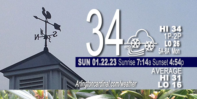
Sunday Hi 34, snow tapers off by 3p, cloudy, winds NW to N to NW, calm to 10 to 8 MPH, G14 MPH and up through Monday
NWS CHGO | NWS HRLY | /NWSchicago | 🌡
ARLINGTON HEIGHTS WEATHER
▴ forecast7 (Arl. Hts.) | RADAR | WIDE RADAR
⏪ Hrly Data Table | Hrly Future Graph ⏩
IMPORTANT NOTE ON NWS DATA
⏪ Hrly Data Table | Hrly Future Graph ⏩
======================
Sunday and Sunday Night …
Weather Hazards expected …
Limited Snow Risk in the morning and then snow flurries for slippery travel.
DISCUSSION…
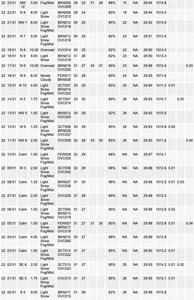
Areas of light snow was falling on a good portion of Chicagoland early Sunday morning. Embedded in the lighter snow was a swath of moderate snow showers at 230 AM lined up along the I-88 and I-90 corridors. Only 1.5 inch of snow was reported at O’Hare on Sunday from about 2:00 a.m. to 4:00 p.m. Most snow in Arlington Heights melted by 4:00 p.m. Snow on pavement was considerably less — barely 0.5 inch in many areas near Arlington Heights, and was zero closer to the warmth of buildings. Only 1.0 inch was reported in much of Arlington Heights, Palatine, and Mount Prospect. Only 0.8 inch reported in Mundelein.
Less than one week left of the normal daily low temperature bottomed out at 16°F. Daily high increases from 31°F to 32°F in nine days. Two minutes of daylight gained Friday, Saturday and Sunday. On Sunday both minutes were gained on the sunset side.
======================
O’HARE FORECAST …
Forecast Beginning Sunday, Jan. 22, 2023
Sunday: Snow likely, mainly before 3pm, then a chance of flurries after 5pm. Patchy fog before noon. Otherwise, cloudy, with a high near 35. Calm wind becoming north around 5 mph in the afternoon. Winds could gust as high as 10 mph. Chance of precipitation is 70%. New snow accumulation of less than one inch possible.
Sunday Night: A chance of flurries before 10pm. Cloudy, with a low around 26. Northwest wind around 10 mph, with gusts as high as 15 mph.
Monday: Cloudy, with a high near 34. West southwest wind 10 to 15 mph, with gusts as high as 30 mph.
Monday Night: Mostly cloudy, with a low around 30. West wind 10 to 15 mph, with gusts as high as 30 mph.
Tuesday: Mostly cloudy, with a high near 34. West wind 5 to 10 mph.
Tuesday Night: A 20 percent chance of snow after midnight. Cloudy, with a low around 29. South southwest wind 5 to 10 mph becoming east northeast after midnight.
Wednesday: Snow likely. Cloudy, with a high near 33. Chance of precipitation is 70%.
Wednesday Night: A 20 percent chance of snow showers. Cloudy, with a low around 26.
Thursday: Cloudy, with a high near 32.
Thursday Night: Mostly cloudy, with a low around 19.
Friday: A chance of snow showers after noon. Cloudy, with a high near 35. Breezy.
Friday Night: Cloudy, with a low around 20.
Saturday: Cloudy, with a high near 29.
Saturday Night: Cloudy, with a low around 20.
Sunday: A chance of snow. Cloudy, with a high near 29.


CHICAGOWEATHERSTATION.COM

ChicagoWeatherStation.com I O’Hare Normal Temps/Precip I O’Hare Record Temps, Precip, Snow
LIVE RADAR | STORM TRACKS | UNISYS US IR SAT | UNISYS Midwest IR SAT | UNISYS More IR SAT
WunderMap® with Temperature/Wind Data || Google: Arlington Heights Area Temps | US TEMPS
Full Screen Motion Weather Radar (Wunderground.com)
Midwest Cloud Cover with Arlington Heights Weather Forecast
ChicagoWeatherStation.com I O’Hare Normal Temps/Precip I O’Hare Record Temps, Precip, Snow
SUNLIGHT DATA FOR SECURITY, TRAFFIC SAFETY, AND SPORTS
SunCalc.net data with solar azimuth and trajectory, times for dawn, sunrise, solar noon, sunset, dusk …
NIGHT SKY THIS MONTH …
Backyard stargazers get a monthly guide to the northern hemisphere’s skywatching events with “Tonight’s Sky.” Check the night sky objects for this month and past months in the playlist from the Space Telescope Science Institute YouTube channel (Musical track The Far River written by Jonn Serrie, from the album And the Stars Go With You courtesy of New World Music Ltd).
Get updates from The Cardinal ALL NEWS FEEDS on Facebook. Just ‘LIKE’ the ‘Arlington Cardinal Page (become a fan of our page). The updates cover all posts and sub-category posts from The Cardinal — Arlingtoncardinal.com. You can also limit feeds to specific categories. See all of The Cardinal Facebook fan pages at Arlingtoncardinal.com/about/facebook …
Help fund The Cardinal Arlingtoncardinal.com/sponsor
Area Forecast Discussion
National Weather Service Chicago/Romeoville, IL
556 AM CST Sun Jan 22 2023
.SHORT TERM… Issued at 328 AM CST Sun Jan 22 2023
Through Tuesday…
Areas of light snow are falling on a good portion of the CWA early this morning. Embedded in the lighter snow is a swath of moderate snow showers currently (230 AM) lined up along the I-88 and I-90 corridors. SPC mesoanalysis displays a lobe of enhanced mid level vorticity draped across north-central IL that corresponds well with where we`ve been seeing the heavier snow develop. Just a hair southeast of the CWA, widespread snow showers are falling underneath enhanced mid level f-gen and negative EPV carried along the mid level jet max stretching northeastward across Indiana. In between the two heavier snow swaths, namely areas near and just southeast of I-55, the storm`s dry slot is working its way in displacing moisture through the DGZ and keeping this part of the CWA dry for the time being. The RAP spreads the dry mid level air and expands/strengthens synoptic-scale subsidence further northeast into Cook County and extreme northwest Indiana over the next few hours before the area begins to resaturate closer 7 or 8 AM meaning it may not be until after daybreak that folks in these parts see some light snow start to fall.
Through the day, the light system snow will slowly be dragged eastward across the area along and ahead of the trough axis and should, for the most part, be out of the area by mid-late afternoon. Some trailing flurries appear likely in the cold advection through the evening. There remains a decent signal for some lake-effect snow to develop and fall on parts of northwest Indiana this evening and through tonight. The NNW direction of the low level flow should keep the lake-effect potential confined to areas east of the state line, more specifically Porter and Jasper Counties and areas east. A meager lake sfc-850mb delta-T and shallow convective layer amount to just over 100 joules of lake-induced CAPE. With some modest low level convergence expected, this environment will probably be capable of throwing u Pat least some light snow showers, though nothing too heavy or impactful is expected at the moment.
Heading into Monday, higher pressure building in at the surface with steady height rises aloft will do well to dry out the majority of our profile. A tricky question that remains is whether we`ll clear out enough to introduce some good sunshine or we`ll stay socked in underneath the subsidence inversion and keep the clouds around. Guidance is somewhat in favor of us scattering out though models are pretty split on the two options. Regardless, we can expect another cloudy day on Tuesday as more moisture floods in ahead of our next storm system set to arrive late Tuesday.
Doom/NWS Chicago
