
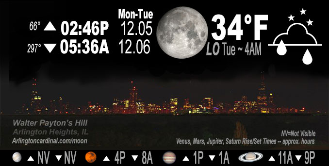
🌔 🌕 🌗 🌑 Waxing Gibbous Moon, sky cover overnight Mon. to Tue. 96% to 99% to 94%, winds WSW to N to NE, 6 to 8 MPH, Low 34, 4a to 7a
NWS CHGO | NWS HRLY | /NWSchicago | 🌡
ARLINGTON HEIGHTS WEATHER
▴ forecast7 (Arl. Hts.) | RADAR | WIDE RADAR
IMPORTANT NOTE ON NWS DATA
======================
Overnight Monday/Tuesday …
No Weather Hazards expected…
DISCUSSION…
The focus on the near-term period will be a couple of periods of light rain/drizzle in the forecast. The first drizzle period will be Monday afternoon/evening mainly across the southeast half of the forecast area and the second later Tuesday afternoon and evening again mainly across the southern areas of Chicagoland. Arlington Heights and the northwest suburbs has a very slight chance of drizzle from 6:00 p.m. to 8:00 p.m. on Monday, and again from 6:00 p.m. to 11:00 p.m. on Tuesday.
Expansive cloud cover will result in a much slower temperature drop tonight, especially underneath lower cloud cover in the southeast half or 2/3 of the area, where lows should remain above freezing. Near and west of the Fox Valley, lows have a better chance to dip to a bit below freezing, with a few pockets of upper 20s if mid clouds erode more than expected.
Fog is not indicated in the forecast, but can’t be ruled out this time of year.
Hello mobile users! If you encounter mobile “unfriendly” weather page, turn your phone sideways for a better view.
======================
O’HARE FORECAST …
Forecast Beginning Monday Night, Dec. 5, 2022
Monday Night: A slight chance of rain or drizzle between 7pm and 10pm. Cloudy, with a low around 33. South southwest wind 5 to 10 mph becoming north northeast after midnight. Chance of precipitation is 20%.
Tuesday: Cloudy, with a high near 43. East northeast wind 5 to 10 mph.
Tuesday Night: A slight chance of rain between 7pm and 1am. Mostly cloudy, with a low around 36. East northeast wind around 5 mph becoming north northwest after midnight. Chance of precipitation is 20%.
Wednesday: Mostly cloudy, with a high near 45. North wind 5 to 10 mph.
Wednesday Night: Mostly cloudy, with a low around 34.
Thursday: A 30 percent chance of rain, mainly after 1pm. Mostly cloudy, with a high near 43.
Thursday Night: Rain likely, mainly after 1am. Cloudy, with a low around 37.
Friday: Rain likely, mainly before 7am. Mostly cloudy, with a high near 39.
Friday Night: Mostly cloudy, with a low around 31.
Saturday: Mostly cloudy, with a high near 40.
Saturday Night: Mostly cloudy, with a low around 29.
Sunday: Partly sunny, with a high near 40.
O’Hare forecast archive and hourly weather observations archive are available HERE on the CARDINAL NEWS Magazine.
Arlingtoncardinal.com/moonphases
Arlingtoncardinal.com/nightsky
NIGHT SKY THIS MONTH …
Check the night sky objects for this month and past months in the playlist from the Space Telescope Science Institute YouTube channel Backyard stargazers get a monthly guide to the northern hemisphere’s skywatching events with “Tonight’s Sky” (Musical track The Far River written by Jonn Serrie, from the album And the Stars Go With You courtesy of New World Music Ltd. Musical track The Far River written by Jonn Serrie, from the album And the Stars Go With You courtesy of New World Music Ltd).
Telephoto lens, ISO 100, f/11, Shutter Speed 1/100 to 1/125 for the Moon.
Get updates from The Cardinal ALL NEWS FEEDS on Facebook. Just ‘LIKE’ the ‘Arlington Cardinal Page (become a fan of our page). The updates cover all posts and sub-category posts from The Cardinal — Arlingtoncardinal.com. You can also limit feeds to specific categories. See all of The Cardinal Facebook fan pages at Arlingtoncardinal.com/about/facebook …
Help fund The Cardinal Arlingtoncardinal.com/sponsor
Telephoto lens, ISO 1600, f/11, Shutter Speed 2.5″ for the skyline. The skyline exposure was toned down, and brightness and contrast was adjusted in Photoshop.
Area Forecast Discussion
National Weather Service Chicago/Romeoville, IL
300 PM CST Mon Dec 5 2022
.SHORT TERM… Issued at 300 PM CST Mon Dec 5 2022
Through Tuesday night…
Key Forecast Message:
* No higher end weather impacts expected
Southerly flow is gradually drawing increased moisture northward this afternoon, most appreciably near and east of a Pontiac to Gary line where the base of the stratus deck ranges from 2000-3500 feet. The most aggressive guidance saturation depth wise this evening appears it will likely have been overdone, precluding a higher chance for drizzle and reduced visibility. That said, did maintained a slight chance of light rain and drizzle east of I-57 this evening as saturation depths and isentropic ascent maximize. A weak cold front will drop southward and shift winds to light north-northeasterly in the late evening and overnight.
Expansive cloud cover will result in a much slower temperature drop tonight, especially underneath lower cloud cover in the southeast half or 2/3 of the area, where lows should remain above freezing. Near and west of the Fox Valley, lows have a better chance to dip to a bit below freezing, with a few pockets of upper 20s if mid clouds erode more than expected. Do not have any fog mention in the grids, but at this time of year, it can`t be ruled out – and will be tied to any localized pockets of clearing.
The main forecast focus on Tuesday is with light mainly PM precipitation chances. If a pretty stout dry wedge aloft can be eroded, a sheared wave may be able to wring out some spotty light rain or even just sprinkles or mangled flurries across portions of far northern Illinois Tuesday afternoon. Measurable light rain chances south of I-80 into the evening are a bit higher relatively speaking, but they too have trended downward. Confined PoPs to lower chance in the southeast 1/3 or so of the area, owing to poor column moisture aloft. It`s possible the spotty light rain ends u Pbeing more drizzly in nature again.
Highs will generally be above normal in the low-mid 40s, with a few 47-48F readings possible per MOS guidance. The low temperatures distribution Tuesday night stands to be fairly similar to that of tonight and temp drop muted by cloud cover.
Castro/NWS Chicago
