
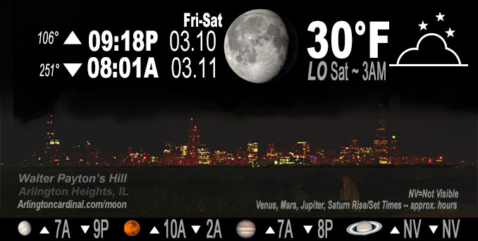
🌖 🌗 🌑 🌓 Waning Gibbous Moon, sky cover overnight Fri. to Sat. 86% to 84%, winds N to NE to E, 8 to 6 MPH, Low 30, 3a to 6a
NWS CHGO | NWS HRLY | /NWSchicago | 🌡
ARLINGTON HEIGHTS WEATHER
▴ forecast7 (Arl. Hts.) | RADAR | WIDE RADAR
IMPORTANT NOTE ON NWS DATA
======================
NIGHT FORECASTS …
NOTE: Keep in mind lunar rise and set times don’t always correspond with night weather and early morning lows because on some days during the month the moon is visible in the sky predominantly during the daytime hours.
Overnight Friday/Saturday …
No Weather Hazards expected
Quiet night, no wind gusts, winter-like cloud cover, and coldest morning low for the past few days at 30°F from 3:00 a.m. to 6:00 a.m.
DISCUSSION…
A recent subjective surface analyses places a 1030mb+ surface high pressure system in northern Ontario with a southward extension of a surface ridge through the western Great Lakes. Meanwhile, upper- level satellite imagery depicts a pair of shortwaves propagating across the western US — the first over eastern Colorado and the second (more vigorous of the two) moving over eastern Montana.
Hello mobile users! If you encounter a mobile “unfriendly” weather page, turn your phone sideways for a better view.
======================
O’HARE FORECAST …
Forecast Beginning Friday Night, Mar. 10, 2023 …
Friday Night: Isolated snow showers before 10pm. Mostly cloudy, with a low around 30. North wind 5 to 15 mph. Chance of precipitation is 20%.
Saturday: Mostly cloudy, with a high near 39. East wind 5 to 10 mph.
Saturday Night: Snow, mainly after 9pm. Low around 32. East southeast wind 10 to 15 mph. Chance of precipitation is 90%. New snow accumulation of 1 to 3 inches possible.
Sunday: A chance of snow before noon, then a chance of rain and snow showers. Cloudy, with a high near 38. East southeast wind 5 to 10 mph becoming west in the afternoon. Chance of precipitation is 40%.
Sunday Night: A 30 percent chance of snow showers, mainly before midnight. Mostly cloudy, with a low around 28.
Monday: A chance of flurries. Mostly cloudy, with a high near 34. Breezy.
Monday Night: Mostly cloudy, with a low around 21.
Tuesday: Sunny, with a high near 34.
Tuesday Night: Mostly clear, with a low around 21.
Wednesday: Partly sunny, with a high near 45.
Wednesday Night: Mostly cloudy, with a low around 38.
Thursday: A chance of rain. Mostly cloudy, with a high near 50.
Thursday Night: A chance of rain. Mostly cloudy, with a low around 34.
Friday: A chance of rain. Partly sunny, with a high near 41.
O’Hare forecast archive and hourly weather observations archive are available HERE on the CARDINAL NEWS Magazine.
Arlingtoncardinal.com/moonphases
Arlingtoncardinal.com/nightsky
NIGHT SKY THIS MONTH …
Check the night sky objects for this month and past months in the playlist from the Space Telescope Science Institute YouTube channel Backyard stargazers get a monthly guide to the northern hemisphere’s skywatching events with “Tonight’s Sky” (Musical track The Far River written by Jonn Serrie, from the album And the Stars Go With You courtesy of New World Music Ltd. Musical track The Far River written by Jonn Serrie, from the album And the Stars Go With You courtesy of New World Music Ltd).
Telephoto lens, ISO 100, f/11, Shutter Speed 1/100 to 1/125 for the Moon.
Get updates from The Cardinal ALL NEWS FEEDS on Facebook. Just ‘LIKE’ the ‘Arlington Cardinal Page (become a fan of our page). The updates cover all posts and sub-category posts from The Cardinal — Arlingtoncardinal.com. You can also limit feeds to specific categories. See all of The Cardinal Facebook fan pages at Arlingtoncardinal.com/about/facebook …
Help fund The Cardinal Arlingtoncardinal.com/sponsor
Telephoto lens, ISO 1600, f/11, Shutter Speed 2.5″ for the skyline. The skyline exposure was toned down, and brightness and contrast was adjusted in Photoshop.
Area Forecast Discussion
National Weather Service Chicago/Romeoville, IL
1105 PM CST Fri Mar 10 2023
.SHORT TERM… Issued at 149 PM CST Fri Mar 10 2023
Through Saturday…
Lingering low level moisture within a steep lapse rate environment continues to support widely scattered shower activity across northeastern IL and into northwestern IN this afternoon. Precipitation type has largely been light snow, though with surface wetbulb temperatures gradually inching above freezing, we could see some rain mix in at times. This activity is likely to continue through the remainder of the afternoon before it begins to wane this evening. No snow accumulation is expected as temperatures will likely continue to hold in the mid to upper 30s into early evening.
A surface ridge of high pressure will build overhead tonight. While temperatures under this high will fall off back below freezing tonight in most areas, continued cloud cover will likely keep readings from falling off too low. The potential coldest spots tonight (readings into the middle 20s) will likely be over northern sections of the area, where a deep snow cover resides. Elsewhere, expect temperatures to bottom out around 30.
The airmass is expected to moderate on Saturday in advance of our next approaching weather system set to impact the area Saturday night into Sunday. This should support a bit warmer weather for Saturday, especially for areas south of the snow covered areas in far northern IL. In fact, readings into the low to mid 40s are possible south of I-80 into the afternoon! Overall, the day looks dry, but precipitation with our next approaching disturbance from the west will be knocking on our door very late in the day.
KJB/NWS Chicago
212 AM CST Sat Mar 11 2023
.SHORT TERM… Issued at 212 AM CST Sat Mar 11 2023
Through Sunday…
A recent subjective surface analyses places a 1030mb+ surface high pressure system in northern Ontario with a southward extension of a surface ridge through the western Great Lakes. Meanwhile, upper- level satellite imagery depicts a pair of shortwaves propagating across the western US — the first over eastern Colorado and the second (more vigorous of the two) moving over eastern Montana. In fact, much of the CONUS is encompassed beneath some degree of cloud cover early this morning, which is a telltale sign of the winter- like pattern currently gripping North America.
With the aforementioned pair of upper-level shortwaves well to our west and surface ridge sliding through this morning, today looks relatively quiet with mostly cloudy skies, light easterly winds, and temperatures in the upper 30s to lower 40s. As the Colorado shortwave moves into the central Plains this afternoon, increasing low-level warm air advection, compact DCVA, and even filaments of low- to mid-level FGEN will support a burgeoning area of precipitation from southern Minnesota to northern Missouri. The leading edge of precipitation should reach western Illinois toward sunset and then I-39 by 10-11 pm, spreading eastward toward Lake Michigan by midnight. Precipitation type at the onset should be rain but cooling of the low-level thermal provide via evaporation into a residual dry layer should support a transition to snow overnight. Forcing for ascent will quickly weaken though the overnight hours as the shortwave gets sheared apart, suggesting snow rates will taper between midnight and daybreak limiting the opportunity for snow accumulations to get out of hand. Indeed, the forecast for 1 to maybe 2″ of snow remains (and perhaps slushy accumulations on roadways).
After daybreak, nebulous forcing for ascent (some remnant from the sheared-out Colorado shortwave and increasing DCVA from the Montana shortwave approaching from the northwest) should force a transition from widespread, stratiform precipitation to that of a more “showery” nature. In addition, rising surface temperatures thanks to increasing low-level advection ahead of the Montana shortwave will change precipitation type to an un-impactful rain/snow grain mix. So, our expectation is for widely scattered rain/snow showers throughout the day on Sunday with little to no impact. Shower coverage should pick up in the afternoon and especially evening along and behind an eastward-surging cold front. In fact, some sort of snow squall-like feature appears poised to develop over northwestern Indiana along the front, which may look more ominous on radar than in actuality owing to surface temperatures well above freezing (e.g. may just pose a threat for brief reductions in visibility and no threat for actual snow accumulations).
Borchardt/NWS Chicago
