
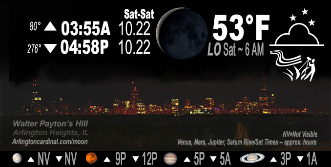
🌘 🌑 🌗 🌕 Waning Crescent Moon, sky cover overnight Fri. to Sat., Clear then a few Clouds, winds S, 13 to 15 to 10 MPH, G24 to 22 to 24 MPH, Low 53, 5a to 7a
NWS CHGO | NWS HRLY | /NWSchicago | 🌡
ARLINGTON HEIGHTS WEATHER
▴ forecast7 (Arl. Hts.) | RADAR | WIDE RADAR
IMPORTANT NOTE ON NWS DATA
======================
No Watches or Warnings overnight Friday to Saturday.
Updates at Arlingtoncardinal.com/NWSChicago
Good stargazing after clouds clear.
======================
O’HARE FORECAST …
Forecast Beginning Friday Night, Oct. 21, 2022
Friday Night Mostly clear, with a low around 54. South southwest wind 10 to 15 mph, with gusts as high as 25 mph.
Saturday Sunny, with a high near 75.
Saturday Night Mostly clear, with a low around 60.
Sunday Mostly sunny, with a high near 75. Breezy.
Sunday Night A chance of showers after 2am. Mostly cloudy, with a low around 61.
Monday A chance of showers. Mostly cloudy, with a high near 72.
Monday Night A chance of showers. Mostly cloudy, with a low around 51.
Tuesday A chance of showers. Mostly sunny, with a high near 60.
Tuesday Night A chance of showers. Mostly cloudy, with a low around 43.
Wednesday Mostly sunny, with a high near 54.
O’Hare forecast archive and hourly weather observations archive are available HERE on the CARDINAL NEWS Magazine.
Arlingtoncardinal.com/moonphases
Arlingtoncardinal.com/nightsky
NIGHT SKY THIS MONTH …
Check the night sky objects for this month and past months in the playlist from the Space Telescope Science Institute YouTube channel Backyard stargazers get a monthly guide to the northern hemisphere’s skywatching events with “Tonight’s Sky” (Musical track The Far River written by Jonn Serrie, from the album And the Stars Go With You courtesy of New World Music Ltd. Musical track The Far River written by Jonn Serrie, from the album And the Stars Go With You courtesy of New World Music Ltd).
Telephoto lens, ISO 100, f/11, Shutter Speed 1/100 to 1/125 for the Moon.
Get updates from The Cardinal ALL NEWS FEEDS on Facebook. Just ‘LIKE’ the ‘Arlington Cardinal Page (become a fan of our page). The updates cover all posts and sub-category posts from The Cardinal — Arlingtoncardinal.com. You can also limit feeds to specific categories. See all of The Cardinal Facebook fan pages at Arlingtoncardinal.com/about/facebook …
Help fund The Cardinal Arlingtoncardinal.com/sponsor
Telephoto lens, ISO 1600, f/11, Shutter Speed 2.5″ for the skyline. The skyline exposure was toned down, and brightness and contrast was adjusted in Photoshop.
Area Forecast Discussion
National Weather Service Chicago/Romeoville, IL
307 AM CDT Sat Oct 22 2022
.SHORT TERM… Issued at 300 AM CDT Sat Oct 22 2022
Through Sunday…
The short term forecast key messages are:
* While not daily records, certainly unseasonable warmth this weekend with 80F to be likely reached today across parts if not much of the forecast area, and possible in a couple spots again Sunday (see Climate Discussion below for further context)
* Breezy today while windy Sunday afternoon when gusts in the 35 mph ballpark are possible; less dry though so a more limited fire weather risk
Early morning GOES-16 imagery depicts a split flow pattern across the CONUS, with quasi-zonal west-southwest flow over the Midwest. A digging northern stream system over the western U.S. today will influence height rises over our region atop a continued pull of anomalously warm low-level air. The setup favors temperatures building on yesterday`s values, especially because readings early this morning are about 15 degrees warmer than 24 hours prior. It can be difficult to predict patches of high cirrus in this pattern, but they should be just that (patches), and have little to no hindrance on full warming. Last evening`s 925 mb temperatures of 19C (ILX) to 22C (DVN) were well initialized by guidance solutions that advertise 19C-20C area-wide today. Using late October climatology for the last 35 years, only nine days came up with such 925 mb warmth, and the average high in Chicago on those days is 78F. With the south winds of 15 mph gusting stronger and sunny skies, see no reason to not lean warmer than that. That`s been the trend the last couple days too, including observed highs being above guidance forecasts. So have 78F to 82F forecast across the area for highs today, which is within the upper quartile of current National Blend of Models (NBM) membership forecast.
Upstream dew points are largely in the 40s through northern Arkansas early this morning, however a majority of short term guidance has that area draw northward quickly this morning. It seems like in these situations with south winds (as opposed to west-southwest) the mixing out of dew points is more limited. We have forecast dew points this afternoon around 50F, which results in humidity values as low as 35 percent. Even accounting for a buffer, this keeps us further from Red Flag Warning concerns than yesterday, and winds are also about 5 mph less.
After a mild evening tonight with lows similar to late August/early September, Sunday will again be very mild with stronger southerly winds. These winds will be in response to the upper trough moving over the intermountain west and a sub 990 mb low taking shape in the western Plains. Some more cirrus is likely and a couple models are showing moistening near 800 mb. If that layer were to be more saturated that could impeded temperatures some, but confidence is high it will still be in the 70s. If clouds are not at all a factor, 80F would be attainable. The stronger winds in the lower troposphere will support afternoon momentum transport of gusts over 30 mph, and possibly a bit over 35 mph depending on degree of mixing, which confidence is lower on at this time.
MTF/NWS Chicago
