
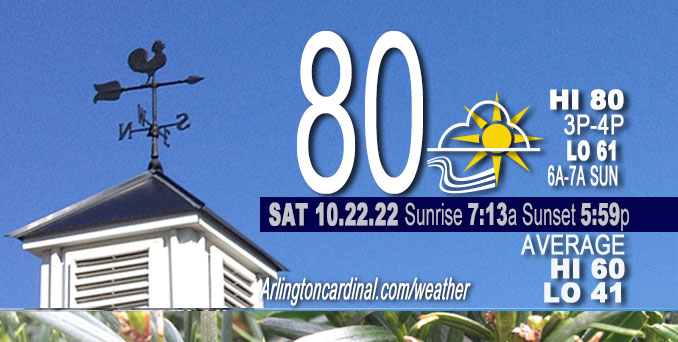
SATURDAY Hi 80°F, mostly sunny, winds S to SSW, 7 to 18 to 16 MPH, G28 to 30 to 26 MPH
NWS CHGO | NWS HRLY | /NWSchicago | 🌡
ARLINGTON HEIGHTS WEATHER
▴ forecast7 (Arl. Hts.) | RADAR | WIDE RADAR
⏪ Hrly Data Table | Hrly Future Graph ⏩
IMPORTANT NOTE ON NWS DATA
⏪ Hrly Data Table | Hrly Future Graph ⏩
======================
No watches or warnings issued near O’Hare at 11:00 a.m. Saturday.
Updates at Arlingtoncardinal.com/NWSChicago
Chicagoland Weather hazards expected…
Wildfire risk is increased in Chicagoland, but Red Flag Warnings are in far northwest Illinois and northeast Iowa
Special Weather Statement
National Weather Service Chicago/Romeoville IL
1010 AM CDT Sat Oct 22 2022
Winnebago-Boone-McHenry-Lake IL-Ogle-Lee-De Kalb-Kane-DuPage- La Salle-Kendall-Grundy-Kankakee-Livingston-Iroquois-Ford- Northern Cook-Central Cook-Southern Cook-Northern Will- Southern Will-Eastern Will-Lake IN-Porter-Newton-Jasper-Benton- Including the cities of Rockford, Belvidere, Crystal Lake, Algonquin, McHenry, Woodstock, Waukegan, Buffalo Grove, Mundelein, Gurnee, Rochelle, Oregon, Byron, Dixon, DeKalb, Sycamore, Aurora, Elgin, Naperville, Wheaton, Downers Grove, Lombard, Carol Stream, Ottawa, Streator, La Salle, Mendota, Marseilles, Oswego, Yorkville, Plano, Morris, Coal City, Minooka, Kankakee, Bourbonnais, Bradley, Pontiac, Dwight, Fairbury, Watseka, Gilman, Paxton, Gibson City, Evanston, Des Plaines, Schaumburg, Palatine, Northbrook, Chicago, Cicero, Oak Lawn, Oak Park, La Grange, Calumet City, Oak Forest, Lemont, Orland Park, Park Forest, Joliet, Bolingbrook, Plainfield, Mokena, Channahon, Manhattan, Wilmington, Crete, Peotone, Beecher, Gary, Hammond, Merrillville, Portage, Valparaiso, Chesterton, Roselawn, Kentland, Morocco, Rensselaer, DeMotte, Fowler, and Oxford 1010 AM CDT Sat Oct 22 2022 /1110 AM EDT Sat Oct 22 2022/
…Fire Danger Again This Afternoon…
The combination of breezy south-southwesterly winds gusting to 25 to 30 mph, along with dry vegetation, will again create a risk for rapid brush and grass fire spread this afternoon.
Avoid open burning and be extra cautious with open flames and smoking materials this afternoon and evening.
Hello mobile users! If you encounter mobile “unfriendly” weather page, turn your phone sideways for a better view.
======================
O’HARE FORECAST …
Forecast Beginning Saturday, Oct. 22, 2022
Today: Sunny, with a high near 80. Breezy, with a south wind 15 to 20 mph, with gusts as high as 30 mph.
Tonight: Mostly clear, with a low around 61. South wind around 15 mph, with gusts as high as 30 mph.
Sunday: Mostly sunny, with a high near 76. Breezy, with a south wind 15 to 20 mph, with gusts as high as 35 mph.
Sunday Night: A chance of showers before 1am, then a chance of showers and thunderstorms between 1am and 4am, then a chance of showers after 4am. Mostly cloudy, with a low around 61. South wind around 15 mph, with gusts as high as 30 mph. Chance of precipitation is 30%.
Monday: A 20 percent chance of showers after 1pm. Mostly cloudy, with a high near 74. South wind around 15 mph, with gusts as high as 30 mph.
Monday Night: Showers likely, mainly after 1am. Mostly cloudy, with a low around 55. Chance of precipitation is 60%.
Tuesday: Showers likely. Cloudy, with a high near 61. Chance of precipitation is 60%.
Tuesday Night: A chance of showers. Mostly cloudy, with a low around 45.
Wednesday: Mostly sunny, with a high near 57.
Wednesday Night: Partly cloudy, with a low around 42.
Thursday: Partly sunny, with a high near 56.
Thursday Night: Mostly cloudy, with a low around 44.
Friday: A chance of showers. Mostly cloudy, with a high near 57.


CHICAGOWEATHERSTATION.COM

ChicagoWeatherStation.com I O’Hare Normal Temps/Precip I O’Hare Record Temps, Precip, Snow
LIVE RADAR | STORM TRACKS | UNISYS US IR SAT | UNISYS Midwest IR SAT | UNISYS More IR SAT
WunderMap® with Temperature/Wind Data || Google: Arlington Heights Area Temps | US TEMPS
Full Screen Motion Weather Radar (Wunderground.com)
Midwest Cloud Cover with Arlington Heights Weather Forecast
ChicagoWeatherStation.com I O’Hare Normal Temps/Precip I O’Hare Record Temps, Precip, Snow
SUNLIGHT DATA FOR SECURITY, TRAFFIC SAFETY, AND SPORTS
SunCalc.net data with solar azimuth and trajectory, times for dawn, sunrise, solar noon, sunset, dusk …
NIGHT SKY THIS MONTH …
Backyard stargazers get a monthly guide to the northern hemisphere’s skywatching events with “Tonight’s Sky.” Check the night sky objects for this month and past months in the playlist from the Space Telescope Science Institute YouTube channel (Musical track The Far River written by Jonn Serrie, from the album And the Stars Go With You courtesy of New World Music Ltd).
Get updates from The Cardinal ALL NEWS FEEDS on Facebook. Just ‘LIKE’ the ‘Arlington Cardinal Page (become a fan of our page). The updates cover all posts and sub-category posts from The Cardinal — Arlingtoncardinal.com. You can also limit feeds to specific categories. See all of The Cardinal Facebook fan pages at Arlingtoncardinal.com/about/facebook …
Help fund The Cardinal Arlingtoncardinal.com/sponsor
Area Forecast Discussion
National Weather Service Chicago/Romeoville, IL
639 AM CDT Sat Oct 22 2022
.SHORT TERM…
Issued at 300 AM CDT Sat Oct 22 2022
Through Sunday…
The short term forecast key messages are:
* While not daily records, certainly unseasonable warmth this weekend with 80F to be likely reached today across parts if not much of the forecast area, and possible in a couple spots again Sunday (see Climate Discussion below for further context)
* Breezy today while windy Sunday afternoon when gusts in the 35 mph ballpark are possible; less dry though so a more limited fire weather risk
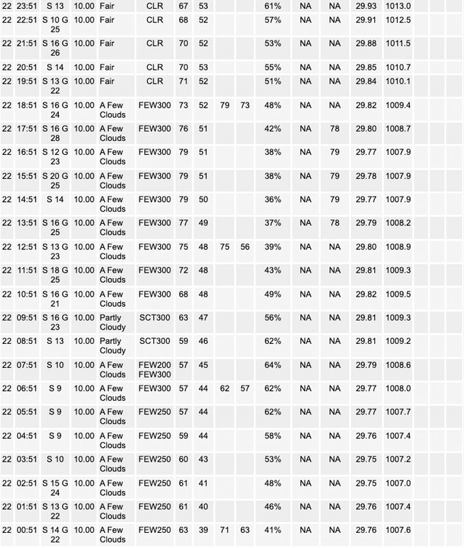
Early morning GOES-16 imagery depicts a split flow pattern across the CONUS, with quasi-zonal west-southwest flow over the Midwest. A digging northern stream system over the western U.S. today will influence height rises over our region atop a continued pull of anomalously warm low-level air. The setup favors temperatures building on yesterday`s values, especially because readings early this morning are about 15 degrees warmer than 24 hours prior. It can be difficult to predict patches of high cirrus in this pattern, but they should be just that (patches), and have little to no hindrance on full warming. Last evening`s 925 mb temperatures of 19C (ILX) to 22C (DVN) were well initialized by guidance solutions that advertise 19C-20C area-wide today. Using late October climatology for the last 35 years, only nine days came up with such 925 mb warmth, and the average high in Chicago on those days is 78F. With the south winds of 15 mph gusting stronger and sunny skies, see no reason to not lean warmer than that. That`s been the trend the last couple days too, including observed highs being above guidance forecasts. So have 78F to 82F forecast across the area for highs today, which is within the upper quartile of current National Blend of Models (NBM) membership forecast.
Upstream dew points are largely in the 40s through northern Arkansas early this morning, however a majority of short term guidance has that area draw northward quickly this morning. It seems like in these situations with south winds (as opposed to west-southwest) the mixing out of dew points is more limited. We have forecast dew points this afternoon around 50F, which results in humidity values as low as 35 percent. Even accounting for a buffer, this keeps us further from Red Flag Warning concerns than yesterday, and winds are also about 5 mph less.
After a mild evening tonight with lows similar to late August/early September, Sunday will again be very mild with stronger southerly winds. These winds will be in response to the upper trough moving over the intermountain west and a sub 990 mb low taking shape in the western Plains. Some more cirrus is likely and a couple models are showing moistening near 800 mb. If that layer were to be more saturated that could impeded temperatures some, but confidence is high it will still be in the 70s. If clouds are not at all a factor, 80F would be attainable. The stronger winds in the lower troposphere will support afternoon momentum transport of gusts over 30 mph, and possibly a bit over 35 mph depending on degree of mixing, which confidence is lower on at this time.
MTF/NWS Chicago
