
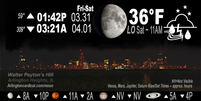
🌔 🌕 🌗 🌑 Waxing Gibbous Moon, sky cover overnight Fri. to Sat. 90% to 29% to 70%, winds SW to WSW to W, 22 to 29 to 25 MPH, G36 to 44 to 38 MPH, Low 38, 7a to 10a
NWS CHGO | NWS HRLY | /NWSchicago | 🌡
ARLINGTON HEIGHTS WEATHER
▴ forecast7 (Arl. Hts.) | RADAR | WIDE RADAR
IMPORTANT NOTE ON NWS DATA
Hello mobile users! If you encounter a mobile “unfriendly” weather page, turn your phone sideways for a better view.
======================
NIGHT FORECASTS …
NOTE: Keep in mind lunar rise and set times don’t always correspond with night weather and early morning lows because on some days during the month the moon is visible in the sky predominantly during the daytime hours.
Overnight Friday/Saturday …
Weather Hazards expected …
Flood Watch in effect from March 31, 07:01 PM CDT until April 1, 12:00 AM CDT
Wind Advisory in effect from March 31, 10:00 PM CDT until April 1, 01:00 PM CDT
Flash Flood Warning in effect from March 31, 07:09 PM CDT until March 31, 11:00 PM CDT
Tornado Watch in effect from March 31, 02:35 PM CDT until March 31, 10:00 PM CDT
Flood Advisory in effect from March 31, 06:09 PM CDT until March 31, 10:00 PM CDT
Severe Thunderstorm Warning in effect from March 31, 07:52 PM CDT until March 31, 09:00 PM CDT
DISCUSSION…
Thunderstorms are expected late tonight. While severe weather is not anticipated, some of the strongest storms may produce small hail. South winds will also gust to 35 mph overnight.
RELATED NEWS …
======================
O’HARE FORECAST …
Forecast Beginning Friday Night, Mar. 31, 2023 …
Friday Night: Showers and thunderstorms before 11pm, then a slight chance of showers after 4am. Some of the storms could be severe. Low around 36. Breezy, with a southwest wind 20 to 25 mph, with gusts as high as 45 mph. Chance of precipitation is 100%. New precipitation amounts between a half and three quarters of an inch possible.
Saturday: Rain and snow showers likely, mainly before 10am. Cloudy, then gradually becoming mostly sunny, with a high near 41. Breezy, with a west southwest wind 15 to 25 mph becoming north northwest in the afternoon. Winds could gust as high as 45 mph. Chance of precipitation is 60%. Little or no snow accumulation expected.
Saturday Night: Mostly clear, with a low around 28. North wind 5 to 10 mph becoming south southeast after midnight. Winds could gust as high as 20 mph.
Sunday: Mostly sunny, with a high near 57. Breezy, with a south wind 5 to 10 mph increasing to 15 to 20 mph in the afternoon. Winds could gust as high as 30 mph.
Sunday Night: Partly cloudy, with a low around 44. Breezy.
Monday: A 40 percent chance of rain after 1pm. Partly sunny, with a high near 61.
Monday Night: Rain likely. Mostly cloudy, with a low around 43.
Tuesday: Rain likely, with thunderstorms also possible after 1pm. Mostly cloudy, with a high near 65.
Tuesday Night: Rain and possibly a thunderstorm before 1am, then rain likely. Mostly cloudy, with a low around 48. Breezy.
Wednesday: A chance of rain. Mostly sunny, with a high near 61. Breezy.
Wednesday Night: Mostly clear, with a low around 32. Breezy.
Thursday: Mostly sunny, with a high near 49.
O’Hare forecast archive and hourly weather observations archive are available HERE on the CARDINAL NEWS Magazine.
Arlingtoncardinal.com/moonphases
Arlingtoncardinal.com/nightsky
NIGHT SKY THIS MONTH …
Check the night sky objects for this month and past months in the playlist from the Space Telescope Science Institute YouTube channel Backyard stargazers get a monthly guide to the northern hemisphere’s skywatching events with “Tonight’s Sky” (Musical track The Far River written by Jonn Serrie, from the album And the Stars Go With You courtesy of New World Music Ltd. Musical track The Far River written by Jonn Serrie, from the album And the Stars Go With You courtesy of New World Music Ltd).
Telephoto lens, ISO 100, f/11, Shutter Speed 1/100 to 1/125 for the Moon.
Get updates from The Cardinal ALL NEWS FEEDS on Facebook. Just ‘LIKE’ the ‘Arlington Cardinal Page (become a fan of our page). The updates cover all posts and sub-category posts from The Cardinal — Arlingtoncardinal.com. You can also limit feeds to specific categories. See all of The Cardinal Facebook fan pages at Arlingtoncardinal.com/about/facebook …
Help fund The Cardinal Arlingtoncardinal.com/sponsor
Telephoto lens, ISO 1600, f/11, Shutter Speed 2.5″ for the skyline. The skyline exposure was toned down, and brightness and contrast was adjusted in Photoshop.
/////////////>
Area Forecast Discussion
National Weather Service Chicago/Romeoville, IL
838 PM CDT Fri Mar 31 2023
.MESOSCALE DISCUSSION… Issued at 837 PM CDT Fri Mar 31 2023
The severe weather threat continues east of I-55 through around 10 PM. While the original quasi-linear convective system (QLCS) has weakened a smidge, the straight-line winds have regularly produced severe level gusts and continued scattered damage into the Chicago metro. Severe winds of 70+ mph remain favored. Also, the mesovortexgenesis threat continues for at least short-lived tornadoes, and seeing an area in far southern Cook County/eastern Will County that seems to be intersecting a boundary and/or interacting with some reflectivity tags that has had at least some circulation behavior. At the least, enhanced winds near 80 mph will be possible with this as it continues into Lake County Indiana and likely Porter County too.
To the southeast, the persistent rotating storm in Benton County has had a tornado at times in Illinois based on reports and especially radar-confirmed debris signatures. This has almost been a combination of a supercell and a bookend-like convective cluster. There are some favorable ingredients for a significant tornado there before it exits Benton and far southern Jasper County through 915 PM, highlighted at the least by STP values of 4+. In particular, the communities of Remington and Otterbein need to watch this closely. Farther north toward the Kankakee River Valley, it`s a bit more muddy of a mode, but has been occasional supercell structures and could see some isolated damaging winds.
MTF/NWS Chicago
&&
.SHORT TERM… Issued at 322 PM CDT Fri Mar 31 2023
Through Saturday night…
For details on thunderstorm trends through the remainder of this afternoon and evening, see the latest mesoscale forecast discussion above.
990 mb surface low over central IA at mid-afternoon is expected to continue to deepen slightly as it moves east-northeast across south central WI and central LM to northern lower MI through Saturday morning. In the process, a sharp cold front will push quickly across the forecast area this evening. as will an initial strong mid-level vort. Strong subsidence and drying is expected behind these features during the late evening and early overnight hours, with a quick end to thunderstorms and showers. The main concern during this period, is for strong west-southwest winds behind the front, with a combination of strong surface pressure rises and a deepening boundary layer within a low-level cold advection regime characterized by steep low level lapse rates supporting wind gusts in the 40-45 kt (wind advisory) range. While areas along/south of the I-80 corridor would appear to have the better potential for prolonged advisory criteria winds overnight into Saturday morning, latest guidance soundings suggest at least some potential to tap into 40+ kt gusts for a time overnight as well. Based on this have expanded our wind advisory north to the IL/WI state line (though with a later 10 pm start time behind the cold front). All wind headlines will continue through 1 pm Saturday, with northwest winds gradually diminishing through the afternoon and evening.
A secondary stout mid-level vort is progged to wrap eastward across the forecast area early Saturday, coincident with a secondary surface trough and renewed advection of low-level moisture from the northwest. Along with the steep low-level lapse rates, this would support rain/snow showers. Surface temps are forecast to settle into the mid-upper 30s during this time, which may support brief all-snow showers (especially near the IL/WI border) and some spotty minor accums. Warm ground temps and air temps trending back up toward 40 degree should melt anything which might accumulate by afternoon. Surface high pressure then builds east into the area Saturday evening, with diminishing winds and clearing skies.
Ratzer/NWS Chicago
