
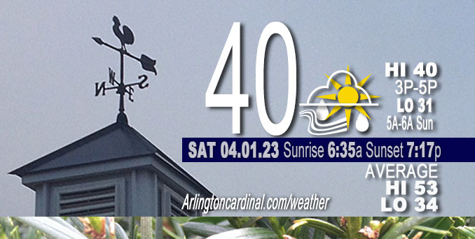
Saturday Hi 40, mostly cloudy to partly cloudy, winds W to NW, 18 to 26 to 5 MPH, G29 to 36 to 16 MPH, until 8p
NWS CHGO | NWS HRLY | /NWSchicago | 🌡
ARLINGTON HEIGHTS WEATHER
▴ forecast7 (Arl. Hts.) | RADAR | WIDE RADAR
⏪ Hrly Data Table | Hrly Future Graph ⏩
IMPORTANT NOTE ON NWS DATA
⏪ Hrly Data Table | Hrly Future Graph ⏩
Hello mobile users! If you encounter a mobile “unfriendly” weather page, turn your phone sideways for a better view.
======================
Saturday and Saturday Evening …
No Weather Hazards expected …
DISCUSSION…
Gusty northerly winds and extensive cloud cover continue to result in a rather raw April 1 for the area, as surface temperatures struggle to warm into the lower 40s. Fortunately, the cloud cover and surface winds will decrease across the area this evening as a surface ridge of high pressure shifts overhead. This will support a chilly night across the area as the surface temperatures drop into the upper 20s to low 30s. Sunday warmup thanks to a return to breezy south winds and increased sunshine.
======================
O’HARE FORECAST …
Forecast Beginning Saturday, Apr. 01, 2023
Saturday: Cloudy, with a high near 42. Breezy, with a north northwest wind around 20 mph, with gusts as high as 30 mph.
Saturday Night: Cloudy during the early evening, then gradual clearing, with a low around 31. North northwest wind 5 to 15 mph becoming east southeast after midnight. Winds could gust as high as 20 mph.
Sunday: Mostly sunny, with a high near 58. Breezy, with a south wind 5 to 10 mph increasing to 15 to 20 mph in the afternoon. Winds could gust as high as 30 mph.
Sunday Night: Mostly clear, with a low around 43. Breezy, with a south wind 15 to 20 mph decreasing to 5 to 10 mph after midnight. Winds could gust as high as 30 mph.
Monday: A 50 percent chance of showers, mainly after 1pm. Mostly cloudy, with a high near 56. West wind around 5 mph becoming east in the afternoon.
Monday Night: Showers likely and possibly a thunderstorm. Cloudy, with a low around 43. Chance of precipitation is 70%.
Tuesday: A chance of showers before 10am, then a chance of showers and thunderstorms between 10am and 1pm, then showers likely and possibly a thunderstorm after 1pm. Mostly cloudy, with a high near 67. Chance of precipitation is 70%.
Tuesday Night: Showers and possibly a thunderstorm. Mostly cloudy, with a low around 52. Breezy.
Wednesday: A chance of showers before 1pm. Mostly sunny, with a high near 60. Windy.
Wednesday Night: Mostly clear, with a low around 30. Breezy.
Thursday: Sunny, with a high near 48. Breezy.
Thursday Night: Mostly clear, with a low around 32.
Friday: Mostly sunny, with a high near 50.


CHICAGOWEATHERSTATION.COM

ChicagoWeatherStation.com I O’Hare Normal Temps/Precip I O’Hare Record Temps, Precip, Snow
LIVE RADAR | STORM TRACKS | UNISYS US IR SAT | UNISYS Midwest IR SAT | UNISYS More IR SAT
WunderMap® with Temperature/Wind Data || Google: Arlington Heights Area Temps | US TEMPS
Full Screen Motion Weather Radar (Wunderground.com)
Midwest Cloud Cover with Arlington Heights Weather Forecast
ChicagoWeatherStation.com I O’Hare Normal Temps/Precip I O’Hare Record Temps, Precip, Snow
SUNLIGHT DATA FOR SECURITY, TRAFFIC SAFETY, AND SPORTS
SunCalc.net data with solar azimuth and trajectory, times for dawn, sunrise, solar noon, sunset, dusk …
NIGHT SKY THIS MONTH …
Backyard stargazers get a monthly guide to the northern hemisphere’s skywatching events with “Tonight’s Sky.” Check the night sky objects for this month and past months in the playlist from the Space Telescope Science Institute YouTube channel (Musical track The Far River written by Jonn Serrie, from the album And the Stars Go With You courtesy of New World Music Ltd).
Get updates from The Cardinal ALL NEWS FEEDS on Facebook. Just ‘LIKE’ the ‘Arlington Cardinal Page (become a fan of our page). The updates cover all posts and sub-category posts from The Cardinal — Arlingtoncardinal.com. You can also limit feeds to specific categories. See all of The Cardinal Facebook fan pages at Arlingtoncardinal.com/about/facebook …
Help fund The Cardinal Arlingtoncardinal.com/sponsor
/////////////>
Area Forecast Discussion
National Weather Service Chicago/Romeoville, IL
618 AM CDT Sat Apr 1 2023
.SHORT TERM… Issued at 230 AM CDT Sat Apr 1 2023
Through Sunday…
Forecast concerns include wind gusts through this afternoon and the potential for a rain/snow mix this morning.
Winds have briefly diminished early this morning but are expected to increase toward daybreak as the gradient tightens again ahead of a cold front that will move across the area later this morning. Wind gusts into the 45-50 mph range still look possible and not planning any changes to the wind advisory. Speeds and gusts are expected to steadily diminish during the afternoon with a short period of light and variable possible this evening as a ridge of high pressure moves across the region. Winds will turn southerly by Sunday morning and are expected to gust into the 30 mph range Sunday afternoon.
There still remains uncertainty for rain and snow coverage this morning. Most of guidance shows a slow weakening trend as the precipitation moves across northern IL with perhaps the best chance of mainly wet snow across northwest and far northern IL, where minor accumulation on grassy surfaces is possible, if the snow falls heavily enough. But with marginal air temps and the warm ground, not expecting any impacts on roadways and the preci Pmay be more of a mix of rain/snow. This activity will shift east by early afternoon, across northwest IN.
CMS/NWS Chicago
