
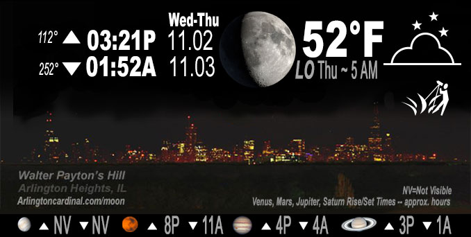
🌔 🌕 🌗 🌑 Waxing Gibbous Moon, sky cover overnight Wed. to Thu. 3% to 27% to 26%, winds SSE to S, 8 MPH, G13 11p to 7a, Low 52, 5a to 7a
NWS CHGO | NWS HRLY | /NWSchicago | 🌡
ARLINGTON HEIGHTS WEATHER
▴ forecast7 (Arl. Hts.) | RADAR | WIDE RADAR
IMPORTANT NOTE ON NWS DATA
======================
Wednesday night …
No Weather hazards expected…
DISCUSSION…
Some gusty winds overnight before a windier day on Thursday compared to the last couple of days. Slight in crease in clouds toward morning.
======================
O’HARE FORECAST …
Forecast Beginning Wednesday Night, Nov. 02, 2022
Wednesday Night: Mostly clear, with a low around 52. South wind around 10 mph.
Thursday: Mostly sunny, with a high near 74. Breezy, with a south wind 10 to 20 mph, with gusts as high as 30 mph.
Thursday Night: Mostly cloudy, with a low around 60. South wind around 15 mph, with gusts as high as 30 mph.
Friday: A 50 percent chance of rain. Mostly cloudy, with a high near 71. South wind around 15 mph, with gusts as high as 30 mph.
Friday Night: Rain, mainly after 1am. Low around 55. South wind around 15 mph, with gusts as high as 30 mph. Chance of precipitation is 80%.
Saturday: Rain likely, mainly before 1pm. Mostly cloudy, with a high near 63. Breezy. Chance of precipitation is 60%.
Saturday Night: Partly cloudy, with a low around 44.
Sunday: Sunny, with a high near 63.
Sunday Night: Mostly clear, with a low around 45.
Monday: Sunny, with a high near 59.
Monday Night: Partly cloudy, with a low around 47.
Tuesday: Mostly sunny, with a high near 62.
Tuesday Night: Partly cloudy, with a low around 49.
Wednesday: Mostly sunny, with a high near 64.
O’Hare forecast archive and hourly weather observations archive are available HERE on the CARDINAL NEWS Magazine.
Arlingtoncardinal.com/moonphases
Arlingtoncardinal.com/nightsky
NIGHT SKY THIS MONTH …
Check the night sky objects for this month and past months in the playlist from the Space Telescope Science Institute YouTube channel Backyard stargazers get a monthly guide to the northern hemisphere’s skywatching events with “Tonight’s Sky” (Musical track The Far River written by Jonn Serrie, from the album And the Stars Go With You courtesy of New World Music Ltd. Musical track The Far River written by Jonn Serrie, from the album And the Stars Go With You courtesy of New World Music Ltd).
Telephoto lens, ISO 100, f/11, Shutter Speed 1/100 to 1/125 for the Moon.
Get updates from The Cardinal ALL NEWS FEEDS on Facebook. Just ‘LIKE’ the ‘Arlington Cardinal Page (become a fan of our page). The updates cover all posts and sub-category posts from The Cardinal — Arlingtoncardinal.com. You can also limit feeds to specific categories. See all of The Cardinal Facebook fan pages at Arlingtoncardinal.com/about/facebook …
Help fund The Cardinal Arlingtoncardinal.com/sponsor
Telephoto lens, ISO 1600, f/11, Shutter Speed 2.5″ for the skyline. The skyline exposure was toned down, and brightness and contrast was adjusted in Photoshop.
Area Forecast Discussion
National Weather Service Chicago/Romeoville, IL
642 PM CDT Wed Nov 2 2022
.SHORT TERM…
Issued at 322 PM CDT Wed Nov 2 2022
Through Thursday night…
All is quiet here locally for time being as we find ourselves on the western periphery of an expansive ridge that encompasses much of the eastern half of the CONUS. Abundant sunshine and broad, modest warm air advection off of southerly winds have gifted us a gorgeous early November day with temperatures currently (as of 3 PM CDT) in the low-mid 70s pretty much area-wide, though about a 20-25 degree drop-off in temperatures can be expected tonight into Thursday morning. While some of the more aggressive guidance tries to develo Pat least patchy fog overnight, low-level flow should remain just strong enough to keep this from being much of any concern.
The eastern CONUS ridge will slowly slug its way eastward as we head into Thursday as a deepening upper-level trough over the western CONUS continues to push southeastward towards the southern Plains. A region of surface low pressure currently centered over the northern Plains and southern Canadian Prairies will have shifted eastward into Ontario towards James Bay come the daytime hours on Thursday, while the western upper-level trough spurs additional surface pressure falls across the Great Plains. As a result of all this, we will find ourselves sandwiched between the elongated surface trough to our north and west and the slowly departing surface ridge to our east on Thursday, which will lead to a tightened low-level pressure gradient over the region that will foster an extended period of breezy southerly to south- southwesterly winds beginning Thursday morning and continuing until a cold frontal passage early this weekend. For Thursday, though, sustained winds around 20 mph with gusts closer to 30 mph look like a good bet, especially across the northwestern half of our CWA, where isobars will be a little more compact than they will be further east.
With the warm air advection continuing (and increasing in magnitude) and slightly deeper mixing expected tomorrow, temperatures will once again climb into the low-mid 70s by the mid-afternoon hours. Increasing high cloud cover towards the afternoon should prevent tomorrow`s temperatures from getting too much higher than they got today, but nevertheless, they could still make a run at the daily record high temperatures for November 3rd, especially for Chicago (more on that in the Climate portion of the AFD below). The elevated low-level flow should remain sustained beyond sunset on Thursday, which will result in a breezy and unseasonably mild night featuring record or near-record warm minimum temperatures
for November 4th.
Ogorek/NWS Chicago
