
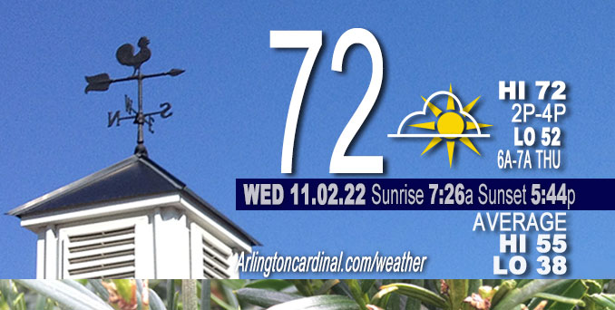
WEDNESDAY Hi 72°F, mostly sunny, winds S to SSE to S, 8 to 10 to 8 MPH, G13 after 9p
NWS CHGO | NWS HRLY | /NWSchicago | 🌡
ARLINGTON HEIGHTS WEATHER
▴ forecast7 (Arl. Hts.) | RADAR | WIDE RADAR
⏪ Hrly Data Table | Hrly Future Graph ⏩
IMPORTANT NOTE ON NWS DATA
⏪ Hrly Data Table | Hrly Future Graph ⏩
======================
No Weather hazards expected…
DISCUSSION…
Full sunshine should result in high temperatures in the lower 70s across most of the forecast area. A stray 74-75 degree reading is even possible across in western Chicagoland
(or even the warmest Chicago urban sites like Midway International Airport).
Hello mobile users! If you encounter mobile “unfriendly” weather page, turn your phone sideways for a better view.
======================
O’HARE FORECAST …
Forecast Beginning Wednesday, Nov. 02, 2022
Today: Sunny, with a high near 72. South wind 5 to 10 mph.
Tonight: Mostly clear, with a low around 52. South southeast wind 5 to 10 mph.
Thursday: Mostly sunny, with a high near 72. South wind 10 to 15 mph, with gusts as high as 25 mph.
Thursday Night: Mostly cloudy, with a low around 59. South wind around 15 mph, with gusts as high as 25 mph.
Friday: A 40 percent chance of rain after 8am. Cloudy, with a high near 70. South wind around 15 mph, with gusts as high as 25 mph.
Friday Night: Rain, mainly after 2am. Low around 57. Chance of precipitation is 80%.
Saturday: Rain, mainly before 2pm. High near 64. Breezy. Chance of precipitation is 80%.
Saturday Night: A chance of rain before 2am. Mostly cloudy, with a low around 46. Breezy.
Sunday: Sunny, with a high near 62.
Sunday Night: Mostly clear, with a low around 45.
Monday: Sunny, with a high near 60.
Monday Night: Partly cloudy, with a low around 47.
Tuesday: A chance of rain. Partly sunny, with a high near 62.


CHICAGOWEATHERSTATION.COM

ChicagoWeatherStation.com I O’Hare Normal Temps/Precip I O’Hare Record Temps, Precip, Snow
LIVE RADAR | STORM TRACKS | UNISYS US IR SAT | UNISYS Midwest IR SAT | UNISYS More IR SAT
WunderMap® with Temperature/Wind Data || Google: Arlington Heights Area Temps | US TEMPS
Full Screen Motion Weather Radar (Wunderground.com)
Midwest Cloud Cover with Arlington Heights Weather Forecast
ChicagoWeatherStation.com I O’Hare Normal Temps/Precip I O’Hare Record Temps, Precip, Snow
SUNLIGHT DATA FOR SECURITY, TRAFFIC SAFETY, AND SPORTS
SunCalc.net data with solar azimuth and trajectory, times for dawn, sunrise, solar noon, sunset, dusk …
NIGHT SKY THIS MONTH …
Backyard stargazers get a monthly guide to the northern hemisphere’s skywatching events with “Tonight’s Sky.” Check the night sky objects for this month and past months in the playlist from the Space Telescope Science Institute YouTube channel (Musical track The Far River written by Jonn Serrie, from the album And the Stars Go With You courtesy of New World Music Ltd).
Get updates from The Cardinal ALL NEWS FEEDS on Facebook. Just ‘LIKE’ the ‘Arlington Cardinal Page (become a fan of our page). The updates cover all posts and sub-category posts from The Cardinal — Arlingtoncardinal.com. You can also limit feeds to specific categories. See all of The Cardinal Facebook fan pages at Arlingtoncardinal.com/about/facebook …
Help fund The Cardinal Arlingtoncardinal.com/sponsor
Area Forecast Discussion
National Weather Service Chicago/Romeoville, IL
620 AM CDT Wed Nov 2 2022
.SHORT TERM…
Issued at 335 AM CDT Wed Nov 2 2022
Correction to record highs for today at end of third paragraph.
Through Thursday…
Forecast highlights through the near term period include some minor patchy fog early this morning, well-above average warmth, and increasing south winds on Thursday.
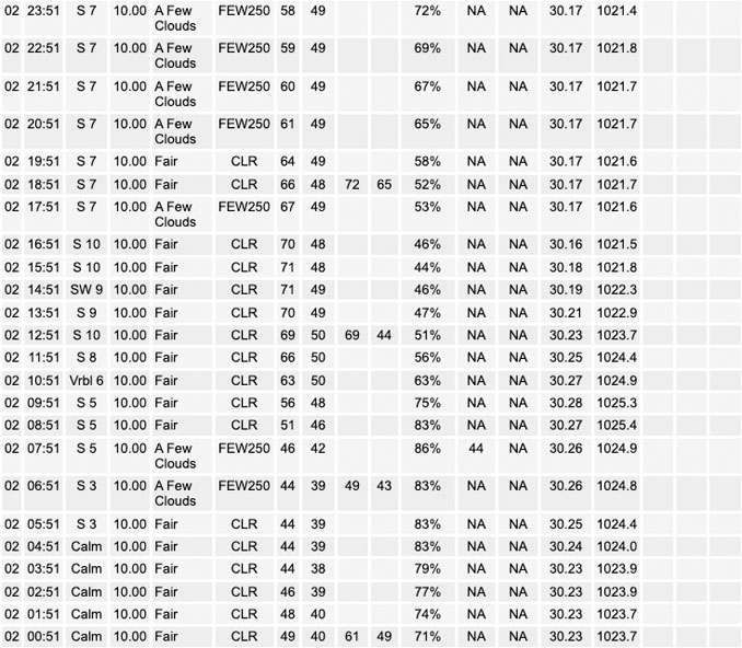
Early morning surface analysis depicts 997 mb low pressure over eastern Montana, and high pressure ridging from Ontario through the central and eastern Great Lakes. A lingering low-level moisture gradient remains across our forecast area, with surface dew points still in the lower 40s mainly along/east of the I-55 corridor this morning. This, coupled with lighter/calm winds closer to the surface ridge to our east, has allowed some patchy shallow fog development in spots. Lansing, Gary and Valparaiso airports have all flirted with 1SM or less visibility early this morning, however drier ground conditions after yesterday`s sunshine appear to be limiting coverage of denser fog. Not expecting widespread dense fog to the degree an advisory would be needed this morning. Northwest of I-55, lower dew points and a little more wind at the top of the shallow nocturnal inversion should prevent much in the way of fog except perhaps in a few typical sheltered/low spots.
The aforementioned Montana low was developing in response to a digging and amplifying western CONUS upper trough, which was also inducing downstream southwesterly flow aloft across the Plains and the Midwest. Within this flow was a mid-level short wave was centered over southeast Missouri, which will propagate east- northeast across the lower Ohio and Tennessee river valleys today. For our local forecast area, we`ll only be along the far northern periphery of this disturbance`s cirrus shield which will barely glance our southeast counties through midday or early afternoon. Otherwise sunny skies are in store for the area, along with modest southerly winds developing in response to the deep low well to our northwest. With low level warm advection gradually strengthening today, our full sunshine should result in high temperatures in the lower 70s across most of the forecast area. A stray 74-75 degree reading is even possible across our western cwa (or even our warmest Chicago urban sites like MDW), where model 925 mb temps approach 15C early this afternoon. This is 15-20 degrees above average for early of November, as average highs for today are generally in the mid-50s. Record highs for today are 76 for Rockford and 78 for Chicago.
The surface pressure gradient gradually tightens across the region tonight, maintaining south winds around 10 mph which will keep temperatures from dropping off below 45-50 degrees. Winds may even remain or become a bit breezy overnight, especially across the northwest half of the cwa as a 30+ kt 925 mb low level jet develops above the more-stable boundary layer. Southerly winds continue to strengthen Thursday as the gradient tightens further, and gusts to 30+ mph are likely during the afternoon especially across the northwest half of the forecast area. Despite a little more patchy high clouds than today, 70+ degree warmth will continue.
Ratzer/NWS Chicago
