
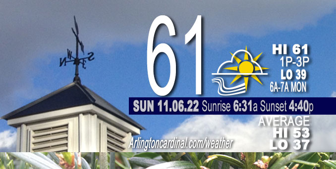
SUNDAY Hi 61, partly sunny, clearing after 8a, winds SW to W to WNW, 11 to 18 to 8 MPH, G17 to 33 to 14 MPH, 4a to 6p
NWS CHGO | NWS HRLY | /NWSchicago | 🌡
ARLINGTON HEIGHTS WEATHER
▴ forecast7 (Arl. Hts.) | RADAR | WIDE RADAR
⏪ Hrly Data Table | Hrly Future Graph ⏩
IMPORTANT NOTE ON NWS DATA
⏪ Hrly Data Table | Hrly Future Graph ⏩
======================
Weather hazards expected Sunday…
This Hazardous Weather Outlook is for portions of North Central Illinois…Northeast Illinois and Northwest Indiana.
Sunday and Sunday Night …
Weather hazards expected…
Limited Non Thunderstorm Wind Risk, mainly near the Wisconsin state line.
DISCUSSION…
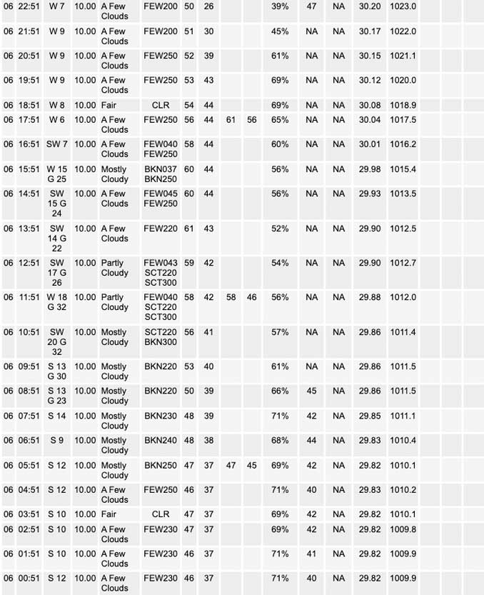
Breezy winds will again develop this morning near the Wisconsin state line and abate during the afternoon. The winds will not be as strong as yesterday, with peak gusts in the range of 30 to 35 mph.
Hello mobile users! If you encounter mobile “unfriendly” weather page, turn your phone sideways for a better view.
======================
O’HARE FORECAST …
Forecast Beginning Sunday, Nov. 06, 2022
Sunday: Partly sunny, then gradually becoming sunny, with a high near 61. Breezy, with a south southwest wind 10 to 20 mph, with gusts as high as 35 mph.
Sunday Night: Mostly clear, with a low around 39. West southwest wind 5 to 10 mph.
Monday: Sunny, with a high near 55. Northwest wind 5 to 10 mph becoming north northeast in the afternoon. Winds could gust as high as 15 mph.
Monday Night: Partly cloudy, with a low around 42. East northeast wind 5 to 10 mph, with gusts as high as 15 mph.
Tuesday: Partly sunny, with a high near 56. East southeast wind 10 to 15 mph.
Tuesday Night: Mostly cloudy, with a low around 46.
Wednesday: Mostly sunny, with a high near 69.
Wednesday Night: Partly cloudy, with a low around 58.
Thursday: Partly sunny, with a high near 71.
Thursday Night: A chance of showers. Mostly cloudy, with a low around 42.
Veterans Day: Mostly sunny, with a high near 48.
Friday Night: Partly cloudy, with a low around 28.
Saturday: Partly sunny, with a high near 38.


CHICAGOWEATHERSTATION.COM

ChicagoWeatherStation.com I O’Hare Normal Temps/Precip I O’Hare Record Temps, Precip, Snow
LIVE RADAR | STORM TRACKS | UNISYS US IR SAT | UNISYS Midwest IR SAT | UNISYS More IR SAT
WunderMap® with Temperature/Wind Data || Google: Arlington Heights Area Temps | US TEMPS
Full Screen Motion Weather Radar (Wunderground.com)
Midwest Cloud Cover with Arlington Heights Weather Forecast
ChicagoWeatherStation.com I O’Hare Normal Temps/Precip I O’Hare Record Temps, Precip, Snow
SUNLIGHT DATA FOR SECURITY, TRAFFIC SAFETY, AND SPORTS
SunCalc.net data with solar azimuth and trajectory, times for dawn, sunrise, solar noon, sunset, dusk …
NIGHT SKY THIS MONTH …
Backyard stargazers get a monthly guide to the northern hemisphere’s skywatching events with “Tonight’s Sky.” Check the night sky objects for this month and past months in the playlist from the Space Telescope Science Institute YouTube channel (Musical track The Far River written by Jonn Serrie, from the album And the Stars Go With You courtesy of New World Music Ltd).
Get updates from The Cardinal ALL NEWS FEEDS on Facebook. Just ‘LIKE’ the ‘Arlington Cardinal Page (become a fan of our page). The updates cover all posts and sub-category posts from The Cardinal — Arlingtoncardinal.com. You can also limit feeds to specific categories. See all of The Cardinal Facebook fan pages at Arlingtoncardinal.com/about/facebook …
Help fund The Cardinal Arlingtoncardinal.com/sponsor
Area Forecast Discussion
National Weather Service Chicago/Romeoville, IL
240 AM CST Sun Nov 6 2022
.SHORT TERM…
Issued at 1253 AM CDT Sun Nov 6 2022
Through Sunday…
All is quiet on the home front after a windy and arguably chilly Saturday. Generally quiet weather is now in store through the next 48 hours.
Regional satellite imagery depicts a trio of storm systems across southern Canada within an expansive baroclinic zone draped across North America. The first system is along the Atlantic Coast of British Columbia; the second along the North Dakota/Canadian border, and third along the Ontario/Quebec border. As the furthest-west system of the trio digs into the northwestern United States today and tomorrow, expansive differential warm-air advection with respect to height into the northern Plains will “flatten” out the “middle” system along the North Dakota/US border and force the development of a surface high pressure system across the northern United States. A a result, the next couple of days look decidedly pleasant with near or just above-average temperatures and sunny skies. Highs should hit the upper 50s to lower 60s both today and tomorrow. Winds should be light over the next 48 hours with the exception of this morning (e.g. daybreak to noon) as mixing builds into a departing low-level jet. All in all, it`ll be tough to complain about the weather really through the rest of the week knowing what`s in the pipeline. (Hint hint – read the Long Term Discussion below).
Borchardt/NWS Chicago
.LONG TERM…
Issued at 240 AM CST Sun Nov 6 2022
Monday night through Saturday…
The main highlights during the period include:
* Quiet weather with much above average temperatures Wednesday and Thursday.
* Increasing likelihood of a shift towards much below average temperatures late this week through next weekend.
After a brief cool down on Monday, upper level height rises will ramp up quickly over the Great Lakes region Monday night into Tuesday in response to another large northern Pacific trough digging in over the western CONUS. The associated southerly low- level wind response to this larger scale pattern shift will in turn support a temporary return to unseasonably mild conditions by mid-week. Temperatures in this pattern are expected to begin moderating back through the 50s on Tuesday, then peaking well into the 60s, if not the low 70s, for Wednesday and Thursday.
Later in the week model and ensemble forecast guidance continue to support the northeastward ejection of a significant upper level impulse across the Rockies and the development of a strong area of low pressure over the northern Plains into Thursday. Pressure falls associated with this storm system will indubitably induce a strengthening southerly wind field (hence increasingly gusty winds) across much of the Mid and Upper Mississippi Valley Thursday afternoon and evening in advance of the systems cold front. This cold front will shift eastward into our area sometime Thursday night into Friday morning as the parent surface low tracks east-northeastward across the Upper Great Lakes. Depending on the exact timing of this frontal passage in our area, we may see eastern sections of IL and into northwestern IN see a very mild start to the day Friday before temperatures tumble through the day as a much colder airmass spills into the area. A band of rain showers may accompany the frontal passage Thursday night into early Friday morning, but this does not look to amount to much. Otherwise the area would likely dry out in the wake of the cold front during the day Friday.
The main story late Friday and through next weekend will be the cold conditions likely to infiltrate the region. There continues to be good agreement that this will be the coldest airmass of the season thus far, with high temperatures through the weekend likely to remain in the 30s, with overnight lows in the lower to middle 20s. This cold Canadian airmass is also likely to get the lake effect machine going over Lake Michigan Friday night and especially Saturday. Wind directions look to favor snow showers primarily over eastern sections of the lake, but we cannot rule out the possibly for some lake effect snow showers flirting with the favored areas near the lake in our northwest Indiana counties, especially if the wind direction shifts more north-northwesterly.
KJB/NWS Chicago
