
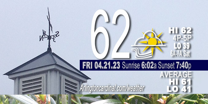
Friday Hi 62, mostly cloudy, winds SW to S to SW to W to NW, 6 to 15 to 6 MPH, G14 to 15 to 14 MPH
NWS CHGO | NWS HRLY | /NWSchicago | 🌡
ARLINGTON HEIGHTS WEATHER
▴ forecast7 (Arl. Hts.) | RADAR | WIDE RADAR
⏪ Hrly Data Table | Hrly Future Graph ⏩
IMPORTANT NOTE ON NWS DATA
⏪ Hrly Data Table | Hrly Future Graph ⏩
Hello mobile users! If you encounter a mobile “unfriendly” weather page, turn your phone sideways for a better view.
======================
Friday and Friday Evening …
No Weather Hazards expected …
Weather will trend breezy and cooler heading into the weekend, with readings around 15 degrees below average by Saturday.
DISCUSSION…
Temperature wise, while cooler today we`ll be closer to seasonal averages with highs around 60/low 60s and breezy southwest winds gusting 25 to 30 mph especially across the northwest half of the forecast area. Under the mid-level cold pool on Saturday however, highs may struggle into the mid-upper 40s by afternoon, or nearly 15 degrees below average. Blustery west winds gusting 20-25 mph Saturday will make for wind chills in the upper 30s and lower 40s.
UPDATE: A few very light sprinkles occurred Friday afternoon.
======================
O’HARE FORECAST …
Forecast Beginning Friday, Apr. 21, 2023
Friday: Partly sunny, with a high near 62. Southwest wind 10 to 15 mph, with gusts as high as 25 mph.
Friday Night: Partly cloudy, with a low around 39. West wind 5 to 15 mph.
Saturday: A 20 percent chance of showers. Partly sunny, with a high near 48. West wind 10 to 15 mph, with gusts as high as 20 mph.
Saturday Night: Mostly cloudy, with a low around 34. West northwest wind 10 to 15 mph, with gusts as high as 20 mph.
Sunday: Partly sunny, with a high near 48. West northwest wind 10 to 15 mph.
Sunday Night: Areas of frost after 4am. Otherwise, partly cloudy, with a low around 33.
Monday: Areas of frost before 8am. Otherwise, mostly sunny, with a high near 55.
Monday Night: Mostly cloudy, with a low around 38.
Tuesday: Partly sunny, with a high near 55.
Tuesday Night: Partly cloudy, with a low around 39.
Wednesday: Mostly sunny, with a high near 54.
Wednesday Night: Partly cloudy, with a low around 39.
Thursday: Partly sunny, with a high near 56.


CHICAGOWEATHERSTATION.COM

ChicagoWeatherStation.com I O’Hare Normal Temps/Precip I O’Hare Record Temps, Precip, Snow
WunderMap® with Temperature/Wind Data || Google: Arlington Heights Area Temps | US TEMPS
Midwest Cloud Cover with Arlington Heights Weather Forecast
ChicagoWeatherStation.com I O’Hare Normal Temps/Precip I O’Hare Record Temps, Precip, Snow
SUNLIGHT DATA FOR SECURITY, TRAFFIC SAFETY, AND SPORTS
SunCalc.net data with solar azimuth and trajectory, times for dawn, sunrise, solar noon, sunset, dusk …
NIGHT SKY THIS MONTH …
Backyard stargazers get a monthly guide to the northern hemisphere’s skywatching events with “Tonight’s Sky.” Check the night sky objects for this month and past months in the playlist from the Space Telescope Science Institute YouTube channel (Musical track The Far River written by Jonn Serrie, from the album And the Stars Go With You courtesy of New World Music Ltd).
Get updates from The Cardinal ALL NEWS FEEDS on Facebook. Just ‘LIKE’ the ‘Arlington Cardinal Page (become a fan of our page). The updates cover all posts and sub-category posts from The Cardinal — Arlingtoncardinal.com. You can also limit feeds to specific categories. See all of The Cardinal Facebook fan pages at Arlingtoncardinal.com/about/facebook …
Help fund The Cardinal Arlingtoncardinal.com/sponsor
/////////////>
Area Forecast Discussion
National Weather Service Chicago/Romeoville, IL
633 AM CDT Fri Apr 21 2023
.SHORT TERM… Issued at 319 AM CDT Fri Apr 21 2023
Through Saturday…
Weather will trend breezy and cooler heading into the weekend, with readings around 15 degrees below average by Saturday. Cold air aloft will likely support some diurnal showery precip on Saturday as well, with the potential for a rain/snow mix during the morning especially near the IL/WI border.
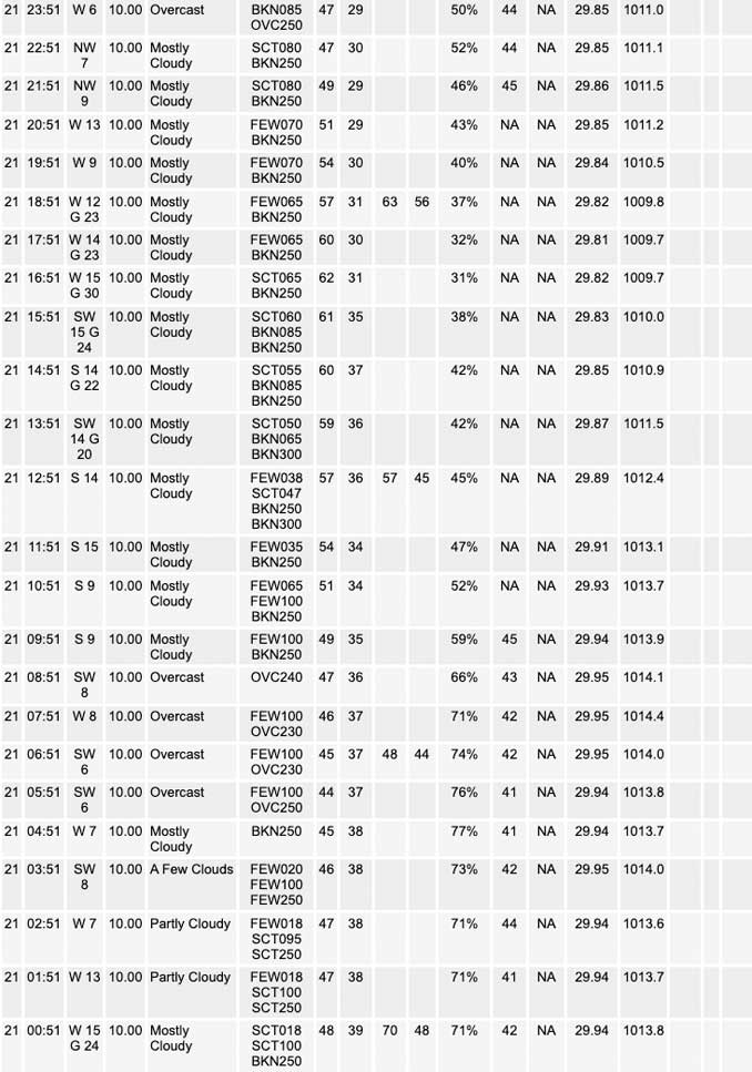
Early morning GOES vapor imagery depicted a deep upper trough across the central CONUS, with a closed low spinning over northwest MN. At the surface, an elongated west-east 1004 mb low stretched from northeast MN eastward across the south shore of Lake Superior. From there, an occluded front extended southeast into northern lower MI, with a cold front then trailing across western IN to the lower OH Valley. A few post-frontal showers lingered east of the I-57 corridor from east central IL into northern IN as of 3 am, though these should continue to drift east out of the forecast area through sunrise. Drier air will spread into the region from the west- southwest this morning, decreasing cloud cover across the northwest half of the forecast area while high clouds linger in the southeast.
A series of mid-level vorticity maxima will transit the southeastern periphery of the upper low to our north, which will maintain mid- level height falls and cooling of the mid-levels through the period. These cooling mid-level temps will in turn produce steep diurnal low level lapse rates by this afternoon which will support development of high-based stratocu. While a few stray sprinkles can`t be completely ruled out beneath this stratocu deck, relatively dry low levels do look to keep the cloud deck somewhat shallow and most areas should remain dry. Our far southeastern cwa may have a better potential for seeing some sprinkles or light showers late this afternoon into tonight however, as a mid-level short wave currently over the TX/OK panhandle region approaches the lower OH Valley later today and then lifts northeast across IN tonight with deeper mid- level moisture. The greatest precip chances area-wide appear to come on Saturday however, as a strong mid-level vort associated with the upper low wraps cyclonically east-southeastward across southern WI/IL/MI/IN. Colder mid-level temps aloft (around -16C at 700 mb, -27C at 500 mb!) will support deeper mixing and steep lapse rates from the surface to nearly 700 mb which should support a greater chance of convective showers during the day. Thermal profiles appear cold enough for some of this to come in a snow or rain/snow mix especially Saturday morning across far northern IL, especially close to the IL/WI border.
Temperature wise, while cooler today we`ll be closer to seasonal averages with highs around 60/low 60s and breezy southwest winds gusting 25 to 30 mph especially across the northwest half of the forecast area. Under the mid-level cold pool on Saturday however, highs may struggle into the mid-upper 40s by afternoon, or nearly 15 degrees below average. Blustery west winds gusting 20-25 mph Saturday will make for wind chills in the upper 30s and lower 40s.
Ratzer/NWS Chicago
