
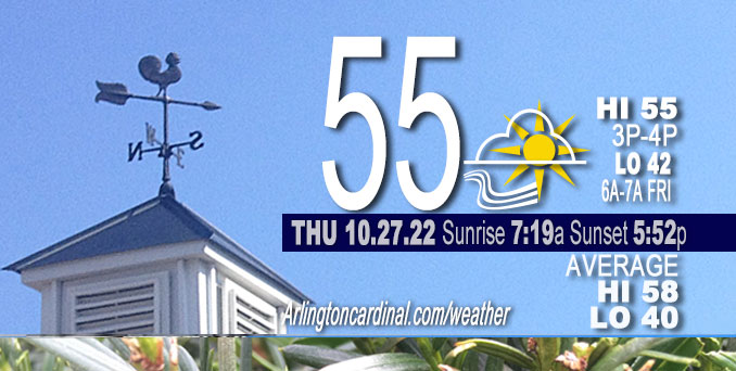
THURSDAY Hi 55°F, partly cloudy, slight increase in clouds toward evening, winds SE to E to ESE, 2 to 10 to 3MPH, G13 to 14 MPH after 7p
NWS CHGO | NWS HRLY | /NWSchicago | 🌡
ARLINGTON HEIGHTS WEATHER
▴ forecast7 (Arl. Hts.) | RADAR | WIDE RADAR
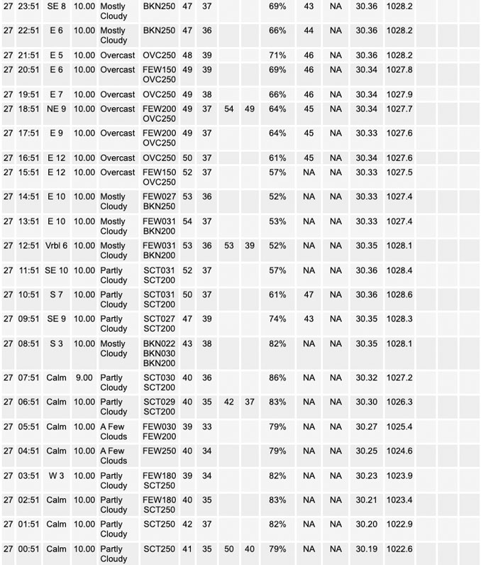
⏪ Hrly Data Table | Hrly Future Graph ⏩
IMPORTANT NOTE ON NWS DATA
⏪ Hrly Data Table | Hrly Future Graph ⏩
======================
No watches or warnings issued near O’Hare at 8:00 a.m. Thursday.
Updates at Arlingtoncardinal.com/NWSChicago
Today and Tonight.
No weather hazards expected…
A high pressure system of 1025 mb over Chicagoland is bringing quiet weather with light winds and near normal temperatures. A strong upper level low across the Four Corners region (southwestern corner of Colorado, southeastern corner of Utah, northeastern corner of Arizona, and northwestern corner of New Mexico) will fling some cirrus clouds over Chicagoland today. Fog is possible tonight near the Illinois Wisconsin state line. More sun and warmer tomorrow.
Hello mobile users! If you encounter mobile “unfriendly” weather page, turn your phone sideways for a better view.
======================
Quiescent weather remains in place through the end of the work week, largely thanks to high pressure of 1025 mb sprawled over the area this morning. Patches of radiational fog have developed in/near northwest Indiana, but otherwise all is tranquil early this morning. A digging strong upper level low across the Four Corners region and a couple of lead short waves over the Plains will fling some cirrus over the area today. There is a fairly decent signal on upper level model RH fields as well as those solutions that depict actual cloud cover that it will be mainly broken cirrus this afternoon. This should keep highs very similar to yesterday with 925 mb temperatures only having warmed 1C during the last 12-24 hours.
As the aforementioned upper low digs into west Texas by late tonight, the downstream response will be upper ridging building into the area from the southeast under a split jet stream flow regime. This should mean less cirrus by late tonight and especially Friday. If the cirrus deterioration happens quickly tonight, there could be a little bit of patchy ground fog again, mainly toward the Illinois/Wisconsin stateline. With more sun anticipated Friday and warming 925 mb temperatures to 9C to 10C, it should result in highs close to 60.
O’HARE FORECAST …
Forecast Beginning Thursday, Oct. 27, 2022
Thursday: Partly sunny, with a high near 55. Light east southeast wind becoming east 5 to 10 mph in the morning.
Thursday Night: Mostly cloudy, with a low around 42. East southeast wind 5 to 10 mph.
Friday: Sunny, with a high near 59. East southeast wind 5 to 10 mph.
Friday Night: Mostly clear, with a low around 40. East northeast wind around 5 mph becoming calm in the evening.
Saturday: Sunny, with a high near 63. Calm wind becoming east around 5 mph in the afternoon.
Saturday Night: Mostly cloudy, with a low around 46.
Sunday: A 40 percent chance of showers, mainly after 1pm. Cloudy, with a high near 61.
Sunday Night: A chance of showers before 1am. Mostly cloudy, with a low around 48.
Monday: Partly sunny, with a high near 62.
Monday Night: Mostly clear, with a low around 46.
Tuesday: Sunny, with a high near 65.
Tuesday Night: Mostly clear, with a low around 49.
Wednesday: Mostly sunny, with a high near 66.


CHICAGOWEATHERSTATION.COM

ChicagoWeatherStation.com I O’Hare Normal Temps/Precip I O’Hare Record Temps, Precip, Snow
LIVE RADAR | STORM TRACKS | UNISYS US IR SAT | UNISYS Midwest IR SAT | UNISYS More IR SAT
WunderMap® with Temperature/Wind Data || Google: Arlington Heights Area Temps | US TEMPS
Full Screen Motion Weather Radar (Wunderground.com)
Midwest Cloud Cover with Arlington Heights Weather Forecast
ChicagoWeatherStation.com I O’Hare Normal Temps/Precip I O’Hare Record Temps, Precip, Snow
SUNLIGHT DATA FOR SECURITY, TRAFFIC SAFETY, AND SPORTS
SunCalc.net data with solar azimuth and trajectory, times for dawn, sunrise, solar noon, sunset, dusk …
NIGHT SKY THIS MONTH …
Backyard stargazers get a monthly guide to the northern hemisphere’s skywatching events with “Tonight’s Sky.” Check the night sky objects for this month and past months in the playlist from the Space Telescope Science Institute YouTube channel (Musical track The Far River written by Jonn Serrie, from the album And the Stars Go With You courtesy of New World Music Ltd).
Get updates from The Cardinal ALL NEWS FEEDS on Facebook. Just ‘LIKE’ the ‘Arlington Cardinal Page (become a fan of our page). The updates cover all posts and sub-category posts from The Cardinal — Arlingtoncardinal.com. You can also limit feeds to specific categories. See all of The Cardinal Facebook fan pages at Arlingtoncardinal.com/about/facebook …
Help fund The Cardinal Arlingtoncardinal.com/sponsor
Area Forecast Discussion
National Weather Service Chicago/Romeoville, IL
612 AM CDT Thu Oct 27 2022
.SHORT TERM…
Issued at 139 AM CDT Thu Oct 27 2022
Through Friday…
Quiescent weather remains in place through the end of the work week, largely thanks to high pressure of 1025 mb sprawled over the area this morning. Patches of radiational fog have developed in/near northwest Indiana, but otherwise all is tranquil early this morning. A digging strong upper level low across the Four Corners region and a couple of lead short waves over the Plains will fling some cirrus over the area today. There is a fairly decent signal on upper level model RH fields as well as those solutions that depict actual cloud cover that it will be mainly broken cirrus this afternoon. This should keep highs very similar to yesterday with 925 mb temperatures only having warmed 1C during the last 12-24 hours.
As the aforementioned upper low digs into west Texas by late tonight, the downstream response will be upper ridging building into the area from the southeast under a split jet stream flow regime. This should mean less cirrus by late tonight and especially Friday. If the cirrus deterioration happens quickly tonight, there could be a little bit of patchy ground fog again, mainly toward the Illinois/Wisconsin stateline. With more sun anticipated Friday and warming 925 mb temperatures to 9C to 10C, it should result in highs close to 60.
MTF/NWS Chicago
