
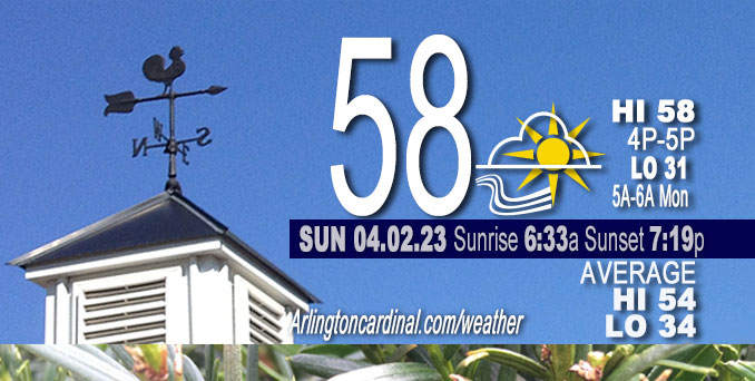
Sunday Hi 40, mostly cloudy to partly cloudy, winds W to NW, 18 to 26 to 5 MPH, G29 to 36 to 16 MPH, until 8p
NWS CHGO | NWS HRLY | /NWSchicago | 🌡
ARLINGTON HEIGHTS WEATHER
▴ forecast7 (Arl. Hts.) | RADAR | WIDE RADAR
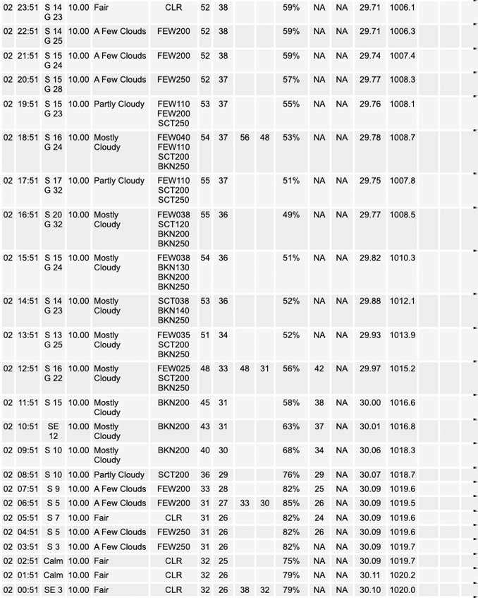
⏪ Hrly Data Table | Hrly Future Graph ⏩
IMPORTANT NOTE ON NWS DATA
⏪ Hrly Data Table | Hrly Future Graph ⏩
Hello mobile users! If you encounter a mobile “unfriendly” weather page, turn your phone sideways for a better view.
======================
Sunday and Sunday Evening …
No Weather Hazards expected …
Sunday high temperature 58 slightly above normal 54.
DISCUSSION…
High pressure will move east of the area this morning and the gradient will tighten today with southerly winds expected to gust into the 30-35 mph range which will continue into the early evening and then should steadily diminish as a weak cool front moves into the area Sunday night. This frontal boundary will move into central Illinois and central Indiana Monday with northeasterly winds developing across the area.
======================
O’HARE FORECAST …
Forecast Beginning Sunday, Apr. 02, 2023
Sunday: Partly sunny, with a high near 58. Breezy, with a south wind around 20 mph, with gusts as high as 30 mph.
Sunday Night: Partly cloudy, with a low around 41. Breezy, with a south wind 15 to 20 mph becoming west 5 to 10 mph after midnight. Winds could gust as high as 30 mph.
Monday: A 50 percent chance of showers, mainly after 1pm. Mostly cloudy, with a high near 56. Southwest wind 5 to 10 mph becoming east northeast in the afternoon.
Monday Night: Showers and possibly a thunderstorm before 1am, then a chance of showers and thunderstorms between 1am and 4am, then a chance of showers after 4am. Low around 42. East northeast wind 10 to 15 mph, with gusts as high as 25 mph. Chance of precipitation is 80%.
Tuesday: A chance of showers before 10am, then a chance of showers and thunderstorms between 10am and 1pm, then showers likely and possibly a thunderstorm after 1pm. Cloudy, with a high near 63. East northeast wind 10 to 15 mph becoming southeast in the afternoon. Winds could gust as high as 25 mph. Chance of precipitation is 60%.
Tuesday Night: Showers and possibly a thunderstorm. Low around 55. Breezy. Chance of precipitation is 90%.
Wednesday: A 40 percent chance of showers, mainly before 1pm. Mostly sunny, with a high near 64. Breezy.
Wednesday Night: Mostly clear, with a low around 31. Breezy.
Thursday: Mostly sunny, with a high near 46. Breezy.
Thursday Night: Mostly clear, with a low around 30. Breezy.
Friday: Mostly sunny, with a high near 51.
Friday Night: Partly cloudy, with a low around 37.
Saturday: Mostly sunny, with a high near 56.


CHICAGOWEATHERSTATION.COM

ChicagoWeatherStation.com I O’Hare Normal Temps/Precip I O’Hare Record Temps, Precip, Snow
LIVE RADAR | STORM TRACKS | UNISYS US IR SAT | UNISYS Midwest IR SAT | UNISYS More IR SAT
WunderMap® with Temperature/Wind Data || Google: Arlington Heights Area Temps | US TEMPS
Full Screen Motion Weather Radar (Wunderground.com)
Midwest Cloud Cover with Arlington Heights Weather Forecast
ChicagoWeatherStation.com I O’Hare Normal Temps/Precip I O’Hare Record Temps, Precip, Snow
SUNLIGHT DATA FOR SECURITY, TRAFFIC SAFETY, AND SPORTS
SunCalc.net data with solar azimuth and trajectory, times for dawn, sunrise, solar noon, sunset, dusk …
NIGHT SKY THIS MONTH …
Backyard stargazers get a monthly guide to the northern hemisphere’s skywatching events with “Tonight’s Sky.” Check the night sky objects for this month and past months in the playlist from the Space Telescope Science Institute YouTube channel (Musical track The Far River written by Jonn Serrie, from the album And the Stars Go With You courtesy of New World Music Ltd).
Get updates from The Cardinal ALL NEWS FEEDS on Facebook. Just ‘LIKE’ the ‘Arlington Cardinal Page (become a fan of our page). The updates cover all posts and sub-category posts from The Cardinal — Arlingtoncardinal.com. You can also limit feeds to specific categories. See all of The Cardinal Facebook fan pages at Arlingtoncardinal.com/about/facebook …
Help fund The Cardinal Arlingtoncardinal.com/sponsor
/////////////>
Area Forecast Discussion
National Weather Service Chicago/Romeoville, IL
610 AM CDT Sun Apr 2 2023
.SHORT TERM… Issued at 218 AM CDT Sun Apr 2 2023
Through Monday…
Only forecast concern are winds this afternoon/evening.
High pressure will move east of the area this morning and the gradient will tighten today with southerly winds expected to gust into the 30-35 mph range which will continue into the early evening and then should steadily diminish as a weak cool front moves into the area tonight. This frontal boundary will move into central IL and central IN Monday with northeasterly winds developing across the area.
There will be increasing chances for showers on Monday with the best chances likely in the afternoon but this activity is likely to remain scattered and its possible that much of the morning will remain dry but held onto low chance pops for now.
Highs today are likely to reach the upper 50s/lower 60s and with mainly sunny skies, its possible high temps end up a little warmer. Highs on Monday are a bit more uncertain. Northeasterly winds will keep temps closer to the lake cooler. If mostly cloudy skies materialize, temps may only reach mid/upper 50s but if enough sun breaks through the clouds, lower/mid 60s will be possible further inland and also south of the frontal boundary, should that still be in the southern cwa. cms/NWS Chicago
