
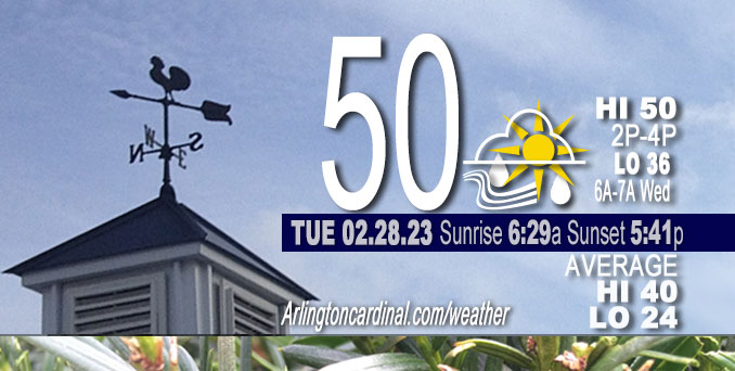
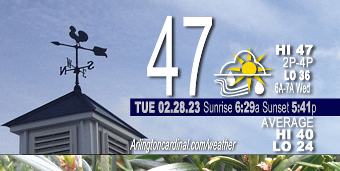
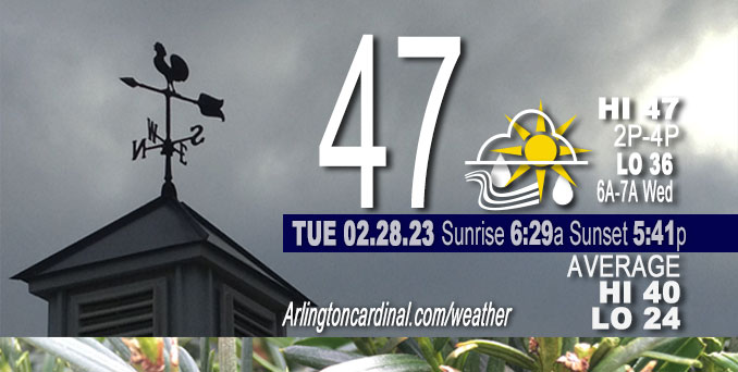
Tuesday Hi 50, rain after 8p, mostly cloudy to partly sunny, winds NW to NE to E to ESE, 9 to 2 to 10 MPH, G13 to 16 to 14, 3a Wed.
NWS CHGO | NWS HRLY | /NWSchicago | 🌡
ARLINGTON HEIGHTS WEATHER
▴ forecast7 (Arl. Hts.) | RADAR | WIDE RADAR
⏪ Hrly Data Table | Hrly Future Graph ⏩
IMPORTANT NOTE ON NWS DATA
⏪ Hrly Data Table | Hrly Future Graph ⏩
======================
Tuesday and Tuesday Evening …
No Weather Hazards expected …
Rain totaling 0.10 inch forecast Tuesday between 8:00 p.m. and 3:00 a.m.
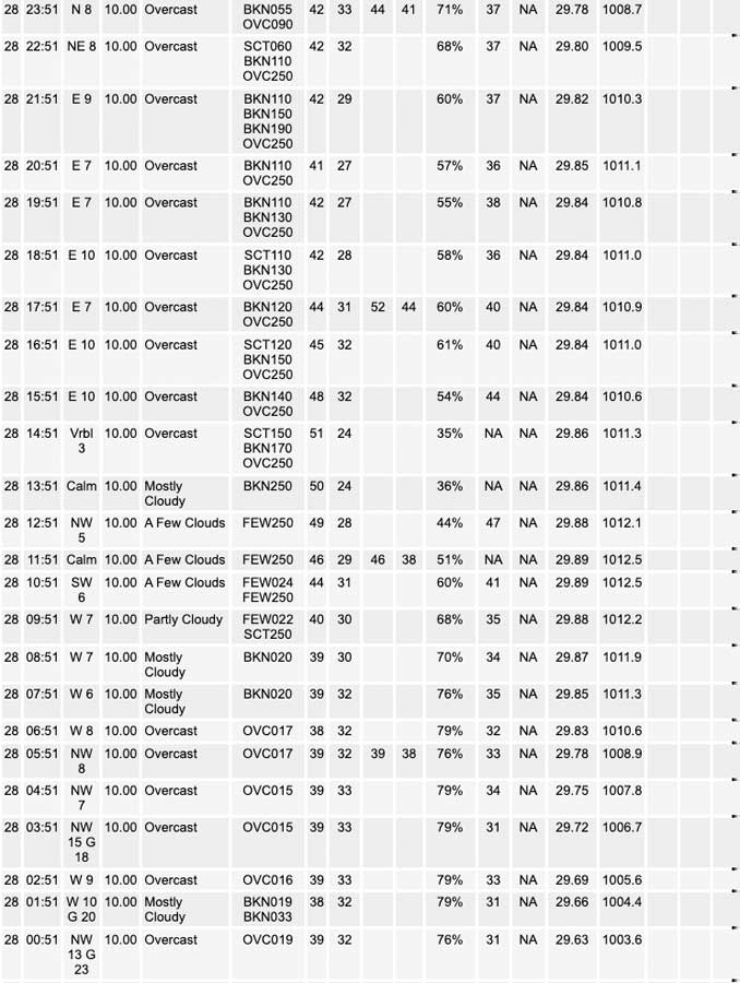
Total rainfall reported at O’Hare International Airport for Monday, February 27, 2023 was 1.01 inch.
DISCUSSION…
The main forecast for Tuesday concerns clouds and clearing timing with subsequent impacts on the high temperature forecast. The current stratus deck has a fairly well-defined back edge which is tracking along well at a steady state and without significant isentropic ascent/warm advection along the western flanks. Clearing will eventually Chicagoland later Tuesday morning and afternoon, but temperatures will hold generally in the mid and upper 40s as a result lingering cloud cover. Weak gradient flow and clearing skies should allow a modest lake breeze to develop this afternoon, and this will drive some late-day lake cooling across northeast Illinois and northwest Indiana.
======================
O’HARE FORECAST …
Forecast Beginning Tuesday, Feb. 28, 2023
Tuesday: Partly sunny, with a high near 47. Northwest wind 5 to 10 mph becoming light and variable.
Tuesday Night: Rain, mainly before 3am. Low around 36. East wind 5 to 10 mph, with gusts as high as 15 mph. Chance of precipitation is 80%. New precipitation amounts of less than a tenth of an inch possible.
Wednesday: Partly sunny, with a high near 55. South southeast wind 5 to 15 mph becoming west northwest in the afternoon. Winds could gust as high as 25 mph.
Wednesday Night: Increasing clouds, with a low around 34. West northwest wind around 10 mph becoming north northeast after midnight. Winds could gust as high as 20 mph.
Thursday: Mostly cloudy, with a high near 39. Northeast wind 10 to 15 mph, with gusts as high as 20 mph.
Thursday Night: A slight chance of rain before midnight, then a chance of rain and snow. Mostly cloudy, with a low around 33. Breezy. Chance of precipitation is 40%.
Friday: Rain and snow. High near 34. Breezy. Chance of precipitation is 80%.
Friday Night: A chance of snow before midnight. Mostly cloudy, with a low around 24. Blustery.
Saturday: Partly sunny, with a high near 39.
Saturday Night: Mostly cloudy, with a low around 26.
Sunday: Mostly sunny, with a high near 42.
Sunday Night: Partly cloudy, with a low around 31.
Monday: Partly sunny, with a high near 48.


CHICAGOWEATHERSTATION.COM

ChicagoWeatherStation.com I O’Hare Normal Temps/Precip I O’Hare Record Temps, Precip, Snow
LIVE RADAR | STORM TRACKS | UNISYS US IR SAT | UNISYS Midwest IR SAT | UNISYS More IR SAT
WunderMap® with Temperature/Wind Data || Google: Arlington Heights Area Temps | US TEMPS
Full Screen Motion Weather Radar (Wunderground.com)
Midwest Cloud Cover with Arlington Heights Weather Forecast
ChicagoWeatherStation.com I O’Hare Normal Temps/Precip I O’Hare Record Temps, Precip, Snow
SUNLIGHT DATA FOR SECURITY, TRAFFIC SAFETY, AND SPORTS
SunCalc.net data with solar azimuth and trajectory, times for dawn, sunrise, solar noon, sunset, dusk …
NIGHT SKY THIS MONTH …
Backyard stargazers get a monthly guide to the northern hemisphere’s skywatching events with “Tonight’s Sky.” Check the night sky objects for this month and past months in the playlist from the Space Telescope Science Institute YouTube channel (Musical track The Far River written by Jonn Serrie, from the album And the Stars Go With You courtesy of New World Music Ltd).
Get updates from The Cardinal ALL NEWS FEEDS on Facebook. Just ‘LIKE’ the ‘Arlington Cardinal Page (become a fan of our page). The updates cover all posts and sub-category posts from The Cardinal — Arlingtoncardinal.com. You can also limit feeds to specific categories. See all of The Cardinal Facebook fan pages at Arlingtoncardinal.com/about/facebook …
Help fund The Cardinal Arlingtoncardinal.com/sponsor
Area Forecast Discussion
National Weather Service Chicago/Romeoville, IL
538 AM CST Tue Feb 28 2023
.SHORT TERM… Issued at 235 AM CST Tue Feb 28 2023
Through Wednesday…
The main forecast questions today revolve around clouds and clearing trends with subsequent impacts on the high temperature forecast. The current stratus deck has a fairly well-defined back edge which is tracking along well at a steady state and with not a whole lot of isentropic ascent/warm advection along the western flanks, it does look like this clearing will eventually make its way into our area later this morning and afternoon. Have maintained afternoon temperatures generally in the mid and upper 40s as a result. Weak gradient flow and clearing skies should allow a modest lake breeze to develop this afternoon, and this will drive some late-day lake cooling across NE IL and NW IN.
Tonight: a lower amplitude but broad wave will approach the region yielding an increase in rather intense warm advection through the evening hours. In many ways, this looks like a similar set-up to last Friday`s, just with a bit more moisture and warmer thermal profiles. Arcing bands of mid-level f-gen will drift across northern Illinois, and with a reservoir instability present aloft, it`s looking like these will have no issue in quickly saturating the column yielding a rapid increase in fairly widespread showers. Have boosted PoPs to show a brief period of categoricals just after midnight across NE/N IL. Surface wetbulb temperatures are forecast to be just above freezing, with the better chances for sub-freezing temps well north of the WI state line. Held onto a brief mention of a rain/snow mix across our far north as precipitation begins. Given the thermal profiles as the column is initially saturating in the presence of instability, would not be surprised if a few ice pellets/sleet were mixed in as well, but the above-freezing airmass means that no impacts are anticipated.
Activity will quickly scoot east and north of the region through the late overnight hours. Some signal that things could come to end as a little non-freezing drizzle and maybe a little fog/mist. Have not incorporated this into the forecast given uncertainties, but best chances would be north of I-80. There are some questions regarding cloud and temperature trends into Wednesday, with the NAM holding onto much of the incipient low-level moisture through the day. Given pretty good agreement that westerly momentum will overspread the region within a zone of modest cold advection, thinking is that we`ll manage to dislodge any cloud cover pretty readily and have continued to side with the warmer guidance for highs Wednesday afternoon ahead of the next cold front which will eventually drop into the region through the evening.
Carlaw/NWS Chicago
