
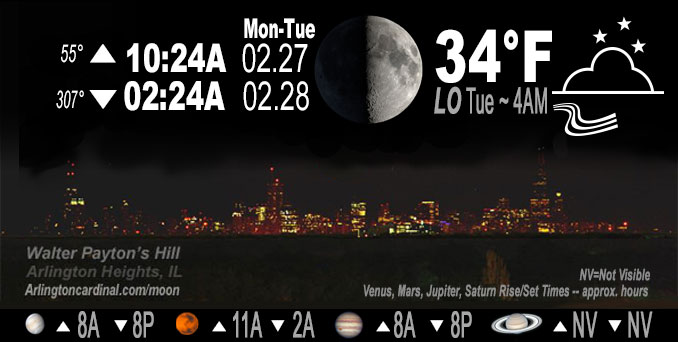
🌓 🌕 🌗 🌑 1st Quarter Moon, sky cover overnight Mon. to Tue. 83% to 70%, winds WNW, 14 to 21 to 9 MPH, G33 to 38 to 11 MPH, end 10a Tue, Low 34, 4a to 7a
NWS CHGO | NWS HRLY | /NWSchicago | 🌡
ARLINGTON HEIGHTS WEATHER
▴ forecast7 (Arl. Hts.) | RADAR | WIDE RADAR
IMPORTANT NOTE ON NWS DATA
======================
NIGHT FORECASTS …
NOTE: Keep in mind lunar rise and set times don’t always correspond with night weather and early morning lows because on some days during the month the moon is visible in the sky predominantly during the daytime hours.
Overnight Monday/Tuesday …
Weather Hazards expected
Limited Non Thunderstorm Wind Risk.
DISCUSSION…
West winds are expected to gust to 40 mph Monday evening.
Hello mobile users! If you encounter a mobile “unfriendly” weather page, turn your phone sideways for a better view.
======================
O’HARE FORECAST …
Forecast Beginning Monday Night, Feb. 27, 2023 …
Monday Night: Mostly cloudy, with a low around 34. Breezy, with a west northwest wind 10 to 20 mph, with gusts as high as 40 mph.
Tuesday: Partly sunny, with a high near 48. West northwest wind 5 to 10 mph becoming east southeast in the afternoon. Winds could gust as high as 15 mph.
Tuesday Night: Rain likely, mainly after midnight. Mostly cloudy, with a low around 37. East wind 5 to 15 mph becoming south after midnight. Winds could gust as high as 20 mph. Chance of precipitation is 60%. New precipitation amounts of less than a tenth of an inch possible.
Wednesday: Mostly cloudy, with a high near 58. South wind around 10 mph becoming north in the afternoon. Winds could gust as high as 15 mph.
Wednesday Night: Mostly cloudy, with a low around 33. North wind 10 to 15 mph, with gusts as high as 25 mph.
Thursday: Mostly cloudy, with a high near 38.
Thursday Night: A 30 percent chance of snow after midnight. Mostly cloudy, with a low around 31.
Friday: Snow likely, mainly after noon. Mostly cloudy, with a high near 36. Breezy.
Friday Night: Mostly cloudy, with a low around 25. Blustery.
Saturday: Mostly sunny, with a high near 41.
Saturday Night: Mostly cloudy, with a low around 28.
Sunday: Mostly sunny, with a high near 46.
Sunday Night: Partly cloudy, with a low around 33.
Monday: Partly sunny, with a high near 50.
O’Hare forecast archive and hourly weather observations archive are available HERE on the CARDINAL NEWS Magazine.
Arlingtoncardinal.com/moonphases
Arlingtoncardinal.com/nightsky
NIGHT SKY THIS MONTH …
Check the night sky objects for this month and past months in the playlist from the Space Telescope Science Institute YouTube channel Backyard stargazers get a monthly guide to the northern hemisphere’s skywatching events with “Tonight’s Sky” (Musical track The Far River written by Jonn Serrie, from the album And the Stars Go With You courtesy of New World Music Ltd. Musical track The Far River written by Jonn Serrie, from the album And the Stars Go With You courtesy of New World Music Ltd).
Telephoto lens, ISO 100, f/11, Shutter Speed 1/100 to 1/125 for the Moon.
Get updates from The Cardinal ALL NEWS FEEDS on Facebook. Just ‘LIKE’ the ‘Arlington Cardinal Page (become a fan of our page). The updates cover all posts and sub-category posts from The Cardinal — Arlingtoncardinal.com. You can also limit feeds to specific categories. See all of The Cardinal Facebook fan pages at Arlingtoncardinal.com/about/facebook …
Help fund The Cardinal Arlingtoncardinal.com/sponsor
Telephoto lens, ISO 1600, f/11, Shutter Speed 2.5″ for the skyline. The skyline exposure was toned down, and brightness and contrast was adjusted in Photoshop.
Area Forecast Discussion
National Weather Service Chicago/Romeoville, IL
1137 PM CST Mon Feb 27 2023
.SHORT TERM… Issued at 242 PM CST Mon Feb 27 2023
Through Tuesday night…
Forecast concerns for the short term period… *Gusty westerly winds continue through this evening with gusts of 35 to 40 mph
*Another quick hit of precipitation Tuesday night
The strong 986 mb surface low is currently moving across northern Illinois as of this writing and is expected to move east of the area this evening. As the low moves out of the area the lingering light showers currently being observed over portions of northwestern Indiana will also move out of the area and allow dry conditions to prevail through Tuesday afternoon. However, the tight pressure gradient (13 to 14 mb rises per 6 hours) will allow the gusty winds to remain through this evening with gusts expected to peak in the 35 to 40 mph range in the wake of the cold front that is currently moving through the area. Winds are expected to gradually ease after midnight as a surface high begins to move into the region.
Skies are expected to remain mostly to partly cloudy through the day on Tuesday as lingering low-level moisture becomes trapped under the subsidence inversion. Despite the cloud cover, temperatures do look to warm into the mid to upper 40s Tuesday afternoon as southeast flow returns and starts to advect in warmer air ahead of a shortwave disturbance that will swing through the region Tuesday night. While guidance continues to track this shortwave into southern Wisconsin, sufficient moisture is expected to return across portions of northern Illinois which will allow for a quick hit of precipitation. Thankfully, forecast soundings show that temperatures, both aloft and at the surface, are expected to remain above freezing which will keep the precipitation in the form of rain.
Yack/NWS Chicago
Area Forecast Discussion
National Weather Service Chicago/Romeoville, IL
235 AM CST Tue Feb 28 2023
.SHORT TERM… Issued at 235 AM CST Tue Feb 28 2023
Through Wednesday…
The main forecast questions today revolve around clouds and clearing trends with subsequent impacts on the high temperature forecast. The current stratus deck has a fairly well-defined back edge which is tracking along well at a steady state and with not a whole lot of isentropic ascent/warm advection along the western flanks, it does look like this clearing will eventually make its way into our area later this morning and afternoon. Have maintained afternoon temperatures generally in the mid and upper 40s as a result. Weak gradient flow and clearing skies should allow a modest lake breeze to develop this afternoon, and this will drive some late-day lake cooling across NE IL and NW IN.
Tonight: a lower amplitude but broad wave will approach the region yielding an increase in rather intense warm advection through the evening hours. In many ways, this looks like a similar set-up to last Friday`s, just with a bit more moisture and warmer thermal profiles. Arcing bands of mid-level f-gen will drift across northern Illinois, and with a reservoir instability present aloft, it`s looking like these will have no issue in quickly saturating the column yielding a rapid increase in fairly widespread showers. Have boosted PoPs to show a brief period of categoricals just after midnight across NE/N IL. Surface wetbulb temperatures are forecast to be just above freezing, with the better chances for sub-freezing temps well north of the WI state line. Held onto a brief mention of a rain/snow mix across our far north as precipitation begins. Given the thermal profiles as the column is initially saturating in the presence of instability, would not be surprised if a few ice pellets/sleet were mixed in as well, but the above-freezing airmass means that no impacts are anticipated.
Activity will quickly scoot east and north of the region through the late overnight hours. Some signal that things could come to end as a little non-freezing drizzle and maybe a little fog/mist. Have not incorporated this into the forecast given uncertainties, but best chances would be north of I-80. There are some questions regarding cloud and temperature trends into Wednesday, with the NAM holding onto much of the incipient low-level moisture through the day. Given pretty good agreement that westerly momentum will overspread the region within a zone of modest cold advection, thinking is that we`ll manage to dislodge any cloud cover pretty readily and have continued to side with the warmer guidance for highs Wednesday afternoon ahead of the next cold front which will eventually drop into the region through the evening.
Carlaw/NWS Chicago
