
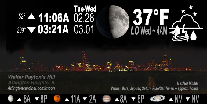
🌔 🌕 🌗 🌑 Waxing Gibbous Moon, rain 11p to 3a, sky cover overnight Tue. to Wed. 86% to 94% to 73%, winds E to ENE to SE, 8 to 10 to 5 MPH, G15 to 18 to 11 MPH, end 5a Wed, Low 37, 4a to 6a
NWS CHGO | NWS HRLY | /NWSchicago | 🌡
ARLINGTON HEIGHTS WEATHER
▴ forecast7 (Arl. Hts.) | RADAR | WIDE RADAR
IMPORTANT NOTE ON NWS DATA
======================
NIGHT FORECASTS …
NOTE: Keep in mind lunar rise and set times don’t always correspond with night weather and early morning lows because on some days during the month the moon is visible in the sky predominantly during the daytime hours.
Overnight Tuesday/Wednesday …
Weather Hazards expected
Limited Thunderstorm Risk.
DISCUSSION…
A few lightning strikes are possible late this evening mainly along and north of Interstate 80.
Venus and Jupiter in conjunction. Both planets set about 8:15 p.m. Venus sets at 8:12 p.m. and Jupiter sets at 8:17 p.m.
Hello mobile users! If you encounter a mobile “unfriendly” weather page, turn your phone sideways for a better view.
======================
O’HARE FORECAST …
Forecast Beginning Tuesday Night, Feb. 28, 2023 …
Tonight: Rain and thunderstorms before 4am, then a slight chance of rain between 4am and 5am. Low around 37. East wind 5 to 10 mph, with gusts as high as 20 mph. Chance of precipitation is 80%. New rainfall amounts between a tenth and quarter of an inch, except higher amounts possible in thunderstorms.
Wednesday: Partly sunny, with a high near 55. East wind 5 to 10 mph becoming west in the afternoon. Winds could gust as high as 15 mph.
Wednesday Night: Mostly cloudy, with a low around 35. West wind 5 to 10 mph becoming north after midnight. Winds could gust as high as 15 mph.
Thursday: Mostly cloudy, with a high near 39. Northeast wind 10 to 15 mph, with gusts as high as 20 mph.
Thursday Night: A chance of rain and snow, mainly after midnight. Mostly cloudy, with a low around 33. Breezy, with an east northeast wind 15 to 20 mph, with gusts as high as 40 mph. Chance of precipitation is 40%.
Friday: Rain and snow. High near 37. Windy. Chance of precipitation is 80%.
Friday Night: A chance of rain and snow before midnight. Mostly cloudy, with a low around 27. Blustery. Chance of precipitation is 30%.
Saturday: Partly sunny, with a high near 38.
Saturday Night: Mostly cloudy, with a low around 27.
Sunday: Mostly sunny, with a high near 42.
Sunday Night: Partly cloudy, with a low around 31.
Monday: Partly sunny, with a high near 46.
Monday Night: Mostly cloudy, with a low around 35.
Tuesday: Partly sunny, with a high near 43.
O’Hare forecast archive and hourly weather observations archive are available HERE on the CARDINAL NEWS Magazine.
Arlingtoncardinal.com/moonphases
Arlingtoncardinal.com/nightsky
NIGHT SKY THIS MONTH …
Check the night sky objects for this month and past months in the playlist from the Space Telescope Science Institute YouTube channel Backyard stargazers get a monthly guide to the northern hemisphere’s skywatching events with “Tonight’s Sky” (Musical track The Far River written by Jonn Serrie, from the album And the Stars Go With You courtesy of New World Music Ltd. Musical track The Far River written by Jonn Serrie, from the album And the Stars Go With You courtesy of New World Music Ltd).
Telephoto lens, ISO 100, f/11, Shutter Speed 1/100 to 1/125 for the Moon.
Get updates from The Cardinal ALL NEWS FEEDS on Facebook. Just ‘LIKE’ the ‘Arlington Cardinal Page (become a fan of our page). The updates cover all posts and sub-category posts from The Cardinal — Arlingtoncardinal.com. You can also limit feeds to specific categories. See all of The Cardinal Facebook fan pages at Arlingtoncardinal.com/about/facebook …
Help fund The Cardinal Arlingtoncardinal.com/sponsor
Telephoto lens, ISO 1600, f/11, Shutter Speed 2.5″ for the skyline. The skyline exposure was toned down, and brightness and contrast was adjusted in Photoshop.
Area Forecast Discussion
National Weather Service Chicago/Romeoville, IL
909 PM CST Tue Feb 28 2023
.UPDATE… Issued at 909 PM CST Tue Feb 28 2023
The rain is still on track for overnight for areas along/north of Interstate-80. Unsurprisingly, given the steep mid-level lapse rates in place, the initial showers that have developed over the Quad Cities have a convective look to them and in fact, a few have had cloud-to-ground lightning strikes. Because of this, opted to add a slight chance thunder through 1-2am as showers expand in coverage over the area. Just cannot fully rule out a lightning strike or two. Wouldn`t be surprised if locations directly beneath a more robust shower could even see a brief bout of sleet/graupel mixed in there. Most areas will remain lightning free, however.
Otherwise the forecast remains on track with precipitation moving out of the area by daybreak with a warm start to the first day of March and meteorological spring expected!
Petr
&&
.SHORT TERM… Issued at 228 PM CST Tue Feb 28 2023
Through Wednesday night…
The surface high that was centered across northern Illinois this morning has moved east of the area as an upper-level shortwave continues to move across the central Plains towards us. Mid-level clouds will continue to fill across the region this afternoon as better moisture returns ahead of the shortwave which will lead to the development of showers late this evening as the lower levels saturate. Forecast soundings continue to show that temperatures aloft would be increasing through the night with surface temperatures expected to remain above freezing which will keep the showers mainly in the form of rain. However, some hi-res guidance is indicating that an isothermal layer aloft would be present as the showers begin to enter far northern Illinois which may allow for some snow grains and/or ice pellets to mix in briefly. While confidence in any of these frozen hydrometeors reaching the ground remains low, I did maintain a rain-snow mention for areas right along the Illinois-Wisconsin line where this potential looks to be maximized. Regardless, no frozen precipitation accumulations are expected as surface temperatures should remain above freezing.
The rain showers are expected to taper off during the predawn hours Wednesday morning as drier air filters in aloft, but lingering moisture in the low-levels may allow for some mist and/or light drizzle to persist through daybreak. At this time I have forgone a formal mention of any drizzle in the forecast as soundings show that the moisture depth to be rather shallow and shrinking quickly with time.
Otherwise, dry conditions will persist through Wednesday night with partly to mostly cloudy skies. Despite the cloud cover, temperatures are expected to climb into the the mid to upper 50s Wednesday afternoon thanks to south-southwesterly winds that will advect warmer air into the region. However, a weak cold front will slide through the area Wednesday evening dropping temperatures into the low to mid 30s by Thursday morning.
Yack/NWS Chicago
