
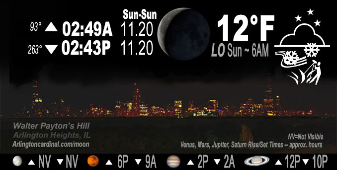
🌘 🌑 🌗 🌕 Waning Crescent Moon, sky cover overnight Sat. to Sun. 72% to 12% to 25%, winds WNW to W, 20 to 13 MPH, G32 to 18 MPH, Low 12, 6a to 7a
NWS CHGO | NWS HRLY | /NWSchicago | 🌡
ARLINGTON HEIGHTS WEATHER
▴ forecast7 (Arl. Hts.) | RADAR | WIDE RADAR
IMPORTANT NOTE ON NWS DATA
======================
Saturday Night …
Weather hazards expected…
This Hazardous Weather Outlook is for portions of North Central Illinois…Northeast Illinois and Northwest Indiana.
Limited Snow Risk for northeast Porter County.
Limited Non Thunderstorm Wind Risk.
Limited Excessive Cold Risk.
DISCUSSION…
Wind-whipped lake effect snow showers will accumulate up to an inch or so this evening in far northeast Porter County. The light snow accumulation on untreated roads and periods of low visibility may cause hazardous travel.
Westerly winds will gust up to 35 to 40 mph through this evening, strongest near the lake in far northeast Porter County where sporadic gusts up to 45 mph are possible.
Wind chills late tonight of zero to 10 below zero are forecast, lowest near and west of the Fox River Valley. Arlington Heights windchill 0°F at 2:00 a.m., then -1°F until 5:00 a.m. and -3°F at 6:00 a.m. Warmup Sunday afternoon to 32°F with a windchill around 21°F from 3:00 p.m. to 5:00 p.m.
Hello mobile users! If you encounter mobile “unfriendly” weather page, turn your phone sideways for a better view.
======================
O’HARE FORECAST …
Forecast Beginning Saturday Night, Nov. 19, 2022
Saturday Night: Occasional light snow with isolated snow showers before 8pm, then occasional light snow between 8pm and 9pm. Low around 12. Wind chill values as low as -1. Blustery, with a west northwest wind 15 to 20 mph, with gusts as high as 35 mph. Chance of precipitation is 80%. Little or no snow accumulation expected.
Sunday: Mostly sunny, with a high near 32. Wind chill values as low as -3. South southwest wind 10 to 15 mph, with gusts as high as 25 mph.
Sunday Night: Increasing clouds, with a low around 30. Breezy, with a southwest wind 15 to 20 mph, with gusts as high as 35 mph.
Monday: Partly sunny, then gradually becoming sunny, with a high near 43. West wind 5 to 15 mph, with gusts as high as 30 mph.
Monday Night: Mostly clear, with a low around 26. West northwest wind around 5 mph becoming south southwest after midnight.
Tuesday: Sunny, with a high near 46.
Tuesday Night: Mostly clear, with a low around 30.
Wednesday: Mostly sunny, with a high near 49.
Wednesday Night: Mostly cloudy, with a low around 36.
Thanksgiving Day: A chance of rain after noon. Mostly cloudy, with a high near 48.
Thursday Night: A chance of rain and snow. Mostly cloudy, with a low around 35.
Friday: A chance of rain and snow. Mostly cloudy, with a high near 41.
Friday Night: Mostly cloudy, with a low around 30.
Saturday: Partly sunny, with a high near 41.
O’Hare forecast archive and hourly weather observations archive are available HERE on the CARDINAL NEWS Magazine.
Arlingtoncardinal.com/moonphases
Arlingtoncardinal.com/nightsky
NIGHT SKY THIS MONTH …
Check the night sky objects for this month and past months in the playlist from the Space Telescope Science Institute YouTube channel Backyard stargazers get a monthly guide to the northern hemisphere’s skywatching events with “Tonight’s Sky” (Musical track The Far River written by Jonn Serrie, from the album And the Stars Go With You courtesy of New World Music Ltd. Musical track The Far River written by Jonn Serrie, from the album And the Stars Go With You courtesy of New World Music Ltd).
Telephoto lens, ISO 100, f/11, Shutter Speed 1/100 to 1/125 for the Moon.
Get updates from The Cardinal ALL NEWS FEEDS on Facebook. Just ‘LIKE’ the ‘Arlington Cardinal Page (become a fan of our page). The updates cover all posts and sub-category posts from The Cardinal — Arlingtoncardinal.com. You can also limit feeds to specific categories. See all of The Cardinal Facebook fan pages at Arlingtoncardinal.com/about/facebook …
Help fund The Cardinal Arlingtoncardinal.com/sponsor
Telephoto lens, ISO 1600, f/11, Shutter Speed 2.5″ for the skyline. The skyline exposure was toned down, and brightness and contrast was adjusted in Photoshop.
Area Forecast Discussion
National Weather Service Chicago/Romeoville, IL
516 PM CST Sat Nov 19 2022
.SHORT TERM… Issued at 300 PM CST Sat Nov 19 2022
Through Sunday night…
Key Messages:
* A period of heavier lake effect snow and wind into northeast Porter County through this evening
* Bitterly cold tonight into early Sunday with lowest wind chills of 0 to -10F
* Gusty winds Sunday PM and especially Sunday night, when gusts up to 35-40 mph will be possible
The mid-winter pattern of daily flurries and snow showers has again not disappointed today, with scattered bursts of heavy snow in the most robust snow showers over northeast Illinois and northwest Indiana. Given this behavior, we probably weren`t far off moisture depth wise from higher end type snow squalls. The threat for additional brief heavier snow bursts will be winding down and focus closer to the lake through about 5 PM CST.
Concern then shifts to a period of very favorable lake effect parameters for northeastern Porter County this evening. The extreme lake induced instability with such a cold air mass (-17C at 850 mb at KMPX at 12z) overhead will compensate for the non- classic 290-300 deg wind direction for multi-cellular LES into northeast Porter and particularly LaPorte Counties.
Well below freezing air temperatures, winds still gusting up to 35 mph or so and falling snow suggests some hazardous travel conditions could develop. Explicitly forecasting 1-1.5″ accumulation for the area of concern. Contemplated issuing a short-fused Winter Weather Advisory for Porter County, but opted to hold off with some uncertainty on magnitude of any impacts and higher confidence in them for northern LaPorte County. Planning to issue a SPS and hitting the the threat in one of the afternoon Weather Story graphics. Will continue to monitor trends over the next few hours.
Otherwise, the main story for the rest of the area will be the mid-winter cold. Very low dew points in the dry Arctic air mass supports some mid-high (positive) single digit lows, especially in favored cold spots of northern Illinois. The surface high passing well to the south will mean some wind (but certainly not like what`s occurring as of this writing) through the night, yielding minimum wind chills early Sunday of 0 to -10F.
The PV anomaly responsible for the bitterly cold weather will quickly kick out on Sunday, with southwesterly warm advection in its wake. May see some mid clouds through early afternoon followed by clearing. Southwesterly winds will increase in response to pressure falls from an approaching frontal trough, with afternoon gusts up to 25-30 mph. Warm advection in this setup with no antecedent cloud cover will enable high temps to recover to the lower to mid 30s, though the wind means it certainly won`t be pleasant outside. A robust low level jet (45-50 kt at 950 mb) will develop Sunday night, so gusty winds will continue and in all likelihood increase in the late evening and overnight. With the low base of the LLJ, could see some sporadic gusts up to 35-40 mph, highest in/near Chicago and points north. After any small temperature drop in the evening, temperatures will slowly rise overnight into early Monday.
Castro/NWS Chicago
