
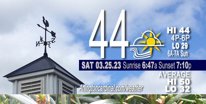
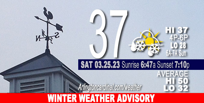
Saturday Hi 37, mostly cloudy, rain until 5p, snow <1", winds NE to NW to W, 16 to 17 to 7 MPH, G31 to 16 to 26 to 33 to 15 MPH, gusts end 2a Sunday
NWS CHGO | NWS HRLY | /NWSchicago | 🌡
ARLINGTON HEIGHTS WEATHER
▴ forecast7 (Arl. Hts.) | RADAR | WIDE RADAR
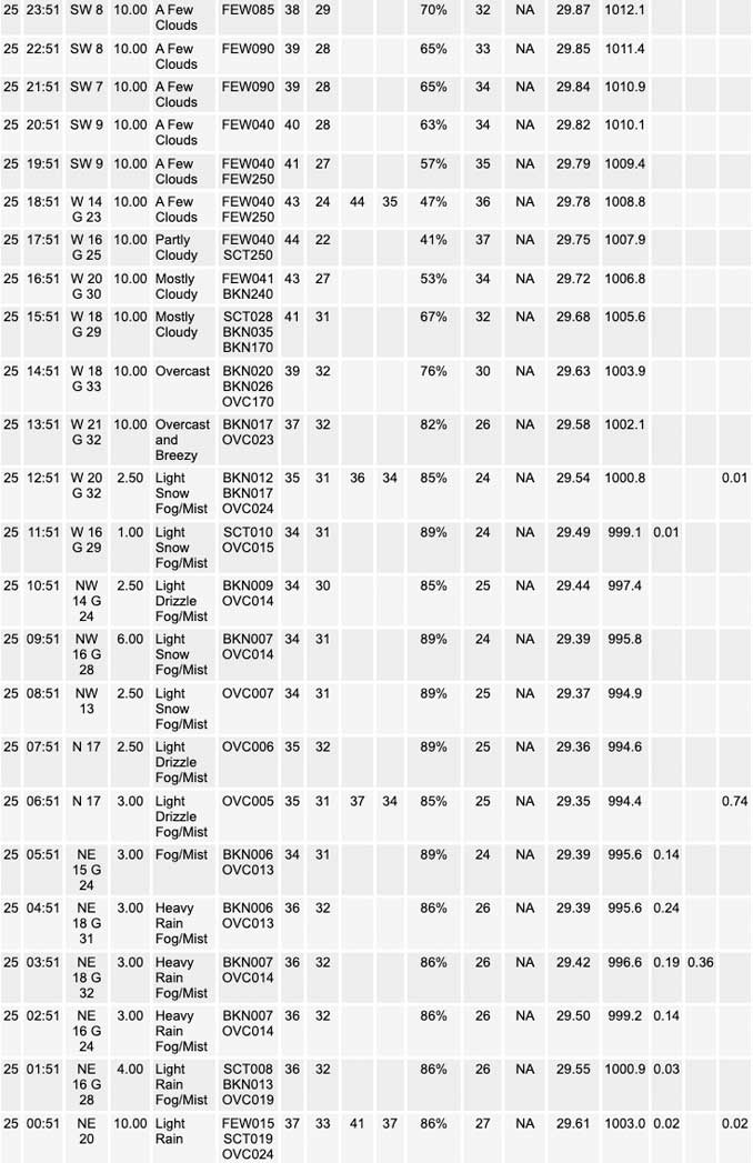
⏪ Hrly Data Table | Hrly Future Graph ⏩
IMPORTANT NOTE ON NWS DATA
⏪ Hrly Data Table | Hrly Future Graph ⏩
Hello mobile users! If you encounter a mobile “unfriendly” weather page, turn your phone sideways for a better view.
======================
Saturday and Saturday Evening …
Weather Hazards expected …
Limited Non Thunderstorm Wind Risk.
Elevated Snow Risk.
DISCUSSION…
Periods of heavy wet snow can be expected this morning, primarily northwest of a line from near Mendota to Waukegan. Snowfall rates of 1 to 2 inches per hour are possible in a narrow corridor across northwestern Illinois which will lead to snow-coated roadways and hazardous travel conditions.
Heaviest snow (3-7 inches) expected from about Antioch west to around 25 miles northwest of Rockford.
According to NWS Chicago, there is increasing concern that an encroaching dry slot is “robbing us” of cloud ice later this morning and keeping rain from transitioning over to snow, at least for a while over the central and southeastern Chicagoland. Forecast soundings suggest that once the dry slot moves in prior to daybreak, we will remain saturated only up to roughly 800 or 750mb. This should certainly be deep enough saturation to keep precip going into the morning, but a nearly isothermal profile through the low levels means the top of the saturated layer will be sitting near or just below freezing. We should see some mid level moisture recover into mid-morning as the TROWAL begins moving overhead and then we could see a period of snow further south and east. But, if this dry air does end up keeping much of the area under rain or drizzle this morning, then the sharp cutoff in snow totals we`re expecting will probably be even more pronounced than we thought. Snow will then taper off to the northeast through the afternoon. No major changes to snow totals with areas under the warning still expected to see around 6-9 inches by the end of the morning. No changes to headlines are planned at this time either.
======================
Winter Weather Advisory
URGENT – WINTER WEATHER MESSAGE
National Weather Service Chicago IL
428 AM CDT Sat Mar 25 2023DuPage-La Salle-Kendall-Northern Cook- Including the cities of Naperville, Wheaton, Downers Grove, Lombard, Carol Stream, Ottawa, Streator, La Salle, Mendota, Marseilles, Oswego, Yorkville, Plano, Evanston, Des Plaines, Schaumburg, Palatine, and Northbrook 428 AM CDT Sat Mar 25 2023
…WINTER WEATHER ADVISORY REMAINS IN EFFECT UNTIL 1 PM CDT THIS AFTERNOON…
* WHAT…Wet snow expected. Total snow accumulations ranging from 2 to 3 inches over northern portions of the counties to little or no accumulation southern portions of the counties. Winds gusting as high as 35 mph.
* WHERE…Mainly northern portions of DuPage, La Salle and Kendall Counties.
* WHEN…Until 1 PM CDT this afternoon.
* IMPACTS…Untreated roads will become covered with slushy snow accumulations and travel may become difficult for a period early this morning during the period of heaviest snow.
PRECAUTIONARY/PREPAREDNESS ACTIONS…
Slow down and use caution while traveling.
The latest road conditions for Illinois can be obtained on the internet at www.gettingaroundillinois.com.
O’HARE FORECAST …
Forecast Beginning Saturday, Mar. 25, 2023
Saturday: Drizzle and snow before 2pm, then a chance of snow between 2pm and 3pm, then a chance of rain and snow after 3pm. High near 37. North northeast wind around 15 mph becoming west northwest in the afternoon. Winds could gust as high as 35 mph. Chance of precipitation is 90%. Total daytime snow accumulation of less than one inch possible. Less than one-half inch in south Arlington Heights. Possibly no accumulation on pavement surfaces.
Saturday Night: Mostly clear, with a low around 26. West wind 5 to 10 mph, with gusts as high as 20 mph.
Sunday: Increasing clouds, with a high near 42. Calm wind becoming east northeast around 5 mph in the afternoon.
Sunday Night: A chance of rain and snow between 1am and 4am, then a chance of rain after 4am. Mostly cloudy, with a low around 32. East northeast wind 5 to 10 mph. Chance of precipitation is 30%.
Monday: A chance of rain and snow before 1pm, then a chance of rain between 1pm and 4pm, then a chance of rain and snow after 4pm. Mostly cloudy, with a high near 42. Northeast wind 10 to 15 mph. Chance of precipitation is 40%.
Monday Night: A chance of rain and snow before 10pm, then a chance of rain between 10pm and 4am, then a chance of rain and snow after 4am. Mostly cloudy, with a low around 30. Chance of precipitation is 30%.
Tuesday: A chance of rain and snow, mainly before 7am. Partly sunny, with a high near 44. Chance of precipitation is 30%.
Tuesday Night: Mostly clear, with a low around 27.
Wednesday: Partly sunny, with a high near 45.
Wednesday Night: A chance of rain. Mostly cloudy, with a low around 33.
Thursday: A chance of showers. Mostly cloudy, with a high near 45.
Thursday Night: Showers. Mostly cloudy, with a low around 39.
Friday: Showers likely. Mostly cloudy, with a high near 53.


CHICAGOWEATHERSTATION.COM

ChicagoWeatherStation.com I O’Hare Normal Temps/Precip I O’Hare Record Temps, Precip, Snow
LIVE RADAR | STORM TRACKS | UNISYS US IR SAT | UNISYS Midwest IR SAT | UNISYS More IR SAT
WunderMap® with Temperature/Wind Data || Google: Arlington Heights Area Temps | US TEMPS
Full Screen Motion Weather Radar (Wunderground.com)
Midwest Cloud Cover with Arlington Heights Weather Forecast
ChicagoWeatherStation.com I O’Hare Normal Temps/Precip I O’Hare Record Temps, Precip, Snow
SUNLIGHT DATA FOR SECURITY, TRAFFIC SAFETY, AND SPORTS
SunCalc.net data with solar azimuth and trajectory, times for dawn, sunrise, solar noon, sunset, dusk …
NIGHT SKY THIS MONTH …
Backyard stargazers get a monthly guide to the northern hemisphere’s skywatching events with “Tonight’s Sky.” Check the night sky objects for this month and past months in the playlist from the Space Telescope Science Institute YouTube channel (Musical track The Far River written by Jonn Serrie, from the album And the Stars Go With You courtesy of New World Music Ltd).
Get updates from The Cardinal ALL NEWS FEEDS on Facebook. Just ‘LIKE’ the ‘Arlington Cardinal Page (become a fan of our page). The updates cover all posts and sub-category posts from The Cardinal — Arlingtoncardinal.com. You can also limit feeds to specific categories. See all of The Cardinal Facebook fan pages at Arlingtoncardinal.com/about/facebook …
Help fund The Cardinal Arlingtoncardinal.com/sponsor
/////////////>
Area Forecast Discussion
National Weather Service Chicago/Romeoville, IL
649 AM CDT Sat Mar 25 2023
.SHORT TERM… Issued at 333 AM CDT Sat Mar 25 2023
Through Sunday…
As of 2AM, rain of varying intensities continues to fall on just about the whole area. Snow reports are beginning to close in on the western and northern CWA; a live webcam out of Sterling shows a steady wet snowfall so it`s reasonable to think portions of western Lee and Ogle Counties are seeing the same. Just over the past couple of hours, we`ve seen radar reflectivity flare up over parts of the western CWA and extending out over eastern IA. While this is likely due in part to some bright banding as the radar intersects big, wet flakes, this lines up awfully well with where SPC mesoanalysis is placing a swath of notable f-gen through the 850- 700mb layer, which is also where high res guidance suggests we`re seeing a great deal of synoptic ascent. Just above this layer, the RAP and HRRR are resolving some weak, albeit notable, upright instability. As the TROWAL axis propagates eastward over the next several hours, prominent f-gen and synoptic forcing are expected to persist over the northwestern CWA. Additionally, a good deal of negative EPV will progress northward into the western CWA closer to daybreak implying a greater potential for symmetric instability. All this is to say that periods of heavy snow remain likely into the daylight hours for areas under the winter storm warning.
Over the central and southeastern CWA, there is increasing concern in the encroaching dry slot robbing us of cloud ice later this morning and keeping rain from transitioning over to snow, at least for a while. Forecast soundings suggest that once the dry slot moves in prior to daybreak, we will remain saturated only up to roughly 800 or 750mb. This should certainly be deep enough saturation to keep precip going into the morning, but a nearly isothermal profile through the low levels means the top of the saturated layer will be sitting near or just below freezing. We should see some mid level moisture recover into mid-morning as the TROWAL begins moving overhead and then we could see a period of snow further south and east. But, if this dry air does end up keeping much of the area under rain or drizzle this morning, then the sharp cutoff in snow totals we`re expecting will probably be even more pronounced than we thought. Snow will then taper off to the northeast through the afternoon. No major changes to snow totals with areas under the warning still expected to see around 6-9 inches by the end of the morning. No changes to headlines are planned at this time either.
The break from the rain and snow tonight may be short-lived with another wave set to move over tomorrow. Overnight tonight, a rather potent little shortwave is forecast to dig out over the central Plains before progressing right over the area tomorrow morning and afternoon. At the surface, this translates to a center of low pressure that will track through central Illinois and drag its warm front across the southern CWA. Scattered snow showers will transition to rain through the morning for areas roughly south of I- 88. Along and south of the warm front, guidance is gathering as many as a few hundred J/kg of MUCAPE with moderate low and mid level lapse rates through the morning. It`s very realistic to think that we could see a couple of morning thunderstorms pop up near and south of the Kankakee River valley as a result. North of the front, some modest elevated instability could mean a decent rain or snow shower but nothing significant is forecast. More on this system as it continues into Sunday night in the long term discussion below.
Doom/NWS Chicago
