
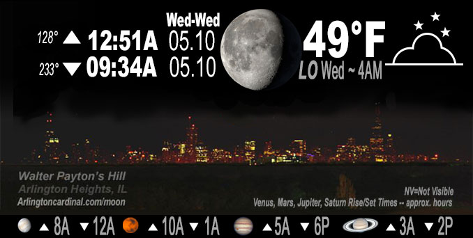
🌖 🌗 🌑 🌓 Waning Gibbous Moon, sky cover overnight Tue. to Wed. 40% to 21% to 22%, winds E to NE to ESE, 6 to 2 MPH, Low 49, 4a to 6a
NWS CHGO | NWS HRLY | /NWSchicago | 🌡
ARLINGTON HEIGHTS WEATHER
▴ forecast7 (Arl. Hts.) | RADAR | WIDE RADAR
IMPORTANT NOTE ON NWS DATA
Hello mobile users! If you encounter a mobile “unfriendly” weather page, turn your phone sideways for a better view.
======================
NIGHT FORECASTS …
NOTE: Keep in mind lunar rise and set times don’t always correspond with night weather and early morning lows because on some days during the month the moon is visible in the sky predominantly during the daytime hours.
Overnight Tuesday to Wednesday …
No Weather Hazards expected …
Sky cover amounts to patchy high cirrus conditions overnight.
DISCUSSION…
Weak surface high pressure was centered across the Great Lakes and southern Ontario this evening. Light synoptic east and northeast winds west of the surface ridge will allow for temps to cool into the 45-50 degree range overnight.
======================
O’HARE FORECAST …
Forecast Beginning Tuesday Night, May 09, 2023 …
Tuesday Night: Partly cloudy, with a low around 48. East northeast wind 5 to 10 mph becoming light in the evening.
Wednesday: Sunny, with a high near 77. Light east wind becoming east southeast 5 to 10 mph in the afternoon.
Wednesday Night: Partly cloudy, with a low around 54. East wind 5 to 10 mph.
ThursdayPartly sunny, with a high near 80. Southeast wind 5 to 10 mph, with gusts as high as 15 mph.
Thursday Night: A chance of showers between 1am and 4am, then a chance of showers and thunderstorms after 4am. Mostly cloudy, with a low around 61. East southeast wind around 5 mph, with gusts as high as 10 mph. Chance of precipitation is 30%.
Friday: Showers likely and possibly a thunderstorm before 10am, then showers likely between 10am and 1pm, then showers likely and possibly a thunderstorm after 1pm. Mostly cloudy, with a high near 76. Chance of precipitation is 70%.
Friday Night: Showers likely and possibly a thunderstorm. Mostly cloudy, with a low around 60. Chance of precipitation is 70%.
Saturday: Showers likely, mainly after 1pm. Mostly cloudy, with a high near 72.
Saturday Night: A chance of showers and thunderstorms. Mostly cloudy, with a low around 56.
Sunday: A chance of showers. Mostly cloudy, with a high near 65.
Sunday Night: Partly cloudy, with a low around 47.
Monday: Sunny, with a high near 72.
Monday Night: Mostly clear, with a low around 55.
Tuesday: Mostly sunny, with a high near 74.
O’Hare forecast archive and hourly weather observations archive are available HERE on the CARDINAL NEWS Magazine.
Arlingtoncardinal.com/moonphases
Arlingtoncardinal.com/nightsky
NIGHT SKY THIS MONTH …
Check the night sky objects for this month and past months in the playlist from the Space Telescope Science Institute YouTube channel Backyard stargazers get a monthly guide to the northern hemisphere’s skywatching events with “Tonight’s Sky” (Musical track The Far River written by Jonn Serrie, from the album And the Stars Go With You courtesy of New World Music Ltd. Musical track The Far River written by Jonn Serrie, from the album And the Stars Go With You courtesy of New World Music Ltd).
Telephoto lens, ISO 100, f/11, Shutter Speed 1/100 to 1/125 for the Moon.
Get updates from The Cardinal ALL NEWS FEEDS on Facebook. Just ‘LIKE’ the ‘Arlington Cardinal Page (become a fan of our page). The updates cover all posts and sub-category posts from The Cardinal — Arlingtoncardinal.com. You can also limit feeds to specific categories. See all of The Cardinal Facebook fan pages at Arlingtoncardinal.com/about/facebook …
Help fund The Cardinal Arlingtoncardinal.com/sponsor
Telephoto lens, ISO 1600, f/11, Shutter Speed 2.5″ for the skyline. The skyline exposure was toned down, and brightness and contrast was adjusted in Photoshop.
/////////////>
Area Forecast Discussion
National Weather Service Chicago/Romeoville, IL
1217 AM CDT Wed May 10 2023
.UPDATE… Issued at 839 PM CDT Tue May 9 2023
Going forecast is in good shape this evening, and have mainly only made some tweaks to increase sky cover a bit through this evening due to patchy high cirrus.
Weak surface high pressure was centered across the Great Lakes and southern Ontario this evening. Light synoptic east and northeast winds west of the surface ridge will allow for temps to cool into the 45-50 degree range overnight. Did increase sky cover a bit across mainly the IL portion of the forecast area through the late evening hours, for scattered/broken Patchy high cirrus noted in satellite and out the window views. This high cloud is associated with the right entrance region of a northwest-southeast oriented upper level jet streak across the Great Lakes region as well as some convective anvil debris from distant earlier storms across MN and the Plains, but should thin out with time overnight.
Otherwise, forecast has everything well in hand this evening, and other than some minor tweaks for temp/dew point trends, have made no other significant changes.
Ratzer
&&
.SHORT TERM… Issued at 305 PM CDT Tue May 9 2023
Through Wednesday night…
Quiet weather is in store through the short term period as high pressure remains overhead. Skies have been mostly clear early this afternoon though thin cirrus clouds are now drifting across northwest Illinois into the area along with a general haziness in the sky. Cirrus may linger into the evening eventually diminishing in coverage overnight. Temperatures tonight cool into the mid to upper 40s.
The center of the surface high drifts east into Wednesday returning much of the area to light southerly flow. Temperatures in turn tomorrow are expected to warm several degrees higher than seen today with highs in the upper 70s to near 80. Expect mid 60s along the shore, however, with an early afternoon lake breeze push expected.
Petr/NWS Chicago
