
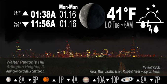
🌘 🌑 🌗 🌕 Waning Crescent Moon, rain ends by 9p, sky cover overnight Mon. to Tue. 100% to 67% to 94%, winds SSE to SW, 15 to 11 to 14 MPH, G25 to 23 MPH, Low 41, 6a to 11a
NWS CHGO | NWS HRLY | /NWSchicago | 🌡
ARLINGTON HEIGHTS WEATHER
▴ forecast7 (Arl. Hts.) | RADAR | WIDE RADAR
IMPORTANT NOTE ON NWS DATA
======================
NIGHT FORECASTS …
NOTE 1: Forecast and information text below may refer to a previous night on Arlingtoncardinal.com, and might not be updated until late afternoon, evening, or overnight. However, Night Sky archives on CARDINAL NEWS Magazine include text forecasts that correspond to the lunar phase graphic above.
NOTE 2: Keep in mind lunar rise and set times don’t always correspond with night weather and early morning lows because on some days during the month the moon is visible in the sky predominantly during the daytime hours.
Overnight Monday/Tuesday …
Weather Hazards expected …
Limited Thunderstorm Risk (7:00 p.m. to 8:00 p.m. in Arlington Heights and nearby communities).
DISCUSSION…
A few thunderstorms are possible this evening. Some could produce small hail and gusty winds. A few sprinkles or snowflakes cannot be ruled out during the Tuesday morning hours near the Wisconsin State line.
When using forecast highs and lows for both Monday (today) and Tuesday (tomorrow) to determine forecast daily average temperatures, it appears the first 17 days of January 2023 could turn out to produce an average that becomes the second warmest on record at both Chicago and Rockford — though much will depend on temperatures right at midnight Monday/Tuesday.
Hello mobile users! If you encounter mobile “unfriendly” weather page, turn your phone sideways for a better view.
======================
O’HARE FORECAST …
Forecast Beginning Monday Night, Jan. 16, 2023 …
Monday Night: Scattered showers and thunderstorms before 9pm, then isolated showers between 9pm and 10pm. Mostly cloudy, with a low around 40. Southwest wind 10 to 15 mph, with gusts as high as 25 mph. Chance of precipitation is 40%.
Tuesday: Isolated showers before noon. Cloudy, with a high near 42. West southwest wind 10 to 15 mph, with gusts as high as 30 mph. Chance of precipitation is 20%.
Tuesday Night: Mostly cloudy, with a low around 32. West wind 5 to 15 mph, with gusts as high as 25 mph.
Wednesday: A 20 percent chance of rain after 3pm. Mostly cloudy, with a high near 40. West northwest wind 5 to 10 mph becoming east northeast in the afternoon.
Wednesday Night: Rain. Low around 35. Chance of precipitation is 90%.
Thursday: Rain likely before noon, then a chance of rain and snow. Cloudy, with a high near 40. Chance of precipitation is 60%.
Thursday Night: Cloudy, with a low around 28.
Friday: Mostly cloudy, with a high near 35.
Friday Night: Mostly cloudy, with a low around 25.
Saturday: Mostly cloudy, with a high near 34.
Saturday Night: Mostly cloudy, with a low around 27.
Sunday: Partly sunny, with a high near 38.
O’Hare forecast archive and hourly weather observations archive are available HERE on the CARDINAL NEWS Magazine.
Arlingtoncardinal.com/moonphases
Arlingtoncardinal.com/nightsky
NIGHT SKY THIS MONTH …
Check the night sky objects for this month and past months in the playlist from the Space Telescope Science Institute YouTube channel Backyard stargazers get a monthly guide to the northern hemisphere’s skywatching events with “Tonight’s Sky” (Musical track The Far River written by Jonn Serrie, from the album And the Stars Go With You courtesy of New World Music Ltd. Musical track The Far River written by Jonn Serrie, from the album And the Stars Go With You courtesy of New World Music Ltd).
Telephoto lens, ISO 100, f/11, Shutter Speed 1/100 to 1/125 for the Moon.
Get updates from The Cardinal ALL NEWS FEEDS on Facebook. Just ‘LIKE’ the ‘Arlington Cardinal Page (become a fan of our page). The updates cover all posts and sub-category posts from The Cardinal — Arlingtoncardinal.com. You can also limit feeds to specific categories. See all of The Cardinal Facebook fan pages at Arlingtoncardinal.com/about/facebook …
Help fund The Cardinal Arlingtoncardinal.com/sponsor
Telephoto lens, ISO 1600, f/11, Shutter Speed 2.5″ for the skyline. The skyline exposure was toned down, and brightness and contrast was adjusted in Photoshop.
Area Forecast Discussion
National Weather Service Chicago/Romeoville, IL
251 PM CST Mon Jan 16 2023
.SHORT TERM… Issued at 251 PM CST Mon Jan 16 2023
Through Tuesday night…
An area of showers continues to move through northeastern Illinois and northwest Indiana ahead of a warm front that is currently being analyzed along a Sterling, IL to Pontiac, IL line. While some of these showers have shown signs of vertical development on radar, they have struggled to produce any lightning recently. The reason for the lack of lightning so far is likely due the low topped nature of these more robust showers (tops under 16,000 ft) and lack of surface based instability as noted on recent aircraft soundings out of MDW. However, the aircraft and forecast soundings are still showing mid-level lapse rates on the order of 6 to 7 C/km which is sufficient to support some convective development and the chance of an isolated lightning strike or two as these showers continue to move northeastward towards the open waters of Lake Michigan over the next hour or two.
The warm front will continue to lift northward through northeastern Illinois this evening as the 993 mb surface low currently over central Iowa continues to move northeastward into southern Wisconsin which will drag a cold front through the area this evening. As this occurs dew points are expected to continue to increase into the upper 40s with a couple locations possibly seeing 50 degree dew points in our far southern CWA which will set the stage for the development of additional showers and possibly a few thunderstorms through this evening. While the increasing dew points will allow for some destabilization (MUCAPE values of a few hundred J/kg) forecast soundings continue to indicate that this instability should remain elevated. Regardless, forecast soundings are also showing decent shear profiles in place in the warm sector this evening which could allow for some thunderstorms to become better organized and possibly contain a marginal threat for some small hail and gusty winds. There is also the very small chance (less than 2%) that a brief spin u Pcould occur if some surface based instability can be realized. Again this potential is very low, but is something worth keeping an eye on through this evening especially across our southern CWA where forecast soundings show some slightly better chances for surface based instability. Any already low severe risk will end by about 8 PM as nocturnal CIN increases. Any showers and/or storms that do develop this evening should move out of the area around midnight with the cold front.
Otherwise, expect mostly cloudy skies and breezy conditions to persist through Tuesday evening. Winds will become westerly overnight behind the aforementioned cold front with gusts in the 25 to 30 mph range returning Tuesday afternoon. Temperatures will also continue to warm through this evening with highs looking to top out in the mid to upper 40s to near 50 by midnight tonight. Tuesday`s high is expected to occur shortly after midnight with temperatures gradually diminishing through the day before settling into the low to mid 30s Tuesday night.
Yack/NWS Chicago
