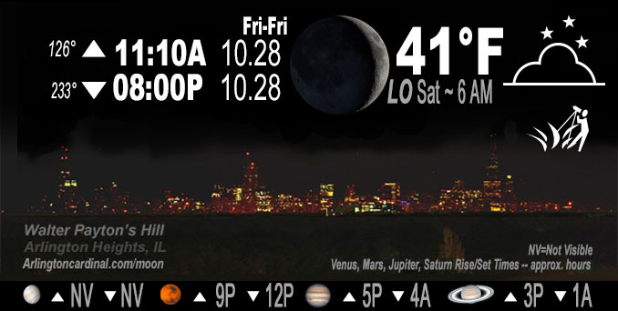
🌒 🌓 🌕 🌗 Waxing Crescent Moon, sky cover overnight Fri. to Sat., 8% to 37%, winds SE to ENE to E, 6 to 1 MPH, Low 41, 6a to 8a

NWS CHGO | NWS HRLY | /NWSchicago | 🌡
ARLINGTON HEIGHTS WEATHER
▴ forecast7 (Arl. Hts.) | RADAR | WIDE RADAR
IMPORTANT NOTE ON NWS DATA
======================
No Watches or Warnings overnight Thursday evening.
Updates at Arlingtoncardinal.com/NWSChicago
Friday Night.
No weather hazards expected…
Patchy fog is possible tonight in northeast Illinois, otherwise a quiet weather continues today into the weekend as expansive surface high pressure remains dominant across the Great Lakes into New England. High level cloudiness will continue to shift east early this morning with mostly clear skies expected for much of the day. More sun and even warmer Saturday.
Hello mobile users! If you encounter mobile “unfriendly” weather page, turn your phone sideways for a better view.
======================
O’HARE FORECAST …
Forecast Beginning Friday Night, Oct. 28, 2022
Friday Night: Patchy fog after 3am. Otherwise, mostly clear, with a low around 40. East northeast wind around 5 mph becoming calm in the evening.
Saturday: Patchy fog before 9am. Otherwise, sunny, with a high near 63. Calm wind becoming east around 5 mph in the afternoon.
Saturday Night: Increasing clouds, with a low around 46. East wind around 5 mph becoming calm in the evening.
Sunday: A 30 percent chance of showers after 1pm. Cloudy, with a high near 62. Calm wind becoming east around 5 mph in the afternoon.
Sunday Night: A 20 percent chance of showers before 1am. Mostly cloudy, with a low around 46.
Monday: Partly sunny, with a high near 63.
Monday Night: Mostly clear, with a low around 44.
Tuesday: Sunny, with a high near 66.
Tuesday Night: Mostly clear, with a low around 46.
Wednesday: Sunny, with a high near 67.
Wednesday Night: Partly cloudy, with a low around 51.
Thursday: Mostly sunny, with a high near 67.
O’Hare forecast archive and hourly weather observations archive are available HERE on the CARDINAL NEWS Magazine.
Arlingtoncardinal.com/moonphases
Arlingtoncardinal.com/nightsky
NIGHT SKY THIS MONTH …
Check the night sky objects for this month and past months in the playlist from the Space Telescope Science Institute YouTube channel Backyard stargazers get a monthly guide to the northern hemisphere’s skywatching events with “Tonight’s Sky” (Musical track The Far River written by Jonn Serrie, from the album And the Stars Go With You courtesy of New World Music Ltd. Musical track The Far River written by Jonn Serrie, from the album And the Stars Go With You courtesy of New World Music Ltd).
Telephoto lens, ISO 100, f/11, Shutter Speed 1/100 to 1/125 for the Moon.
Get updates from The Cardinal ALL NEWS FEEDS on Facebook. Just ‘LIKE’ the ‘Arlington Cardinal Page (become a fan of our page). The updates cover all posts and sub-category posts from The Cardinal — Arlingtoncardinal.com. You can also limit feeds to specific categories. See all of The Cardinal Facebook fan pages at Arlingtoncardinal.com/about/facebook …
Help fund The Cardinal Arlingtoncardinal.com/sponsor
Telephoto lens, ISO 1600, f/11, Shutter Speed 2.5″ for the skyline. The skyline exposure was toned down, and brightness and contrast was adjusted in Photoshop.
Area Forecast Discussion
National Weather Service Chicago/Romeoville, IL
1213 AM CDT Sat Oct 29 2022
.UPDATE…
Issued at 831 PM CDT Fri Oct 28 2022
The forecast is in good shape with few changes needed this evening.
A recent hand analysis of the surface pressure, dew point, and wind fields reveals a stout 1030+mb surface high pressure system centered in the northeastern United States with a westward surface ridge extension through the Great Lakes. Full sunshine earlier this afternoon facilitated the development of a late-season lake breeze, which has since “washed out” across the Chicago metropolitan area. What`s left behind is a shallow (~200-300 ft deep per AMDAR soundings) localized pool of marine moisture characterized by surface dew points in the lower 40s extending more or less along and east of Interstate 355 and a few miles south of Interstate 80.
With clear skies, calm winds, and subsidence all being provided by the surface ridge over the Great Lakes, ideal radiational cooling conditions will allow for temperatures to (continue) nosediving through the overnight hours with lows likely to hit the low to mid 30s everywhere outside the urban core of Chicago. Considering low temperatures are poised to fall below where dew point temperatures were this afternoon (mid to upper 30s; the so-called “cross-over” temperatures), areas of fog appear all but certain to develo Ptonight with the densest likely within the aforementioned marine airmass across the Chicago metropolitan area. Visibility at Waukegan National Airport is already below 2 miles, giving confidence in such a forecast scenario. For this reason, opted to “bump” up wording of fog but held short of an explicit mention of anything dense as even the most favorable or obvious set-ups sometimes fail to produce.
Updated products will be sent shortly.
Borchardt/NWS Chicago

