
🌕 🌗 🌑 🌓 Full Moon, sky cover overnight Tue. to Wed. 50% to 23% to 505, winds SE to SSE to S, 10 to 7 MPH, G14 to 13 MPH, Low 41, 11p to 2a
NWS CHGO | NWS HRLY | /NWSchicago | 🌡
ARLINGTON HEIGHTS WEATHER
▴ forecast7 (Arl. Hts.) | RADAR | WIDE RADAR
IMPORTANT NOTE ON NWS DATA
======================
Tuesday overnight …
No weather hazards expected…
DISCUSSION…
Another quiet day across the area with seasonable temperatures in the 50s.
Hello mobile users! If you encounter mobile “unfriendly” weather page, turn your phone sideways for a better view.
======================
O’HARE FORECAST …
Forecast Beginning Tuesday Night, Nov. 08, 2022
Tuesday Night: Partly cloudy, with a low around 45. South southeast wind 5 to 10 mph, with gusts as high as 15 mph.
Wednesday: Mostly sunny, with a high near 66. South wind 5 to 10 mph, with gusts as high as 15 mph.
Wednesday Night: Partly cloudy, with a low around 56. South southwest wind around 10 mph, with gusts as high as 15 mph.
Thursday: Partly sunny, with a high near 73.
Thursday Night: A 20 percent chance of rain. Mostly cloudy, with a low around 46.
Veterans Day: Mostly sunny, with a high near 52.
Friday Night: Partly cloudy, with a low around 28.
Saturday: Mostly cloudy, with a high near 37.
Saturday Night: Mostly cloudy, with a low around 25.
Sunday: Partly sunny, with a high near 36.
Sunday Night: Partly cloudy, with a low around 24.
Monday: Mostly sunny, with a high near 38.
O’Hare forecast archive and hourly weather observations archive are available HERE on the CARDINAL NEWS Magazine.
Arlingtoncardinal.com/moonphases
Arlingtoncardinal.com/nightsky
NIGHT SKY THIS MONTH …
Check the night sky objects for this month and past months in the playlist from the Space Telescope Science Institute YouTube channel Backyard stargazers get a monthly guide to the northern hemisphere’s skywatching events with “Tonight’s Sky” (Musical track The Far River written by Jonn Serrie, from the album And the Stars Go With You courtesy of New World Music Ltd. Musical track The Far River written by Jonn Serrie, from the album And the Stars Go With You courtesy of New World Music Ltd).
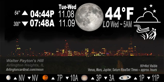
Telephoto lens, ISO 100, f/11, Shutter Speed 1/100 to 1/125 for the Moon.
Get updates from The Cardinal ALL NEWS FEEDS on Facebook. Just ‘LIKE’ the ‘Arlington Cardinal Page (become a fan of our page). The updates cover all posts and sub-category posts from The Cardinal — Arlingtoncardinal.com. You can also limit feeds to specific categories. See all of The Cardinal Facebook fan pages at Arlingtoncardinal.com/about/facebook …
Help fund The Cardinal Arlingtoncardinal.com/sponsor
Telephoto lens, ISO 1600, f/11, Shutter Speed 2.5″ for the skyline. The skyline exposure was toned down, and brightness and contrast was adjusted in Photoshop.
Area Forecast Discussion
National Weather Service Chicago/Romeoville, IL
1058 PM CST Tue Nov 8 2022
.SHORT TERM… Issued at 300 PM CST Tue Nov 8 2022
Through Wednesday…
Another quiet day across the area with seasonable temperatures in the 50s. Upper ridging continues to amplify across the eastern CONUS today with an associated stout 1040+ hPa surface high sliding further east along the eastern U.S.-Canadian border setting the stage for our anticipated warm up. Accordingly, easterly surface winds will turn southeast and overnight and southerly into the day on Wednesday. A weak shortwave is expected to round the western side of the ridge to our northwest Wednesday morning. At this hour there are showers and isolated embedded thunderstorms beneath this feature across northwest Iowa and southwest Minnesota. As this lifts to the northeast this may bring in an axis of weak MUCAPE into the area Wednesday morning. Some hi-res guidance is even trying to develop a few spotty showers into our area during that time. Forecast soundings still look pretty dry in the mid and low levels so opted to account for this with a mention of isolated sprinkles in the official forecast but an isolated shower certainly cannot be ruled out. Even with a few spotty sprinkles/showers around in the morning, persistent southerly surface flow will help temperatures warm 10+ degrees above normal with highs in the mid to upper 60s!
Petr/NWS
