
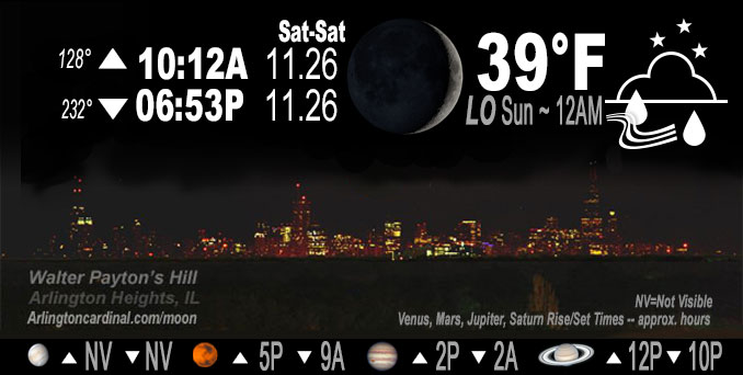
🌒 🌓 🌕 🌗 Waxing Crescent Moon, rain after 2a, sky cover overnight Sat. to Sun. 70% to 100%, winds SW to S to NE, 10 to 2 to 11 MPH, Low 39, 12a to 6a
NWS CHGO | NWS HRLY | /NWSchicago | 🌡
ARLINGTON HEIGHTS WEATHER
▴ forecast7 (Arl. Hts.) | RADAR | WIDE RADAR
IMPORTANT NOTE ON NWS DATA
======================
Saturday Night …
No Weather Hazards expected…
This Weather Outlook is for portions of North Central Illinois…Northeast Illinois and Northwest Indiana.
DISCUSSION…
Sunday’s primary highlight in the forecast is rain moving in tonight preceding dreary weather with steady rain expected from a storm system arriving from the southwest.
GOES 16 satellite shows water vapor channels spinning up across northern Texas into parts of southern Oklahoma. High clouds moved into Chicagoland late this afternoon, early evening.
The track of the upcoming storm system will be northeastward across the Ozarks and into the Mid-Mississippi Valley. A northward surge of moisture, originating from the western Gulf, and preceding the storm system, will drive a notable precipitation shield northward across central Illinois and into parts of northern Illinois and Indiana tonight. The deeper Gulf moisture (Precipitable waters ~1″) is forecast to move into southern counties of Chicagoland, south of I-80, late tonight after 2:00 a.m. Moderate rates of precipitation are expected south of I-80 during the overnight hours. Precipitation amounts forecast for Arlington Heights and the northwest suburbs have trended downward to about 0.33 inch of rain with peak precipitation from 8:00 a.m. to 2:00 p.m., and rain ending by 5:00 p.m. Mild weather follows Monday until Thursday, December 1, 2022 with Tuesday and Wednesday looking like the best days.
Hello mobile users! If you encounter mobile “unfriendly” weather page, turn your phone sideways for a better view.
======================
O’HARE FORECAST …
Forecast Beginning Saturday Night, Nov. 26, 2022
Saturday Night: A 50 percent chance of rain, mainly after 4am. Cloudy, with a low around 39. South wind 5 to 10 mph becoming light and variable.
Sunday: Rain, mainly before 3pm. High near 43. Breezy, with a north wind 5 to 10 mph increasing to 15 to 20 mph in the afternoon. Winds could gust as high as 30 mph. Chance of precipitation is 90%. New precipitation amounts between a quarter and half of an inch possible.
Sunday Night: Cloudy, then gradually becoming partly cloudy, with a low around 29. North northwest wind 10 to 15 mph decreasing to 5 to 10 mph after midnight. Winds could gust as high as 25 mph.
Monday: Mostly sunny, with a high near 46. West northwest wind 5 to 10 mph becoming south in the afternoon. Winds could gust as high as 15 mph.
Monday Night: Mostly cloudy, with a low around 37. South wind around 10 mph, with gusts as high as 15 mph.
Tuesday: A 30 percent chance of rain after noon. Mostly cloudy, with a high near 55. Breezy.
Tuesday Night: Rain, mainly before midnight. Low around 34. Chance of precipitation is 80%.
Wednesday: A chance of rain, mixing with snow after 8am, then gradually ending. Mostly cloudy, with a high near 40. Breezy.
Wednesday Night: Partly cloudy, with a low around 22. Breezy.
Thursday: Sunny, with a high near 34.
Thursday Night: Partly cloudy, with a low around 27.
Friday: Mostly sunny, with a high near 43.
Friday Night: Mostly cloudy, with a low around 30.
Saturday: Partly sunny, with a high near 41.
O’Hare forecast archive and hourly weather observations archive are available HERE on the CARDINAL NEWS Magazine.
Arlingtoncardinal.com/moonphases
Arlingtoncardinal.com/nightsky
NIGHT SKY THIS MONTH …
Check the night sky objects for this month and past months in the playlist from the Space Telescope Science Institute YouTube channel Backyard stargazers get a monthly guide to the northern hemisphere’s skywatching events with “Tonight’s Sky” (Musical track The Far River written by Jonn Serrie, from the album And the Stars Go With You courtesy of New World Music Ltd. Musical track The Far River written by Jonn Serrie, from the album And the Stars Go With You courtesy of New World Music Ltd).
Telephoto lens, ISO 100, f/11, Shutter Speed 1/100 to 1/125 for the Moon.
Get updates from The Cardinal ALL NEWS FEEDS on Facebook. Just ‘LIKE’ the ‘Arlington Cardinal Page (become a fan of our page). The updates cover all posts and sub-category posts from The Cardinal — Arlingtoncardinal.com. You can also limit feeds to specific categories. See all of The Cardinal Facebook fan pages at Arlingtoncardinal.com/about/facebook …
Help fund The Cardinal Arlingtoncardinal.com/sponsor
Telephoto lens, ISO 1600, f/11, Shutter Speed 2.5″ for the skyline. The skyline exposure was toned down, and brightness and contrast was adjusted in Photoshop.
Area Forecast Discussion Two of Two
National Weather Service Chicago/Romeoville, IL
544 PM CST Sat Nov 26 2022
.SHORT TERM… Issued at 234 PM CST Sat Nov 26 2022
Through Sunday night…
The primary highlight in the short term centers around the dreary weather with rain expected across the area late tonight into Sunday in association with a storm system shifting across the region.
While conditions across the area early this afternoon are currently dry and mild, we do not have to look too far to our southwest to see the beginnings of our next approaching storm system, which is depicted nicely in the GOES 16 water vapor channels spinning up across northern TX into parts of southern OK. We are even now beginning to see signs of higher level cloud cover shifting northeastward into our area. Expect this cloud cover to become thicker with time through this evening as mid and higher level moisture continues to increase in advance of the southern Plains storm system.
With time tonight the track of this storm system will take it northeastward across the Ozarks and into the Mid-Mississippi Valley. A northward surge of moisture (originating from the western Gulf) preceding the storm system will drive a notable precipitation shield northward across central and into parts of northern IL and IN tonight. The deeper Gulf moisture (Precipitable waters ~1″) is forecast to shift into my southern counties (south of I-80) late tonight after 2 am, and this is expected to support some efficient moderate rates within this area through the overnight hours. In fact, rainfall amounts in my southern counties prior to daybreak Sunday morning may approach, or even exceed an inch. In sharp contrast, the rainfall looks to struggle to shift into far northern IL (north of I-80) tonight due to the impacts of a stubborn dry airmass currently overhead, which only looks to become reinforced by a northeasterly wind shift. For this reason, it may not be until towards daybreak Sunday morning that the rainfall makes it into far northern IL, especially towards the WI state line.
Not much has changed with the forecast thinking for Sunday, with it expected to be a dreary day with a cold rain and increasingly breezy northerly winds. There still remains the possibility that some of the rain could mix with or change to a short period of wet snow before ending over far northern and northwestern sections of the area late Sunday morning into the early afternoon as colder air filters into the deformation precipitation shield. However, this still appears to be a low chance, and if it does, little to no accumulation is anticipated due to warm ground temperatures. Otherwise, expect the precipitation to come to an end during the late afternoon and evening as the storm system quickly shifts towards New England.
KJB/NWS Chicago
