
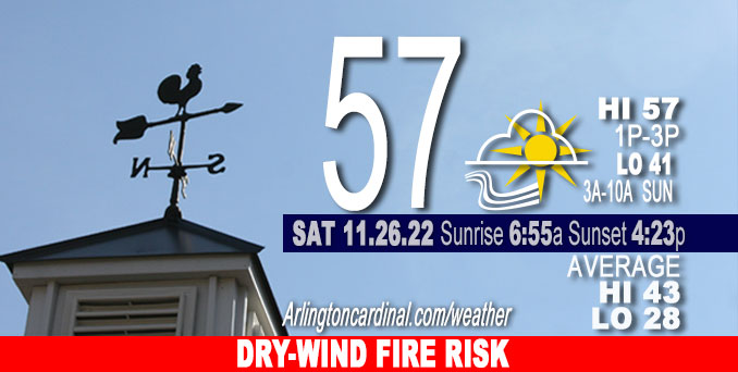
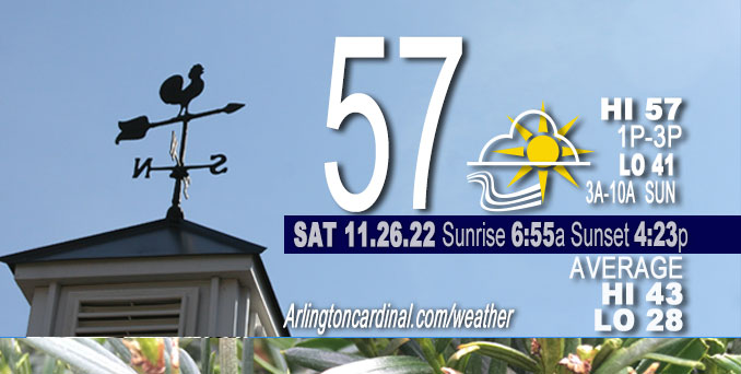
SATURDAY Hi 57, mostly sunny, increasing clouds after 2p, winds SW to SSW, 15 to 3 MPH, G26 to 17 MPH, until 5p
NWS CHGO | NWS HRLY | /NWSchicago | 🌡
ARLINGTON HEIGHTS WEATHER
▴ forecast7 (Arl. Hts.) | RADAR | WIDE RADAR
⏪ Hrly Data Table | Hrly Future Graph ⏩
IMPORTANT NOTE ON NWS DATA
⏪ Hrly Data Table | Hrly Future Graph ⏩
======================
Saturday and Saturday Night …
Weather Hazards expected…
This Weather Outlook is for portions of North Central Illinois … Northeast Illinois and Northwest Indiana.
Winnebago-Boone-McHenry-Lake IL-Ogle-Lee-De Kalb-Kane-DuPage-La Salle-Kendall-Grundy-Kankakee-Livingston-Iroquois-Ford-Northern Cook-Central Cook-Southern Cook-Northern Will-Southern Will-Eastern Will-Lake IN-Porter-Newton-Jasper-Benton-
421 AM CST Sat Nov 26 2022
Elevated Fire Weather Risk — Dry and breezy conditions this afternoon will result in an increased threat for the more rapid spread of brush and grass fires until sunset.
DISCUSSION…
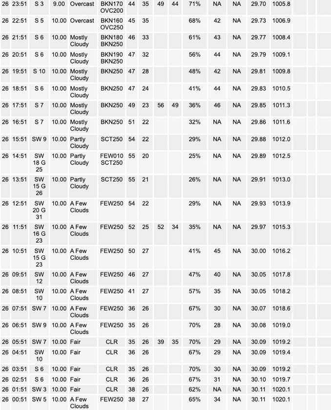
Great late November weather Saturday with seasonally mild temperatures and plenty of sunshine in the morning after noon. Clouds in southern Illinois will gradually move north in the late afternoon ahead of rain that will arrive in Arlington Heights around 2:00 a.m. Almost one-half inch of rain is possible between 1:00 a.m. and 5:00 p.m. with a much cooler day Sunday (High 42).
Normally high temps are in the low to mid 40s in late November, but mid 50s, and possibly upper 50s may be recorded if the clouds don`t fill in too quickly late Saturday.
Hello mobile users! If you encounter mobile “unfriendly” weather page, turn your phone sideways for a better view.
======================
O’HARE FORECAST …
Forecast Beginning Saturday, Nov. 26, 2022
Saturday: Mostly sunny, with a high near 57. South southwest wind 10 to 15 mph, with gusts as high as 25 mph.
Saturday Night: Rain, mainly after 3am. Low around 41. South wind 5 to 10 mph becoming light and variable. Chance of precipitation is 90%. New precipitation amounts of less than a tenth of an inch possible.
Sunday: Rain, mainly before 3pm. High near 42. Breezy, with a north wind 5 to 10 mph increasing to 15 to 20 mph in the afternoon. Winds could gust as high as 30 mph. Chance of precipitation is 100%. New precipitation amounts between a quarter and half of an inch possible.
Sunday Night: Cloudy, then gradually becoming partly cloudy, with a low around 31. North northwest wind 5 to 15 mph, with gusts as high as 25 mph.
Monday: Mostly sunny, with a high near 45. Northwest wind 5 to 10 mph becoming south in the afternoon. Winds could gust as high as 20 mph.
Monday Night: Mostly cloudy, with a low around 37.
Tuesday: A 40 percent chance of rain after noon. Mostly cloudy, with a high near 54.
Tuesday Night: Rain likely, mainly before midnight. Mostly cloudy, with a low around 33.
Wednesday: A chance of snow before noon. Partly sunny, with a high near 36. Breezy.
Wednesday Night: Partly cloudy, with a low around 21.
Thursday: Sunny, with a high near 34.
Thursday Night: Partly cloudy, with a low around 28.
Friday: Partly sunny, with a high near 43.


CHICAGOWEATHERSTATION.COM

ChicagoWeatherStation.com I O’Hare Normal Temps/Precip I O’Hare Record Temps, Precip, Snow
LIVE RADAR | STORM TRACKS | UNISYS US IR SAT | UNISYS Midwest IR SAT | UNISYS More IR SAT
WunderMap® with Temperature/Wind Data || Google: Arlington Heights Area Temps | US TEMPS
Full Screen Motion Weather Radar (Wunderground.com)
Midwest Cloud Cover with Arlington Heights Weather Forecast
ChicagoWeatherStation.com I O’Hare Normal Temps/Precip I O’Hare Record Temps, Precip, Snow
SUNLIGHT DATA FOR SECURITY, TRAFFIC SAFETY, AND SPORTS
SunCalc.net data with solar azimuth and trajectory, times for dawn, sunrise, solar noon, sunset, dusk …
NIGHT SKY THIS MONTH …
Backyard stargazers get a monthly guide to the northern hemisphere’s skywatching events with “Tonight’s Sky.” Check the night sky objects for this month and past months in the playlist from the Space Telescope Science Institute YouTube channel (Musical track The Far River written by Jonn Serrie, from the album And the Stars Go With You courtesy of New World Music Ltd).
Get updates from The Cardinal ALL NEWS FEEDS on Facebook. Just ‘LIKE’ the ‘Arlington Cardinal Page (become a fan of our page). The updates cover all posts and sub-category posts from The Cardinal — Arlingtoncardinal.com. You can also limit feeds to specific categories. See all of The Cardinal Facebook fan pages at Arlingtoncardinal.com/about/facebook …
Help fund The Cardinal Arlingtoncardinal.com/sponsor
Area Forecast Discussion
National Weather Service Chicago/Romeoville, IL
1153 AM CST Sat Nov 26 2022
.SHORT TERM… Issued at 330 AM CST Sat Nov 26 2022
Through Sunday…
Today through Mid Evening:
Given the date, a nice day in store with a sunny start, followed by high and mid-level clouds streaming in during the afternoon. A modest tightening of the pressure gradient, a 900 mb wind maxima of near or just over 30 kt over far northern Illinois, and mixing up near 900 mb will support breezy southwesterly winds. Gusts could briefly reach 35 mph in far northeast Illinois between about noon and 3pm, 25-30 mph north of I-80 and up to 25 mph to the south. The still dry air mass from the departing high pressure should support some mixing out of dew points and also contribute to highs in the 53-57F range despite afternoon increasing clouds. For the above reasons, we have messaged an elevated fire weather risk in the HWO, FWF, and morning WxStory. The evening will get off to a quiet start in advance of our weather- maker for later tonight and Sunday.
Late this Evening-Sunday Evening:
Key Messages:
* Rain: A pronounced surge of well above late November normal moisture and strengthening large scale forcing from a deepening surface low to the south will result in a large area of rain overcoming initial dry air and spreading south to north toward and after midnight. Noted a trend toward a sharper cut-off on the northwest periphery of the system (that could be sharper than in grids), but not much change in message for areas south of the Illinois-Kankakee Rivers where up to 1.25″ remains quite feasible through mid Sunday, with amounts tapering north. Could be temporary heavy rain rates and even some isolated embedded thunder on Sunday morning. The highest rainfall rates will occur from within an hour or two of onset until mid day Sunday.
* Potential Mix or Brief Flip to Wet Snow Sunday: Deepening surface low of 992-993 mb tracking just to our southeast then east will result in blustery north to north-northwesterly winds gusting up to 25-35 mph (possibly up to 40 mph Indiana shore). In addition, cold advection will lower freezing levels, and some potential for dynamic cooling (such as on 06z 12km NAM) from strong forcing, transient f-gen aided mesoscale banding, and steep mid-upper level lapse rates could result in a mix or fli P to very wet, non-accumulating snow near and west of an Antioch to Elgin to Mendota line. Still about a 20% chance of this from the mid-late morning Sunday into the early-mid afternoon in system deformation area before it departs northeast. Even if snow does occur, impacts will be mitigated (primarily reduced visibility) by well above freezing air and pavement temps.
All in all, following a nice stretch, Sunday will be a dreary, raw day (insert your preferred terminology for inclement weather), with temps nearly flat-lining in the upper 30s to mid 40s and the aforementioned blustery winds. Any lingering lighter rain over northwest Indiana will end Sunday evening.
Castro/NWS Chicago
