
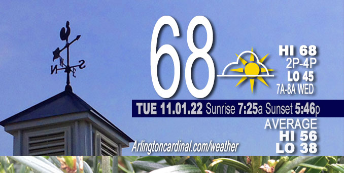
TUESDAY Hi 68°F, mostly sunny, winds SW to SSW, 6 to 7 to 5 MPH
NWS CHGO | NWS HRLY | /NWSchicago | 🌡
ARLINGTON HEIGHTS WEATHER
▴ forecast7 (Arl. Hts.) | RADAR | WIDE RADAR
⏪ Hrly Data Table | Hrly Future Graph ⏩
IMPORTANT NOTE ON NWS DATA
⏪ Hrly Data Table | Hrly Future Graph ⏩
======================
No Watches or Warnings Tuesday
Beautiful, sunny skies Tuesday
Hello mobile users! If you encounter mobile “unfriendly” weather page, turn your phone sideways for a better view.
======================
O’HARE FORECAST …
Forecast Beginning Tuesday, Nov. 01, 2022
Tuesday Afternoon: Sunny, with a high near 68. South southwest wind around 5 mph, with gusts as high as 10 mph.
Tuesday Night: Mostly clear, with a low around 45. South wind around 5 mph.
Wednesday: Sunny, with a high near 70. South wind 5 to 10 mph.
Wednesday Night: Partly cloudy, with a low around 51. South wind 5 to 10 mph.
Thursday: Mostly sunny, with a high near 71. South wind 5 to 15 mph, with gusts as high as 25 mph.
Thursday Night: Mostly cloudy, with a low around 58.
Friday: A 20 percent chance of rain after 1pm. Cloudy, with a high near 70.
Friday Night: A chance of rain after 1am. Cloudy, with a low around 58.
Saturday: A chance of rain. Cloudy, with a high near 67. Breezy.
Saturday Night: Rain likely. Mostly cloudy, with a low around 51. Breezy.
Sunday: A chance of rain. Partly sunny, with a high near 61.
Sunday Night: Partly cloudy, with a low around 47.
Monday: Mostly sunny, with a high near 60.


CHICAGOWEATHERSTATION.COM

ChicagoWeatherStation.com I O’Hare Normal Temps/Precip I O’Hare Record Temps, Precip, Snow
LIVE RADAR | STORM TRACKS | UNISYS US IR SAT | UNISYS Midwest IR SAT | UNISYS More IR SAT
WunderMap® with Temperature/Wind Data || Google: Arlington Heights Area Temps | US TEMPS
Full Screen Motion Weather Radar (Wunderground.com)
Midwest Cloud Cover with Arlington Heights Weather Forecast
ChicagoWeatherStation.com I O’Hare Normal Temps/Precip I O’Hare Record Temps, Precip, Snow
SUNLIGHT DATA FOR SECURITY, TRAFFIC SAFETY, AND SPORTS
SunCalc.net data with solar azimuth and trajectory, times for dawn, sunrise, solar noon, sunset, dusk …
NIGHT SKY THIS MONTH …
Backyard stargazers get a monthly guide to the northern hemisphere’s skywatching events with “Tonight’s Sky.” Check the night sky objects for this month and past months in the playlist from the Space Telescope Science Institute YouTube channel (Musical track The Far River written by Jonn Serrie, from the album And the Stars Go With You courtesy of New World Music Ltd).
Get updates from The Cardinal ALL NEWS FEEDS on Facebook. Just ‘LIKE’ the ‘Arlington Cardinal Page (become a fan of our page). The updates cover all posts and sub-category posts from The Cardinal — Arlingtoncardinal.com. You can also limit feeds to specific categories. See all of The Cardinal Facebook fan pages at Arlingtoncardinal.com/about/facebook …
Help fund The Cardinal Arlingtoncardinal.com/sponsor
Area Forecast Discussion
National Weather Service Chicago/Romeoville, IL
309 PM CDT Tue Nov 1 2022
.SHORT TERM…
Issued at 209 PM CDT Tue Nov 1 2022
Through Wednesday night…
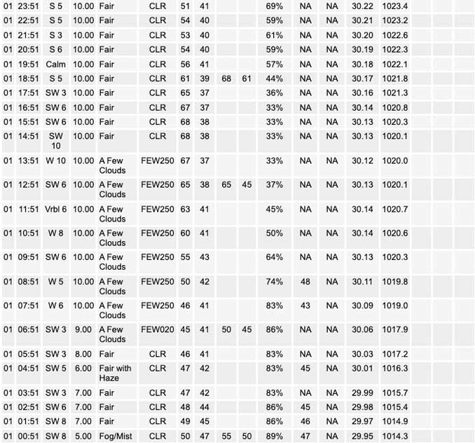
A stout mid-level ridge continues to reside across the Ohio River Valley and Mid-Atlantic region which is helping to keep temperatures on a mild note to start November. High temperatures today are expected to top out in the upper 60s to around 70 degrees before gradually cooling into the low to mid-40s overnight. The combination of clear skies, light winds, and sufficient low level moisture will allow fog to develop across parts of northeastern Illinois and northwest Indiana once again tonight into Wednesday morning. Guidance has continued to indicate that most of the area would see at least some patchy fog tonight with the best coverage continuing to be for areas along and east of I-55, but some uncertainty remains on how dense the fog will become. Forecast soundings have continued to show some elevated winds just above the surface which may allow for some drier air to get mixed in and keep the fog more shallow in nature with pockets of dense fog in spots. Given this uncertainty I have maintained the majority of the going fog coverage, but did expand the patchy fog mention north towards the Rockford area to better align with guidance.
Once the fog burns off Wednesday morning another sunny and mild day is on tap with high temperatures expected to be in the upper 60s and lower 70s. However, cloud cover will begin to increase Wednesday afternoon as better moisture returns. Winds will also be increasing in speed Wednesday evening into Thursday morning with occasional gusts in the low to mid teens possible.
Yack/NWS Chicago
Area Forecast Discussion
National Weather Service Chicago/Romeoville, IL
1212 PM CDT Tue Nov 1 2022
.SHORT TERM…
Issued at 330 AM CDT Tue Nov 1 2022
Through Wednesday…
Main forecast concern in the short term period is lingering fog early this morning mainly east of I-55 across the south/southeast burbs, east central IL and northwest IN. Dense fog advisory has been issued through 10 AM. Some fog potential exists again later tonight for generally the same areas, but otherwise dry and very mild weather is expected to kick off the month of November.
Early morning surface analysis depicts 1012 mb low pressure pulling slowly away from the area over Lake Huron, with a weak cold front trailing through eastern IN. Very moist low-level air lingers behind the front however, with 45-50 degree surface dew points extending west into the I-55 corridor over central and eastern IL. Low stratus associated with the departing system has cleared out for the most part across these areas overnight, and combined with wet ground from earlier rains and light/calm winds has allowed fog to develop and become locally dense. Winds above the boundary layer have increased since last evening per recent AMDAR aircraft descent sounding from MDW (around 12 kts around 250 feet AGL at about 145 AM), and this has helped to mix down slightly drier air across parts of northern IL since late evening. However, dense fog continues to be reported east of the I-55 corridor as of 3 AM, and was expanding in some spots where stratus had more recently cleared out. Based on this had earlier extended/expanded dense fog advisory headlines east of I-55 through 10 AM this morning. Somewhat low confidence in trends especially beyond sunrise given aforementioned winds just above the near-surface inversion, though pockets of dense fog (0SM to 1/4SM in spots) will affect early commuters.
Otherwise, mid-level short wave ridging will develop across the area this morning in the wake of yesterday`s departing upper trough. After any lingering morning fog/stratus burns off, sunny skies are expected with light southwest winds and modest but persistent low level warm advection expected to result in temperatures warming to the mid-60s in the east, and near 70 across the western cwa. These temperatures are roughly 9-15 degrees above our normals for November first. Light south winds persist tonight, helping to keep temps up in the low 40s in most spots, though with a few upper 30s not out of the question in our typical cool spots and mid-40s in the more urban core of Chicago. Somewhat lighter winds and a bit of lingering low level moisture may again produce some patchy fog tonight/early Wednesday in similar locations to this morning. Wednesday looks like a repeat of today, but 1-3 degrees warmer and with slightly stronger 10-15 mph south winds.
Ratzer
