
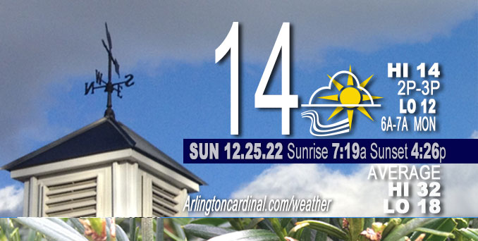
Sunday Hi 14, clear, increasing clouds after 1p, winds W to SW, 14 to 7 MPH, G22 to 18 to 13 MPH, until 12a Monday
NWS CHGO | NWS HRLY | /NWSchicago | 🌡
ARLINGTON HEIGHTS WEATHER
▴ forecast7 (Arl. Hts.) | RADAR | WIDE RADAR
⏪ Hrly Data Table | Hrly Future Graph ⏩
IMPORTANT NOTE ON NWS DATA
⏪ Hrly Data Table | Hrly Future Graph ⏩
======================
Sunday and Sunday Night …
Weather Hazards expected…
Elevated Snow Risk.
Wind Chill Advisory issued Saturday December 24, 2022 at 1:05 p.m. expired at 10:00 a.m. Sunday, December 25, 2022.
DISCUSSION…
A period of snow is expected overnight Sunday night to Monday morning which may lead to slick spots on roadways.
A quick moving clipper system will move into the area Sunday evening and bring with it the chance for accumulating snow — possibly 1.0 inch from 10:00 p.m. Sunday until 10:00 a.m. Monday. Currently the system is centered over the US-Canadian border but will be moving across the northern Plains this afternoon and then through the central Mississippi Valley late this evening into the day on Monday.
Hello mobile users! If you encounter a mobile “unfriendly” weather page, turn your phone sideways for a better view.
======================
O’HARE FORECAST …
Forecast Beginning Sunday, Dec. 25, 2022
Christmas Day: Sunny, with a high near 14. Wind chill values as low as -7. West wind 10 to 15 mph, with gusts as high as 20 mph.
Christmas Night: Snow likely, mainly after 2am. Mostly cloudy, with a steady temperature around 13. Wind chill values as low as -1. West southwest wind 5 to 10 mph becoming south after midnight. Winds could gust as high as 15 mph. Chance of precipitation is 60%. New snow accumulation of less than one inch possible.
Monday: Snow likely, mainly before 11am. Cloudy, then gradually becoming mostly sunny, with a high near 20. Calm wind becoming northwest around 5 mph in the afternoon. Chance of precipitation is 60%. New snow accumulation of less than a half inch possible.
Monday Night: Partly cloudy, with a low around 8. Wind chill values as low as -2. West northwest wind around 5 mph, with gusts as high as 10 mph.
Tuesday: Partly sunny, with a high near 26. South southwest wind 5 to 15 mph, with gusts as high as 20 mph.
Tuesday Night: Mostly cloudy, with a low around 22.
Wednesday: Partly sunny, with a high near 41.
Wednesday Night: Mostly cloudy, with a low around 35.
Thursday: Cloudy, with a high near 49.
Thursday Night: A chance of rain. Cloudy, with a low around 43.
Friday: Rain likely. Cloudy, with a high near 52.
Friday Night: Rain likely. Cloudy, with a low around 43.
Saturday: Rain likely. Cloudy, with a high near 50.


CHICAGOWEATHERSTATION.COM

ChicagoWeatherStation.com I O’Hare Normal Temps/Precip I O’Hare Record Temps, Precip, Snow
LIVE RADAR | STORM TRACKS | UNISYS US IR SAT | UNISYS Midwest IR SAT | UNISYS More IR SAT
WunderMap® with Temperature/Wind Data || Google: Arlington Heights Area Temps | US TEMPS
Full Screen Motion Weather Radar (Wunderground.com)
Midwest Cloud Cover with Arlington Heights Weather Forecast
ChicagoWeatherStation.com I O’Hare Normal Temps/Precip I O’Hare Record Temps, Precip, Snow
SUNLIGHT DATA FOR SECURITY, TRAFFIC SAFETY, AND SPORTS
SunCalc.net data with solar azimuth and trajectory, times for dawn, sunrise, solar noon, sunset, dusk …
NIGHT SKY THIS MONTH …
Backyard stargazers get a monthly guide to the northern hemisphere’s skywatching events with “Tonight’s Sky.” Check the night sky objects for this month and past months in the playlist from the Space Telescope Science Institute YouTube channel (Musical track The Far River written by Jonn Serrie, from the album And the Stars Go With You courtesy of New World Music Ltd).
Get updates from The Cardinal ALL NEWS FEEDS on Facebook. Just ‘LIKE’ the ‘Arlington Cardinal Page (become a fan of our page). The updates cover all posts and sub-category posts from The Cardinal — Arlingtoncardinal.com. You can also limit feeds to specific categories. See all of The Cardinal Facebook fan pages at Arlingtoncardinal.com/about/facebook …
Help fund The Cardinal Arlingtoncardinal.com/sponsor
Area Forecast Discussion
National Weather Service Chicago/Romeoville, IL
1124 AM CST Sun Dec 25 2022
.SHORT TERM… Issued at 250 AM CST Sun Dec 25 2022
Through Monday…
Key forecast concerns for the short term… *Westerly winds will continue to gradually ease through today
*Combination of cold temperatures and lingering winds will create wind chills around -20 degrees this morning, but expected to improve by this afternoon
*Quick moving clipper system moves through this evening into Monday morning bringing another round of accumulating snow, slippery travel also looks possible during the Monday morning commute
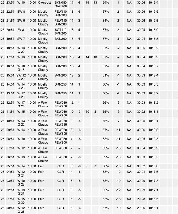
A silent night is underway with the exception of the lingering gusty winds that continue to gust upwards of 30 mph this morning. Winds will continue to ease through our Christmas holiday as the upper- level trough continues to move away and the pressure gradient at the surface eases. However, gusts of 20 to 25 mph are expected through this afternoon before we completely lose the gusts this evening. Temperatures will start off on the frigid side of things this morning with values in the low single digits with a couple spots possibly flirting with single digits below zero. This will generate wind chills around -20 degrees this morning which could lead to frostbite in as little as 30 minutes, so be sure to bundle up if heading out. Temperatures will be warming into the lower teens this afternoon under mostly sunny skies which should brighten the holiday spirit.
Unfortunately the sunny weather won`t last long as a quick moving clipper system will move into the area this evening and bring with it the chance for accumulating snow. Currently the system is centered over the US-Canadian border but will be moving across the northern Plains this afternoon and then through the central Mississippi Valley late this evening into the day on Monday. Guidance has continued to show that this system would be capable of producing accumulating snow given the existing cold ground conditions, but there continues to be some uncertainty in the exact track of the surface low and therefore where the highest snow amounts will fall. The general consensus in both deterministic and ensemble guidance is that the low would track into central Illinois which would keep the highest snowfall totals closer to the I-39 corridor where better moisture looks to reside ahead of the system. However, widespread snow accumulation of at least half an inch continues to look likely for northeastern Illinois and northwest Indiana with higher totals upwards of an inch or so near the I-39 corridor. While these accumulations are expected to be minor, the aforementioned cold ground should allow for snow to accumulate quickly on roads and bridges which will make for slippery travel conditions for the Monday morning commute. A Winter Weather Advisory was considered for this potential, but decided to hold off for now given the marginal snowfall amounts expected. Regardless, those with plans to travel Monday morning should exercise caution and add extra time to reach your destination.
Snow is expected to come to an end Monday morning as the system will be south of our area and be moving eastward. However, as the upper- level shortwave rotates through the area on Monday an area of surface convergence is expected to develop over the southern portion of Lake Michigan which will act as a forcing mechanism for lake effect snow to continue into Monday evening. While guidance is in decent agreement on this convergent axis developing there is uncertainty in the exact location and therefore where the lake effect will impact. For now I have taken the consensus approach and maintained snow chances Monday afternoon for areas near the Illinois- Indiana state line and northwestern Indiana where the majority of guidance has the axis. In terms of snow amounts, minor accumulations are expected with totals of a few tenths to half an inch expected. While minor these accumulations will prolong the slippery travel conditions until the convergence axis shifts into southwestern Michigan Monday evening.
Yack/NWS Chicago
