
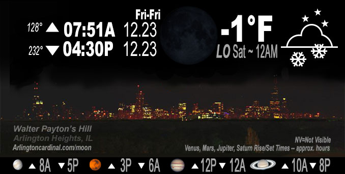
🌑 🌓 🌕 🌗 New Moon, light snow, sky cover overnight Fri. to Sat. 84% to 72%, winds W to WNW, 25 MPH, G45 to 36 MPH, Low -1, 12a to 4a
NWS CHGO | NWS HRLY | /NWSchicago | 🌡
ARLINGTON HEIGHTS WEATHER
▴ forecast7 (Arl. Hts.) | RADAR | WIDE RADAR
IMPORTANT NOTE ON NWS DATA
======================
Overnight Friday/Saturday …
Weather Hazards expected…
Extreme Excessive Cold Risk.
Elevated Non Thunderstorm Wind Risk.
Significant Blowing Snow Risk.
Limited Ice Jam Flooding Risk.
DISCUSSION…
Dangerous travel conditions are expected to continue through tonight due to a combination of falling snow, blowing snow, and bitterly cold temperatures. Near-blizzard conditions are possible today and tonight, especially in open areas. Conditions may become life-threatening for anyone who becomes stranded. These cold temperatures may also lead to ice jams on area rivers which could cause flooding.
Very strong winds risking tree damage and power outages will decline into the 30 MPH. Dangerously low wind chills will continue in the range of -28°F to -24°F.
Hello mobile users! If you encounter mobile “unfriendly” weather page, turn your phone sideways for a better view.
======================
O’HARE FORECAST …
Forecast Beginning Friday Night, Dec. 23, 2022 …
Friday Night: Isolated snow showers before midnight, then scattered flurries after midnight. Widespread blowing snow. Mostly cloudy, with a low around -2. Wind chill values as low as -27. Breezy, with a west wind 20 to 25 mph, with gusts as high as 45 mph. Chance of precipitation is 20%.
Saturday: A chance of flurries. Areas of blowing snow. Partly sunny and cold, with a high near 8. Wind chill values as low as -24. Breezy, with a west wind around 20 mph, with gusts as high as 40 mph.
Saturday Night: Mostly cloudy, with a low around 2. Wind chill values as low as -15. Breezy, with a west northwest wind 15 to 20 mph, with gusts as high as 35 mph.
Christmas Day: Mostly sunny, with a high near 13. West wind 10 to 15 mph, with gusts as high as 20 mph.
Sunday Night: A 40 percent chance of snow after midnight. Mostly cloudy, with a low around 7.
Monday: A 40 percent chance of snow before noon. Mostly cloudy, with a high near 20.
Monday Night: Mostly cloudy, with a low around 8.
Tuesday: Partly sunny, with a high near 25.
Tuesday Night: Mostly cloudy, with a low around 20.
Wednesday: Mostly cloudy, with a high near 41.
Wednesday Night: A chance of rain. Cloudy, with a low around 35.
Thursday: A chance of rain. Cloudy, with a high near 47.
O’Hare forecast archive and hourly weather observations archive are available HERE on the CARDINAL NEWS Magazine.
Arlingtoncardinal.com/moonphases
Arlingtoncardinal.com/nightsky
NIGHT SKY THIS MONTH …
Check the night sky objects for this month and past months in the playlist from the Space Telescope Science Institute YouTube channel Backyard stargazers get a monthly guide to the northern hemisphere’s skywatching events with “Tonight’s Sky” (Musical track The Far River written by Jonn Serrie, from the album And the Stars Go With You courtesy of New World Music Ltd. Musical track The Far River written by Jonn Serrie, from the album And the Stars Go With You courtesy of New World Music Ltd).
Telephoto lens, ISO 100, f/11, Shutter Speed 1/100 to 1/125 for the Moon.
Get updates from The Cardinal ALL NEWS FEEDS on Facebook. Just ‘LIKE’ the ‘Arlington Cardinal Page (become a fan of our page). The updates cover all posts and sub-category posts from The Cardinal — Arlingtoncardinal.com. You can also limit feeds to specific categories. See all of The Cardinal Facebook fan pages at Arlingtoncardinal.com/about/facebook …
Help fund The Cardinal Arlingtoncardinal.com/sponsor
Telephoto lens, ISO 1600, f/11, Shutter Speed 2.5″ for the skyline. The skyline exposure was toned down, and brightness and contrast was adjusted in Photoshop.
Area Forecast Discussion
National Weather Service Chicago/Romeoville, IL
1103 PM CST Fri Dec 23 2022
.SHORT TERM… Issued at 134 PM CST Fri Dec 23 2022
Through Saturday…
National satellite imagery paints an impressive winter scene with deep cyclonic flow across the eastern 2/3 of the United States, a mature surface low pressure system along the Ontario/Quebec borders, an expansive snow pack as far south as the the I-40 corridor, and cold-air advection-driven stratocumulus clouds screaming south across the Gulf of Mexico. The Great Lakes are firmly within the grip of the arctic airmass at press time as evident by temperatures at or below 0F and wind chills ranging from 25 to 35F below zero. Westerly winds at times gusting 45-50 mph (and even 60 mph as recently reported at Gary Airport) continue to lead to considerable blowing snow in open and rural areas, including outside our window where visibility has dropped below 1000 feet from time to time. Numerous interstate closures continue this afternoon primarily in northwestern Indiana due to blowing snow and, in the case of northeastern Porter County, bonafide blizzard conditions. Taken altogether, it`s a raw and uncomfortably cold day.
High resolution model guidance (most notably the RAP/NAM3) continue to suggest a lingering vort max along the backside of the cyclonic flow aloft will swing across northern IL and northwestern IN this evening. As a result, low-level saturation will build back into the base of the DGZ supporting an expansion of scattered if not numerous snow showers primarily along and east of Interstate 39 from 8 PM to 2 AM. Considering westerly winds will remain strong, stark visibility restrictions will continue in and around any snow shower with no meaningful (or frankly measurable by virtue of the wind) accumulations expected. Another cold night is in store with overnight lows a few degrees below 0F (wind chills of 25 to 30 below zero).
Even as the upper-level cyclonic flow gradually shifts eastward, tomorrow will offer a continuation of raw and cold conditions with wind gusts of 30 to 40 mph and temperatures of +2 to +10F giving way to wind chills of -15 to -20F. Areas of blowing snow will continue particularly in open and rural areas, though many areas should see pokes of the sun.
One last note – we will continue the current winter headlines (Winter Storm/Blizzard Warnings) until 6 AM Saturday for continued dangerously low wind chills, blustery westerly winds, and areas of blowing snow.
Borchardt/NWS Chicago
