
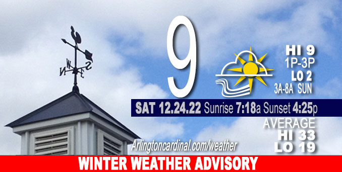
Saturday Hi 9, partly sunny, winds W to WNW, 22 to 17 MPH, G36 to 38 to 28 MPH, continuing Sunday
NWS CHGO | NWS HRLY | /NWSchicago | 🌡
ARLINGTON HEIGHTS WEATHER
▴ forecast7 (Arl. Hts.) | RADAR | WIDE RADAR
⏪ Hrly Data Table | Hrly Future Graph ⏩
IMPORTANT NOTE ON NWS DATA
⏪ Hrly Data Table | Hrly Future Graph ⏩
======================
Saturday and Saturday Night …
Weather Hazards expected…
Extreme Excessive Cold Risk.
Elevated Non Thunderstorm Wind Risk.
Elevated Blowing Snow Risk.
Limited Ice Jam Flooding Risk.
WINTER STORM WARNING expired at 6:00 a.m. Saturday, December 24, 2022.
Low -1°F Saturday morning from 12am to 4am with a high of 9°F Saturday from 1pm to 3pm.
Low 2°F Sunday morning from 3am to 7am with a high 12°F Sunday 3pm to 4pm.
Low 9°F Monday 12am to 3am with a high of 21°F Monday at 1pm to 4pm.
DISCUSSION…
Strong winds and bitterly cold temperatures will result in dangerously cold wind chills, especially Saturday morning. The strong winds will also result in blowing and drifting snow, especially in open areas Saturday morning. Wind Chills in the -20s to a high of -10°F around 1pm to 3pm during the Chicago Bears game with the Buffalo Bills on Saturday (Christmas Eve).
Hello mobile users! If you encounter a mobile “unfriendly” weather page, turn your phone sideways for a better view.
======================
O’HARE FORECAST …
Forecast Beginning Saturday, Dec. 24, 2022
Saturday: Patchy blowing snow before noon. Partly sunny and cold, with a high near 9. Wind chill values as low as -21. Breezy, with a west wind around 20 mph, with gusts as high as 40 mph.
Saturday: Partly cloudy, with a low around 2. Wind chill values as low as -17. Breezy, with a west wind 15 to 20 mph, with gusts as high as 35 mph.
Christmas Day: Mostly sunny, with a high near 12. Wind chill values as low as -16. West wind 10 to 15 mph, with gusts as high as 25 mph.
Sunday Night: Snow likely after midnight. Mostly cloudy, with a low around 9. Wind chill values as low as -4. Southwest wind 5 to 10 mph, with gusts as high as 15 mph. Chance of precipitation is 60%. New snow accumulation of less than one inch possible.
Monday: A 50 percent chance of snow before noon. Mostly cloudy, with a high near 22. South wind around 5 mph becoming north northwest in the afternoon. Winds could gust as high as 10 mph.
Monday Night: Mostly cloudy, with a low around 7.
Tuesday: Partly sunny, with a high near 24.
Tuesday Night: Mostly cloudy, with a low around 22.
Wednesday: Mostly cloudy, with a high near 41.
Wednesday Night: Cloudy, with a low around 36.
Thursday: A chance of rain. Cloudy, with a high near 50.
Thursday Night: A chance of rain. Cloudy, with a low around 40.
Friday: A chance of rain. Cloudy, with a high near 47.
WINTER WEATHER ADVISORY …
Winter Weather Advisory
URGENT – WINTER WEATHER MESSAGE
National Weather Service Chicago IL
615 AM CST Sat Dec 24 2022COUNTIES: Winnebago-Boone-McHenry-Lake IL-Ogle-Lee-De Kalb-Kane-DuPage- La Salle-Kendall-Grundy-Kankakee-Livingston-Iroquois-Ford- Northern Cook-Central Cook-Southern Cook-Northern Will- Southern Will-Eastern Will
MUNICIPALITIES: Arlington Heights, Rockford, Belvidere, Crystal Lake, Algonquin, McHenry, Woodstock, Waukegan, Buffalo Grove, Mundelein, Gurnee, Rochelle, Oregon, Byron, Dixon, DeKalb, Sycamore, Aurora, Elgin, Naperville, Wheaton, Downers Grove, Lombard, Carol Stream, Ottawa, Streator, La Salle, Mendota, Marseilles, Oswego, Yorkville, Plano, Morris, Coal City, Minooka, Kankakee, Bourbonnais, Bradley, Pontiac, Dwight, Fairbury, Watseka, Gilman, Paxton, Gibson City, Evanston, Des Plaines, Schaumburg, Palatine, Northbrook, Chicago, Cicero, Oak Lawn, Oak Park, La Grange, Calumet City, Oak Forest, Lemont, Orland Park, Park Forest, Joliet, Bolingbrook, Plainfield, Mokena, Channahon, Manhattan, Wilmington, Crete, Peotone, and Beecher 615 AM CST Sat Dec 24 2022
…WINTER WEATHER ADVISORY REMAINS IN EFFECT UNTIL NOON CST TODAY…
* WHAT…Blowing and drifting snow, reduced visibilities in open areas, wind gusts to 35 mph, and wind chills of 20 to 30 below zero are expected.
* WHERE…Portions of northern and central Illinois.
* WHEN…Until noon CST today.
* IMPACTS…Areas of blowing snow could reduce visibility. The cold wind chills could cause frostbite on exposed skin in as little as 30 minutes.
PRECAUTIONARY/PREPAREDNESS ACTIONS…
Use caution while traveling, especially in open areas.
The latest road conditions for Illinois can be obtained on the internet at www.gettingaroundillinois.com.


CHICAGOWEATHERSTATION.COM

ChicagoWeatherStation.com I O’Hare Normal Temps/Precip I O’Hare Record Temps, Precip, Snow
LIVE RADAR | STORM TRACKS | UNISYS US IR SAT | UNISYS Midwest IR SAT | UNISYS More IR SAT
WunderMap® with Temperature/Wind Data || Google: Arlington Heights Area Temps | US TEMPS
Full Screen Motion Weather Radar (Wunderground.com)
Midwest Cloud Cover with Arlington Heights Weather Forecast
ChicagoWeatherStation.com I O’Hare Normal Temps/Precip I O’Hare Record Temps, Precip, Snow
SUNLIGHT DATA FOR SECURITY, TRAFFIC SAFETY, AND SPORTS
SunCalc.net data with solar azimuth and trajectory, times for dawn, sunrise, solar noon, sunset, dusk …
NIGHT SKY THIS MONTH …
Backyard stargazers get a monthly guide to the northern hemisphere’s skywatching events with “Tonight’s Sky.” Check the night sky objects for this month and past months in the playlist from the Space Telescope Science Institute YouTube channel (Musical track The Far River written by Jonn Serrie, from the album And the Stars Go With You courtesy of New World Music Ltd).
Get updates from The Cardinal ALL NEWS FEEDS on Facebook. Just ‘LIKE’ the ‘Arlington Cardinal Page (become a fan of our page). The updates cover all posts and sub-category posts from The Cardinal — Arlingtoncardinal.com. You can also limit feeds to specific categories. See all of The Cardinal Facebook fan pages at Arlingtoncardinal.com/about/facebook …
Help fund The Cardinal Arlingtoncardinal.com/sponsor
Area Forecast Discussion
National Weather Service Chicago/Romeoville, IL
532 AM CST Sat Dec 24 2022
.SHORT TERM… Issued at 252 AM CST Sat Dec 24 2022
Through Sunday…
Key forecast concerns through Christmas… *Gusty winds upwards of 40 mph to persist through this evening before gradually easing heading into Sunday
*Bitter cold continues through Christmas day with wind chills in the -20 to -25 degree range
*Blowing and drifting snow will continue to be a concern until winds ease
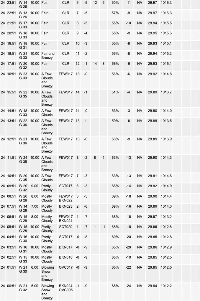
The area of light snow showers that developed in association with a quick moving vorticity maxima aloft have moved out over the open waters of Lake Michigan and weakened over the past couple of hours. This has left the area under cloudy, but precipitation free skies this morning which is expected to continue through our Saturday. However, recent aircraft and forecast soundings are showing a nearly 600 mb deep saturated layer that may be able to spit out a brief flurry or two through daybreak until drier air begins to filter in aloft. No accumulation is expected from any flurries that are realized.
The main forecast concerns for our Saturday will be the prevailing gusty winds and bitter cold. While wind gusts have come down from what we experienced on Friday, gusts around 35 mph continue to be observed across northeastern Illinois and northwest Indiana this morning and are expected to continue through this evening. Hi- resolution forecast guidance continues to indicate that a strong 40 to 50 kt low level jet resides over the northern Mississippi River Valley and Great Lakes regions which is expected to gradually move eastward with the upper trough later today. In the mean time forecast soundings show that the atmosphere would be able to ta Pinto some of these stronger winds aloft which will create widespread 35 to 40 mph wind gusts with the potential for higher gusts to 45 mph periodically. These winds will still have the potential to create blowing and drifting snow through this evening which will lead to slowed travel at times especially on rural north-south oriented roads. If planning to travel be sure to add extra time and use caution if you encounter blowing snow. Winds will gradually begin to ease overnight tonight but will still produce breezy 20 to 25 mph gusts through the day on Sunday.
In addition to the winds, bitter temperatures are expected to persist through our Christmas weekend. Highs today will be warmer than what was experienced on Friday, but temperatures will still remain in the positive single digits this afternoon. Wind chills will start off in the -20 to -30 range this morning and gradually increase to the -15 to -20 range this afternoon as temperatures warm. Wind chills of this magnitude are still capable of causing frost bite on exposed skin in under 30 minutes so be sure to bundle up if before heading out today. Temperatures will remain cold through Christmas on Sunday with temperatures starting off near zero Sunday morning with wind chills around -20 and warming into the lower teens by the afternoon. On the bright side, skies are expected to begin to clear out heading into Sunday morning so at least we will get to see some sun.
Lastly, to account for the aforementioned blowing snow and wind chills for today the Winter Storm warning has been extended through noon today for our northwestern Indiana counties where traffic maps continue to show poor road conditions. As for our northeastern Illinois counties, a Winter Weather Advisory has been issued to account for the lingering blowing snow and wind chill threat until noon today.
Yack/NWS Chicago
