
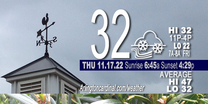
THURSDAY Hi 32, mostly cloudy slight clearing after 4p, snow showers, winds SW to W, 14 to 15 to 14 MPH, G21 to 24 to 20 MPH
NWS CHGO | NWS HRLY | /NWSchicago | 🌡
ARLINGTON HEIGHTS WEATHER
▴ forecast7 (Arl. Hts.) | RADAR | WIDE RADAR
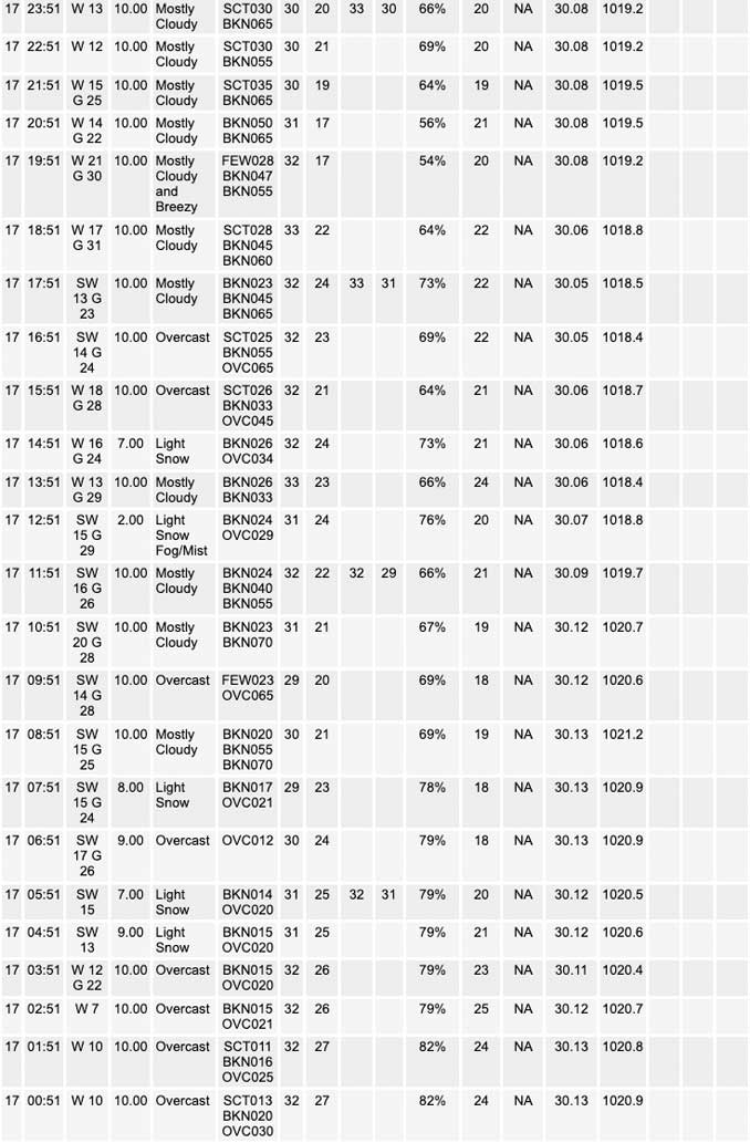
⏪ Hrly Data Table | Hrly Future Graph ⏩
IMPORTANT NOTE ON NWS DATA
⏪ Hrly Data Table | Hrly Future Graph ⏩
======================
Thursday and Thursday Night …
Weather hazards expected…
This Hazardous Weather Outlook is for portions of North Central
Illinois…Northeast Illinois and Northwest Indiana.
Limited Snow Risk.
Potential for isolated to scattered snow showers (possibly a few more robust squalls with 30+ mph wind gusts) mainly later afternoon and into the evening. Some snow showers will once again result in sharp visibility reductions and quick spotty dustings.
– Breezy Thursday with wind chills generally in the teens to near 20 degrees.
– Push of colder air arrives on Friday. Highs only in the mid and upper 20s. Low wind chill down to single digits (8 degrees) Friday at 7 AM. High wind chill only reach the lower to mid-teens (15 degrees) from 10 AM to 4 PM.
DISCUSSION…
Scattered snow showers will develop Friday afternoon and linger into the evening. A few of these may produce brief bursts of snow with wind gusts up to 35 mph, resulting in rapidly-changing visibilities and patchy coatings on elevated surfaces.
======================
O’HARE FORECAST …
Forecast Beginning Thursday, Nov. 17, 2022
Thursday: Scattered flurries before 1pm, then scattered snow showers, mainly after 2pm. Cloudy, with a high near 32. West southwest wind around 15 mph, with gusts as high as 25 mph. Chance of precipitation is 40%.
Thursday Night: Isolated snow showers before midnight, then scattered flurries after midnight. Mostly cloudy, with a low around 22. West wind around 15 mph, with gusts as high as 25 mph. Chance of precipitation is 20%.
Friday: Scattered flurries after noon. Mostly cloudy, with a high near 27. West wind around 15 mph, with gusts as high as 25 mph.
Friday Night: Mostly cloudy, with a low around 17. West southwest wind around 15 mph, with gusts as high as 20 mph.
Saturday: A chance of flurries before noon, then a slight chance of snow showers after noon. Mostly cloudy, with a high near 29. Breezy, with a west wind 15 to 20 mph, with gusts as high as 30 mph. Chance of precipitation is 20%.
Saturday Night: Partly cloudy, with a low around 12.
Sunday: Sunny, with a high near 32.
Sunday Night: Partly cloudy, with a low around 26.
Monday: Sunny, with a high near 42.
Monday Night: Mostly clear, with a low around 28.
Tuesday: Mostly sunny, with a high near 48.
Tuesday Night: Partly cloudy, with a low around 33.
Wednesday: Partly sunny, with a high near 46.


CHICAGOWEATHERSTATION.COM

ChicagoWeatherStation.com I O’Hare Normal Temps/Precip I O’Hare Record Temps, Precip, Snow
LIVE RADAR | STORM TRACKS | UNISYS US IR SAT | UNISYS Midwest IR SAT | UNISYS More IR SAT
WunderMap® with Temperature/Wind Data || Google: Arlington Heights Area Temps | US TEMPS
Full Screen Motion Weather Radar (Wunderground.com)
Midwest Cloud Cover with Arlington Heights Weather Forecast
ChicagoWeatherStation.com I O’Hare Normal Temps/Precip I O’Hare Record Temps, Precip, Snow
SUNLIGHT DATA FOR SECURITY, TRAFFIC SAFETY, AND SPORTS
SunCalc.net data with solar azimuth and trajectory, times for dawn, sunrise, solar noon, sunset, dusk …
NIGHT SKY THIS MONTH …
Backyard stargazers get a monthly guide to the northern hemisphere’s skywatching events with “Tonight’s Sky.” Check the night sky objects for this month and past months in the playlist from the Space Telescope Science Institute YouTube channel (Musical track The Far River written by Jonn Serrie, from the album And the Stars Go With You courtesy of New World Music Ltd).
Get updates from The Cardinal ALL NEWS FEEDS on Facebook. Just ‘LIKE’ the ‘Arlington Cardinal Page (become a fan of our page). The updates cover all posts and sub-category posts from The Cardinal — Arlingtoncardinal.com. You can also limit feeds to specific categories. See all of The Cardinal Facebook fan pages at Arlingtoncardinal.com/about/facebook …
Help fund The Cardinal Arlingtoncardinal.com/sponsor
Area Forecast Discussion
National Weather Service Chicago/Romeoville, IL
524 AM CST Thu Nov 17 2022
.UPDATE… Issued at 520 AM CST Thu Nov 17 2022
Issued a quick little update to add a very brief mention of freezing drizzle to the grids south of I-80 for the next 2-3 hours. Light radar returns (-5 to 0 dBz) are associated with very light precipitation and a lead shortwave to our north. Have noted several sites reporting rain or UP south of I-80, and this is where soundings indicate more marginal saturation (really only u Pto about -9 C), driving at least ephemeral losses of cloud ice. Kankakee webcams do show some flakes in there, so it`s likely this is just a true “snizzle” (snow and drizzle) instead of completely drizzle. Given the very light and brief nature of this precipitation (and likely not 100 percent freezing drizzle), don`t envision travel impacts this morning, but will continue to keep a close eye on things.
Carlaw
&&
.SHORT TERM… Issued at 141 AM CST Thu Nov 17 2022
Through Friday…
Key Messages:
– Potential for isolated to scattered snow showers (possibly a few more robust squalls with 30+ mph wind gusts) mainly later afternoon and into the evening. Some will once again result in sharp visibility reductions and quick spotty dustings.
– Breezy today with wind chills generally in the teens to near 20 degrees.
– Push of colder air arrives on Friday. Highs only in the mid and upper 20s.
Shallow saturation beneath the DGZ and lingering weak low-level ascent associated with a nearby shortwave is helping to squeeze out spotty flurries to our west, and this will continue to expand eastward through the morning. Forecast soundings show we`re on the cusp of losing cloud ice, and while we`ve seen a few automated reports of “unknown precipitation” and BR, majority of obs remain snow, and IR cloud top temps appear cold enough to maintain heterogeneous nucleation as this activity spreads eastward. We`ll continue to keep an eye on observations, but it looks like the freezing drizzle threat is pretty low.
Flurries/light snow showers will continue intermittently this morning. By this afternoon, we should start to see a gradual uptick in convective showers as a robust sheared vort max (currently across South Dakota) sweeps across northern Illinois. Moisture depth/quality is not as high as yesterday, but boundary layer winds are stronger (notably so). There does seem to be a trend towards deeper saturation, however, and given the magnitude of incoming forcing, ended up expanding snow shower chances across the entire forecast area this afternoon. Coverage should generally peak around “scattered” north of I-80, so the inherited PoPs from the dayshift still look good. Patchy dustings seem like a good bet this afternoon and evening, especially with temperatures a degree or two colder than yesterday, and with the stronger winds today, sharp visibility reductions, perhaps briefly to a quarter mile, are plausible within the most robust convective elements.
The parameter space today is favorable for bonafide squalls given the much more robust boundary layer flow (about 25 to 30 kts). Given the slightly better progged moisture, do think the potential for a few heavier squalls with 30-40 mph wind gusts exists, mainly in the 3 to 7 PM timeframe as the bulk of the large scale forcing arrives.
A series of trailing shortwaves will continue well into the evening and overnight and as such, will likely keep snow showers going through the night, mainly south of I-80. Otherwise, the main story will be the the arrival of a notably colder airmass on Friday with wind chills in the single digits and teens for many Friday afternoon.
Carlaw/NWS Chicago
