
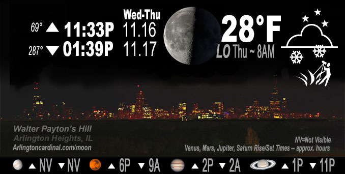
🌗 🌑 🌓 🌕 Last Quarter Moon, sky cover overnight Wed. to Thu. 96% to 63% to 89%, winds NW to W to WSW, 10 to 8 MPH, Low 28, 8a to 9a
NWS CHGO | NWS HRLY | /NWSchicago | 🌡
ARLINGTON HEIGHTS WEATHER
▴ forecast7 (Arl. Hts.) | RADAR | WIDE RADAR
IMPORTANT NOTE ON NWS DATA
======================
Wednesday and Wednesday Night …
Weather hazards expected…
Limited Snow Risk Wednesday and Thursday.
Limited Excessive Cold Risk Saturday Night/Sunday Morning
DISCUSSION…
Snow showers forecast to develop Wednesday morning and afternoon. Some snow showers will produce brief bursts of heavy snow resulting in sharply reduced visibilities. While main roads are expected to remain wet, patchy slick spots and quick coatings are possible on elevated and grassy surfaces. Snow showers will diminish in coverage through the evening.
Lake effect snow is expected across parts of northwest Indiana. Uncertainty in the placement of this band continues, but the potential for a several inches of slushy accumulations exists this afternoon and evening across far northeastern portions of Porter County.
Hello mobile users! If you encounter mobile “unfriendly” weather page, turn your phone sideways for a better view.
======================
O’HARE FORECAST …
Forecast Beginning Wednesday Night, Nov. 16, 2022
Wednesday Night: Isolated snow showers before 9pm, then scattered flurries after 9pm. Mostly cloudy, with a low around 28. West wind around 10 mph. Chance of precipitation is 20%.
Thursday: A chance of flurries before noon, then a chance of snow showers, mainly after 3pm. Cloudy, with a high near 34. West southwest wind 10 to 15 mph, with gusts as high as 25 mph. Chance of precipitation is 30%.
Thursday Night: A 20 percent chance of snow before midnight. Mostly cloudy, with a low around 20. West wind around 15 mph, with gusts as high as 20 mph.
Friday: Mostly cloudy, with a high near 27.
Friday Night: Mostly cloudy, with a low around 16.
Saturday: Mostly cloudy, with a high near 29.
Saturday Night: Mostly cloudy, with a low around 12.
Sunday: Sunny, with a high near 25.
Sunday Night: Partly cloudy, with a low around 19.
Monday: Sunny, with a high near 39.
Monday Night: Mostly clear, with a low around 25.
Tuesday: Mostly sunny, with a high near 42.
O’Hare forecast archive and hourly weather observations archive are available HERE on the CARDINAL NEWS Magazine.
Arlingtoncardinal.com/moonphases
Arlingtoncardinal.com/nightsky
NIGHT SKY THIS MONTH …
Check the night sky objects for this month and past months in the playlist from the Space Telescope Science Institute YouTube channel Backyard stargazers get a monthly guide to the northern hemisphere’s skywatching events with “Tonight’s Sky” (Musical track The Far River written by Jonn Serrie, from the album And the Stars Go With You courtesy of New World Music Ltd. Musical track The Far River written by Jonn Serrie, from the album And the Stars Go With You courtesy of New World Music Ltd).
Telephoto lens, ISO 100, f/11, Shutter Speed 1/100 to 1/125 for the Moon.
Get updates from The Cardinal ALL NEWS FEEDS on Facebook. Just ‘LIKE’ the ‘Arlington Cardinal Page (become a fan of our page). The updates cover all posts and sub-category posts from The Cardinal — Arlingtoncardinal.com. You can also limit feeds to specific categories. See all of The Cardinal Facebook fan pages at Arlingtoncardinal.com/about/facebook …
Help fund The Cardinal Arlingtoncardinal.com/sponsor
Telephoto lens, ISO 1600, f/11, Shutter Speed 2.5″ for the skyline. The skyline exposure was toned down, and brightness and contrast was adjusted in Photoshop.
Area Forecast Discussion
National Weather Service Chicago/Romeoville, IL
1130 PM CST Wed Nov 16 2022
.SHORT TERM… Issued at 320 PM CST Wed Nov 16 2022
Wednesday Night Through Thursday night…
The main focus in the near term continues to be on the potential for heavy lake-enhanced snow to produce hazardous travel conditions for a few hours this afternoon in Porter County, and particularly in northeastern sections of the county.
A meso-low is currently pushing inland into McCain with heavy lake- enhanced snow wrapping around its backside. Webcams in northern LaPorte County have shown that the heavy snowfall rates (likely at least 1-2″/hr) within the more robust snow bands have effectively nullified the marginal surface and roadway temperatures that have generally been hovering at or above freezing here as snow has started to accumulate on all surfaces, including on the interstates there, in a surprisingly short amount of time after the onset of the heavier snow rates. Lake-induced CAPE values of around 500-700 J/kg and equilibrium levels in excess of 15000 ft will support these heavy snow rates continuing for up to a few hours into portions of Porter County in our CWA before the lake- enhanced snow abruptly ends early this evening.
The going Winter Weather Advisory for Porter County appears to be in good shape with the LaPorte County webcams suggesting that travel will become hazardous throughout most of northeast Porter County (and potentially elsewhere in the county as well) due to the snow quickly accumulating on roadways along with wind-driven snow creating poor visibilities during the afternoon commute.
Elsewhere, snow of relatively lighter intensity continues in the vicinity of a surface trough this afternoon, mainly within a corridor extending from Ogle and Lee counties in Illinois down through areas along and just south of the Kankakee River Valley. Occasional low visibilities will be realized underneath the more robust pockets of snow, and minor snow accumulations may also occur on grassy and elevated surfaces with this activity, but impacts with this broader snow shield are otherwise expected to be minimal through the remainder of today.
Snow coverage should diminish substantially by the mid/late evening, though some guidance continues to suggest that a non-negligible amount of ascent in the left exit region of a mid-level jet could help maintain deep enough saturation to support some flurries getting leaked out of the overhead stratus deck during the overnight hours. This scenario is advertised a minority of available forecast solutions, but there seems to be enough support to justify maintaining the inherited overnight flurry mention in the going forecast.
One other possible, and potentially more impactful, scenario is that if enough low-level saturation remains, but cloud depths end up not being deep enough to maintain cloud ice, then some patches of freezing drizzle could develop overnight. However, this scenario seems even less likely than the flurry scenario, so have continue to omit any mention of freezing drizzle in the forecast grids. Otherwise, radiational cooling tonight will be relatively inappreciable as the region remains socked underneath the aforementioned expansive stratus deck. However, a modest amount of cold air advection should still allow for temperatures to fall into the 20s pretty much area-wide tonight, save for core of the Chicago metro urban heat island, where low-mid 30s are favored.
Ogorek/NWS Chicago
