
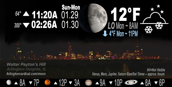
🌔 🌕 🌗 🌑 Waxing Gibbous Moon, sky cover overnight Sun. to Mon. 100%, winds NNW to NW, 9 to 11 to 10 MPH, Low 12, 8a to 10a
NWS CHGO | NWS HRLY | /NWSchicago | 🌡
ARLINGTON HEIGHTS WEATHER
▴ forecast7 (Arl. Hts.) | RADAR | WIDE RADAR
IMPORTANT NOTE ON NWS DATA
======================
NIGHT FORECASTS …
NOTE 1: Forecast and information text below may refer to a previous night on Arlingtoncardinal.com, and might not be updated until late afternoon, evening, or overnight. However, Night Sky archives on CARDINAL NEWS Magazine include text forecasts that correspond to the lunar phase graphic above.
NOTE 2: Keep in mind lunar rise and set times don’t always correspond with night weather and early morning lows because on some days during the month the moon is visible in the sky predominantly during the daytime hours.
Overnight Sunday/Monday …
Weather Hazards expected …
Limited Excessive Cold Risk tonight.
Limited Ice Accumulation Risk tonight.
Limited Snow Risk tonight.
DISCUSSION…
Some light snow could lead to a coating of accumulation late Sunday, mainly south and east of I-55, including extreme northwest Indiana. There is a chance snow could mix with or change to freezing drizzle late Sunday night south of the Kankakee River Valley.
Hello mobile users! If you encounter mobile “unfriendly” weather page, turn your phone sideways for a better view.
======================
O’HARE FORECAST …
Forecast Beginning Sunday Night, Jan. 29 , 2023 …
Sunday Night: A 30 percent chance of flurries, mainly between 11pm and 3am. Cloudy, with a low around 11. Wind chill values as low as -1. North northwest wind around 10 mph, with gusts as high as 15 mph.
Monday: Cloudy, then gradually becoming mostly sunny, with a high near 14. Wind chill values as low as -4. Northwest wind around 10 mph, with gusts as high as 20 mph.
Monday Night: Partly cloudy, with a low around -2. Wind chill values as low as -14. West northwest wind 5 to 10 mph, with gusts as high as 15 mph.
Tuesday: Mostly sunny, with a high near 15. West southwest wind 5 to 10 mph, with gusts as high as 15 mph.
Tuesday Night: Mostly clear, with a low around 7.
Wednesday: Sunny, with a high near 28.
Wednesday Night: Partly cloudy, with a low around 15.
Thursday: Sunny, with a high near 29.
Thursday Night: Partly cloudy, with a low around 7.
Friday: Mostly sunny, with a high near 20.
Friday Night: Mostly cloudy, with a low around 11.
Saturday: Mostly cloudy, with a high near 31.
O’Hare forecast archive and hourly weather observations archive are available HERE on the CARDINAL NEWS Magazine.
Arlingtoncardinal.com/moonphases
Arlingtoncardinal.com/nightsky
NIGHT SKY THIS MONTH …
Check the night sky objects for this month and past months in the playlist from the Space Telescope Science Institute YouTube channel Backyard stargazers get a monthly guide to the northern hemisphere’s skywatching events with “Tonight’s Sky” (Musical track The Far River written by Jonn Serrie, from the album And the Stars Go With You courtesy of New World Music Ltd. Musical track The Far River written by Jonn Serrie, from the album And the Stars Go With You courtesy of New World Music Ltd).
Telephoto lens, ISO 100, f/11, Shutter Speed 1/100 to 1/125 for the Moon.
Get updates from The Cardinal ALL NEWS FEEDS on Facebook. Just ‘LIKE’ the ‘Arlington Cardinal Page (become a fan of our page). The updates cover all posts and sub-category posts from The Cardinal — Arlingtoncardinal.com. You can also limit feeds to specific categories. See all of The Cardinal Facebook fan pages at Arlingtoncardinal.com/about/facebook …
Help fund The Cardinal Arlingtoncardinal.com/sponsor
Telephoto lens, ISO 1600, f/11, Shutter Speed 2.5″ for the skyline. The skyline exposure was toned down, and brightness and contrast was adjusted in Photoshop.
Area Forecast Discussion
National Weather Service Chicago/Romeoville, IL
1042 PM CST Sun Jan 29 2023
.UPDATE… Issued at 844 PM CST Sun Jan 29 2023
Going forecast appears to be in good shape this evening, and have made no adjustments except to include a slight chance of flurries a couple of hours earlier. Otherwise, forecast of flurries developing area-wide and some light snow across roughly the southeast half of the forecast area (and perhaps some patchy light freezing drizzle mixed in far south) appears to be on track.
Cold front which moved through the area yesterday is now well south of the area across the Ohio Valley while arctic high pressure spreads across the northern and central Plains. North of the cold front, the 925-700 mb baroclinic zone lingers across MO- IL-IN and will be the focus for a low-amplitude wave which transit the flow tonight into early Monday. The combined effects of this wave (tracking northeast from eastern OK/TX into AR as noted in current water vapor imagery), and increasing upper divergence in the right entrance region of a strengthening upper level jet streak over the western Great Lakes region will lead to increasing ascent and frontogenetic forcing across area overnight. RA Pforecasts suggest low-mid level f-gen will be somewhat transient, though with better focus across the southern parts of the forecast area which is also coincident with better (but not stellar) low level moisture as noted in a comparison of DVN and ILX 00Z RAOBs. Not surprisingly, guidance remains in good agreement in forecast of light measurable precip roughly south of a Peru-Chicago line across the southeast half of our forecast area. This should largely be in the form of light snow, though the slightly warmer profiles along our LOT/ILX border (greater than -10C) could support some patchy light freezing drizzle at times if not saturated to a sufficient depth for ice nucleation, though light snow is expected to be the prevailing p-type. QPF is rather light, with 0.01-0.06 supporting less than an inch of snow accumulation. Exception may be across northern Porter county, where weak lake effect band may push amounts to around an inch.
Going forecast has this all well accounted for, and have only sped up development of flurries a couple of hours to mid-evening with light snow then expected to develop toward midnight and persist overnight before moving off to the east during the pre- dawn hours.
Ratzer
&&
.SHORT TERM… Issued at 238 PM CST Sun Jan 29 2023
Through Monday night…
Key messages for the short term are:
* The likelihood of light snow / flurries between 10 PM and 5 AM, mainly along and south of I-80; non-zero chance of brief freezing drizzle south of the Kankakee River
* Colder air filtering into the area with Monday having highs in the upper single digits north to teens Chicago metro and south
* Subzero temperatures for at least far northern and north central Illinois Monday night, though some uncertainty on clouds which will influence how low temperatures dro
PStratocumulus is fairly locked in over the area this Sunday afternoon that in tandem with northerly winds has prevented temperatures from rising much at all. While a surface cold front is well south of the area near the Ohio River, elevated baroclinicity at 850-600 mb remains overhead, tightest over the southern CWA. A low amplitude wave will traverse this elevated frontal zone tonight, aided by a right entrance region of a 135+ kt upper jet. While this wave is on the weaker side in terms of amplitude and mass response, it will undulate this baroclinic zone with an area of 850-600 mb warm advection and some transient frontogenesis in smaller layers and saturated near negative EPV (low stability). Forecast saturated depths are around 7,000 ft in the far south. The lift is not all that strong, and the isothermal layer is a little warmer than the DGZ, but overall the saturation and the baroclinic zone point us to continue a higher PoP/low QPF forecast with a higher chance of light snow or flurries. High-resolution model guidance generally supports this will a spattering of light QPF. The further north in the forecast area the less likelihood of this, especially of any dusting, which is more supported south of I-80. Well south of I-80 (Gibson City IL to Rensselaer IN), the saturated temperatures in the column are warmer with only near -7C on forecast soundings. Light freezing drizzle is possible (~20-30%) in this area.
With temperatures well below freezing, any light snow for a couple hours that does materialize would easily produce a dusting, including on roads. Again this is more favored south of I-80. The timing of the light precipitation looks to be late evening into overnight, wrapping up 3-5 A.M. There would probably be a lag effect into early Monday morning on any untreated roads that do see a dusting or glaze. So will need to keep an eye on observational trends. At this time in the metro, the chance of a dusting is 10 percent north to 40 percent far south.
Otherwise for tonight, a narrow north-to-south axis of convergence on Lake Michigan will likely bring occasional flurries or light snow in far northwest Indiana beginning this evening. As for temperatures, clouds will somewhat offset the drop from the northerly winds and gradual cold advection. It`s possible lows are a smidge cool even though leaned milder than the guidance mean.
For Monday, an uptick in northwest winds will re-enforce the cold air with highs likely not to reach 20F anywhere in the CWA, and might not reach 10 over the snow-covered areas of far northern and north central Illinois. This will also be the location most favored to lose the low clouds prior to sunset Monday evening as drier air moves in ahead of a 1035 mb high pressure. There is still a signal for transient higher clouds with the upper jet remaining anchored above the region. Depending on how persistent any clouds are, lows will have a decent potential to drop into the -5F to -10F range over snow-covered, non-urban heat island locations. Farther south and east, temperatures will not be as cold, but again low confidence on sky cover means there is a fairly large spread of possible minimum temperatures.
MTF/NWS Chicago
